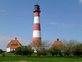
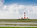
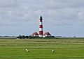
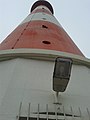
Category:Leuchtturm Westerheversand
Jump to navigation
Jump to search
| Object location | | View all coordinates using: OpenStreetMap |
|---|
lighthouse in Schleswig-Holstein, Germany     | |||||
| Upload media | |||||
| Instance of | |||||
|---|---|---|---|---|---|
| Location | Westerhever, Eiderstedt, Nordfriesland district, Schleswig-Holstein, Germany | ||||
| Located in or next to body of water | |||||
| Street address |
| ||||
| Operator | |||||
| Heritage designation | |||||
| Inception |
| ||||
| Height |
| ||||
 | |||||
English: Westerheversand Lighthouse
Subcategories
This category has only the following subcategory.
Media in category "Leuchtturm Westerheversand"
The following 181 files are in this category, out of 181 total.
-
 2016-08-07 Westerhever 01.jpg 1,536 × 2,048; 1.38 MB
-
 2016-08-07 Westerhever 04.jpg 2,592 × 3,456; 2.97 MB
-
 2016-08-07 Westerhever 05.jpg 2,592 × 3,456; 3.47 MB
-
 2016-08-07 Westerhever 06.jpg 3,456 × 2,592; 2.78 MB
-
 2016-08-07 Westerhever 07.jpg 2,592 × 3,456; 2.86 MB
-
 2016-08-07 Westerhever 08.jpg 3,456 × 2,592; 4.25 MB
-
 2016-08-07 Westerhever 14.jpg 2,592 × 3,456; 4.25 MB
-
 2016-08-07 Westerhever 15.jpg 5,184 × 3,456; 5.39 MB
-
 2016-08-07 Westerhever 17.jpg 3,456 × 5,184; 5.74 MB
-
 2016-08-07 Westerhever 19.jpg 5,184 × 3,456; 4.47 MB
-
 2016-08-07 Westerhever 22.jpg 3,456 × 5,184; 5.3 MB
-
 2016-08-07 Westerhever 23.jpg 3,456 × 5,184; 4.21 MB
-
 2016-08-07 Westerhever 24.jpg 5,184 × 3,456; 3.96 MB
-
 2016-08-07 Westerhever 25.jpg 3,456 × 5,184; 5.13 MB
-
 2016-08-07 Westerhever 26.jpg 5,184 × 3,456; 4.43 MB
-
 2016-08-07 Westerhever 27.jpg 5,184 × 3,456; 4.12 MB
-
 2016-08-07 Westerhever 28.jpg 3,456 × 5,184; 5.05 MB
-
 2016-08-07 Westerhever 29.jpg 3,456 × 5,184; 4.98 MB
-
 2016-08-07 Westerhever 30.jpg 5,184 × 3,456; 4.7 MB
-
 2016-08-07 Westerhever 32.jpg 5,184 × 3,456; 7.73 MB
-
 2016-08-07 Westhever Leuchtturm 01.jpg 3,840 × 2,160; 2.83 MB
-
 2017-04-20 Westerheversand-Leuchtturm.jpg 4,592 × 3,448; 7.82 MB
-
 54-NF-15 Westerhever.jpg 5,184 × 3,456; 6.83 MB
-
 Aerial photograph 60D 2013 09 29 9185.JPG 5,184 × 3,456; 6.42 MB
-
 Blick auf den Leuchtturm Westerheversand.JPG 4,443 × 2,498; 1.67 MB
-
 Blick von der Ordinger Strandspitze zum Leuchtturm Westerhever.jpg 5,232 × 3,488; 2.42 MB
-
 DSCF0157-5 Leuchtturm Westerheversand.jpg 5,250 × 3,500; 8.38 MB
-
 Eiderstedt-westerhever-lighthouse.jpg 467 × 701; 48 KB
-
 Hinweisschild am Westerhever Leuchtturm.JPG 3,648 × 2,736; 4.44 MB
-
 ISuedliches Waerterhaeuschen.jpg 1,565 × 1,279; 1.72 MB
-
-
 Leuchttrum Westerheversand-msu-7922-.jpg 4,740 × 3,160; 986 KB
-
 Leuchtturm am Westerhever Sand - panoramio.jpg 4,592 × 3,056; 4.01 MB
-
 Leuchtturm in Westerhever.jpg 4,000 × 6,000; 4.86 MB
-
 Leuchtturm Westerhever (47144160552).jpg 2,500 × 1,519; 1.7 MB
-
 Leuchtturm Westerhever (47144161592).jpg 2,500 × 1,767; 2.34 MB
-
 Leuchtturm Westerhever hinter Prilen.JPG 2,592 × 1,944; 1.98 MB
-
 Leuchtturm Westerhever im Morgengrauen.jpg 4,928 × 3,264; 2.95 MB
-
 Leuchtturm Westerhever.JPG 2,277 × 1,580; 585 KB
-
 Leuchtturm Westerheversand (35950855323).jpg 7,360 × 4,912; 24.86 MB
-
 Leuchtturm Westerheversand - panoramio.jpg 1,024 × 1,536; 1,002 KB
-
 Leuchtturm Westerheversand 2016.jpg 5,472 × 3,080; 3.87 MB
-
 Leuchtturm Westerheversand 2023a.jpg 3,124 × 5,581; 2.65 MB
-
 Leuchtturm Westerheversand 2023b.jpg 4,000 × 3,000; 4.66 MB
-
 Leuchtturm Westerheversand bei Nacht.jpg 3,024 × 1,998; 126 KB
-
 Leuchtturm Westerheversand blaue Stunde msu2017- msu2017-9331.jpg 5,184 × 3,456; 10.66 MB
-
 Leuchtturm Westerheversand mit ISS.jpg 3,436 × 3,436; 9.6 MB
-
 Leuchtturm Westerheversand mit Milchstraße.jpg 3,000 × 2,143; 2.89 MB
-
 Leuchtturm Westerheversand mit Wärterhäusern.jpg 2,663 × 3,551; 4.01 MB
-
 Leuchtturm Westerheversand Nordsee (50812577638).jpg 3,000 × 896; 3.01 MB
-
 Leuchtturm Westerheversand Nordsee (50812577763).jpg 3,000 × 2,000; 4.75 MB
-
 Leuchtturm Westerheversand Nordsee (50813323666).jpg 3,000 × 2,000; 5.71 MB
-
 Leuchtturm Westerheversand Nordsee (50813323756).jpg 3,000 × 2,000; 4.39 MB
-
 Leuchtturm Westerheversand Nordsee (50813323846).jpg 3,000 × 2,000; 4.7 MB
-
 Leuchtturm Westerheversand Nordsee (50813324046).jpg 3,000 × 1,999; 6.57 MB
-
 Leuchtturm Westerheversand Nordsee (50813324531).jpg 3,000 × 1,999; 6.44 MB
-
 Leuchtturm Westerheversand Nordsee (50813435842).jpg 3,000 × 2,000; 5.4 MB
-
 Leuchtturm Westerheversand, Nordfriesisches Wattenmeer.jpg 3,456 × 2,304; 2.18 MB
-
 Leuchtturm Westerheversand, Westerhever.jpg 4,000 × 3,000; 2.04 MB
-
 Leuchtturm Westerheversand-msu-2236.jpg 5,978 × 3,985; 13.01 MB
-
 Leuchtturm Westerheversand-msu-2237.jpg 6,000 × 4,000; 18.91 MB
-
 Leuchtturm Westerheversand-msu-2239.jpg 2,048 × 1,365; 2.1 MB
-
 Leuchtturm Westerheversand-msu-2240.jpg 5,826 × 3,884; 14.96 MB
-
 Leuchtturm Westerheversand-msu-5992.jpg 1,783 × 2,048; 2.69 MB
-
 Leuchtturm Westerheversand-msu-5993.jpg 1,847 × 2,048; 2.91 MB
-
 Leuchtturm Westerheversand-msu-6024.jpg 2,048 × 1,393; 2.28 MB
-
 Leuchtturm Westerheversand-msu-6057.jpg 6,000 × 4,000; 11.84 MB
-
 Leuchtturm Westerheversand-msu-6059.jpg 6,000 × 4,000; 13.81 MB
-
 Leuchtturm Westerheversand.JPG 3,164 × 2,374; 5.08 MB
-
 Leuchtturm Westerheversand.jpg 2,002 × 3,000; 2.57 MB
-
 Leuchtturm wie im Bilderbuch.jpg 4,608 × 3,072; 8.5 MB
-
 Leuchtturm-Westerheversand-msu-9621.jpg 5,962 × 2,462; 7.99 MB
-
 Leuchtturm-westerheversand-nationalpark-wattenmeer-180811-030-800px.jpg 800 × 641; 124 KB
-
 LeuchtturmWesterhever-innen.JPG 2,592 × 1,944; 1.9 MB
-
 Leutturm Westerheversand.jpg 4,032 × 3,024; 1.96 MB
-
 LIGHTHOUSE between Milkyway (Unsplash).jpg 5,560 × 3,707; 18.93 MB
-
 Lighthouse Westerheversand (107279767).jpeg 2,048 × 1,366; 1.2 MB
-
 Luftaufnahmen Nordseekueste 2012-05-by-RaBoe-079.jpg 4,107 × 2,260; 8.41 MB
-
 Luftaufnahmen Nordseekueste 2012-05-by-RaBoe-080.jpg 4,288 × 2,848; 16.73 MB
-
 Luftaufnahmen Nordseekueste 2013-09 by-RaBoe 062.jpg 2,500 × 1,659; 2.73 MB
-
 Luftaufnahmen Nordseekueste 2013-09 by-RaBoe 063.jpg 2,500 × 1,660; 2.53 MB
-
 Matthias Suessen308.jpg 3,024 × 3,024; 2.53 MB
-
 Matthias Suessen318.jpg 1,786 × 2,599; 925 KB
-
 Matthias Suessen319.jpg 3,818 × 2,863; 2.05 MB
-
 Matthias Suessen324.jpg 3,024 × 3,024; 2.02 MB
-
 Matthias Suessen334.jpg 3,941 × 2,957; 2.52 MB
-
 Matthias Suessen342.jpg 3,902 × 2,926; 2.41 MB
-
 Nationalpark Leuchtturm Westerheversand-msu-6017.jpg 2,011 × 2,048; 3.01 MB
-
 Nationalpark Leuchtturm Westerheversand-msu-6018.jpg 1,839 × 2,048; 2.91 MB
-
 Nationalpark Leuchtturm Westerheversand-msu-6022.jpg 1,951 × 2,048; 2.85 MB
-
 Nationalpark Leuchtturm Westerheversand-msu-6023.jpg 1,679 × 2,048; 2.16 MB
-
 Nationalpark Leuchtturm Westerheversand-msu-6027.jpg 2,048 × 1,402; 2.01 MB
-
 Nationalpark Leuchtturm Westerheversand-msu-6034.jpg 2,048 × 1,365; 2.35 MB
-
 Nationalpark Schleswig-Holsteinisches Wattenmeer - Leuchtturm Westerheve.jpg 4,562 × 2,566; 2.88 MB
-
 Nationalpark Schleswig-Holsteinisches Wattenmeer, –Westerhever–.jpg 5,405 × 3,326; 8.81 MB
-
 Nationalpark Wattenmeer in Westerhever mit Leuchtturm.jpg 3,264 × 2,448; 158 KB
-
 Noerdliches Waerterhaeuschen.jpg 5,184 × 3,456; 5.33 MB
-
 Nordsee - Leuchtturm Westerheversand auf der Halbinsel Eiderstedt.jpg 652 × 1,000; 86 KB
-
 Nordsee 123.jpg 2,240 × 1,680; 1.27 MB
-
 Nordsee 9820.jpg 5,838 × 4,379; 18.57 MB
-
 Priel mit Leuchtturm.jpg 4,592 × 2,576; 4.25 MB
-
 Ringelgänse vor dem Leuchtturm.jpg 2,000 × 1,125; 390 KB
-
 Salzwiesen und Leuchtturm Westerheversand.jpg 3,898 × 2,867; 5.14 MB
-
 Salzwiesen vor dem Leuchtturm Westerheversand.jpg 5,250 × 3,500; 8.95 MB
-
 Schaf vor Westerheversand Leuchtturm.jpg 3,456 × 2,304; 2.42 MB
-
 Schleswig Holstein 25881 Leuchtturm Westerheversand.jpg 6,960 × 4,640; 8.44 MB
-

-
 Schäfchen vor dem Leuchtturm Westerheversand.jpg 3,456 × 2,304; 3.69 MB
-
 Stars and Fire.jpg 500 × 333; 143 KB
-

-
 Stockenstieg-msu-6047.jpg 5,707 × 3,805; 14.57 MB
-
 Tönning Wikivoyage Banner.jpg 11,413 × 1,637; 2.39 MB
-
 Westerhever - Leuchtturm - geo.hlipp.de - 10136.jpg 425 × 640; 100 KB
-
 Westerhever - panoramio (1).jpg 3,872 × 2,592; 1.38 MB
-
 Westerhever - panoramio (2).jpg 3,202 × 1,800; 3.2 MB
-
 Westerhever - panoramio - cisko66.jpg 2,592 × 3,872; 5.4 MB
-
 Westerhever - panoramio.jpg 11,413 × 2,592; 3.78 MB
-
 Westerhever - Salzwiesen - geo.hlipp.de - 10135.jpg 640 × 425; 86 KB
-
 Westerhever 01.JPG 2,048 × 1,536; 200 KB
-
 Westerhever 02.JPG 2,048 × 1,536; 120 KB
-
 Westerhever 2004 a.jpg 640 × 480; 117 KB
-
 Westerhever im Juli.jpg 2,343 × 3,500; 7.18 MB
-
 Westerhever Leuchtturm (1).jpg 1,815 × 1,284; 465 KB
-
 Westerhever Leuchtturm (2).jpg 2,560 × 1,920; 1.11 MB
-
 Westerhever Leuchtturm (49784105466).jpg 3,000 × 896; 3 MB
-
 Westerhever Leuchtturm - panoramio (1).jpg 4,592 × 3,056; 3.43 MB
-
 Westerhever Leuchtturm - panoramio (2).jpg 4,592 × 3,056; 4.41 MB
-
 Westerhever Leuchtturm - panoramio.jpg 3,056 × 4,592; 4.61 MB
-
 Westerhever leuchtturm 02.jpg 1,387 × 1,849; 911 KB
-
 Westerhever Leuchtturm 03.jpg 2,000 × 1,333; 410 KB
-
 Westerhever Leuchtturm 04.jpg 2,000 × 1,333; 339 KB
-
 Westerhever Leuchtturm 1.jpg 3,624 × 2,704; 1.14 MB
-
 Westerhever Leuchtturm 27BDDAA9-710D-4218-8E3D-0BF8384BE53D.jpg 4,032 × 3,024; 940 KB
-
 Westerhever Leuchtturm Front.jpg 4,592 × 2,576; 4.38 MB
-
 Westerhever Leuchtturm Fußweg.jpg 800 × 600; 76 KB
-
 Westerhever leuchtturm hinter salzwiese.JPG 3,072 × 1,728; 1.69 MB
-
 Westerhever Leuchtturm in Schleswig-Holstein.jpg 1,800 × 1,200; 268 KB
-
 Westerhever leuchtturm und salzwiesen 2.jpg 4,272 × 2,848; 3.25 MB
-
 Westerhever Leuchtturm Westerheversand.jpg 1,500 × 1,000; 1.44 MB
-
 Westerhever Leuchtturm.jpg 2,154 × 1,431; 241 KB
-
 Westerhever Nordostblick 02.jpg 6,444 × 4,445; 6.15 MB
-
 Westerhever Nordostblick.jpg 10,000 × 5,427; 13.13 MB
-
 Westerhever salzwiesen 6.jpg 2,014 × 1,509; 1.33 MB
-
 Westerhever Salzwiesen-2.jpg 1,600 × 900; 450 KB
-
 Westerhever Salzwiesen.jpg 1,600 × 900; 568 KB
-
 Westerhever watt und leuchtturm.jpg 2,006 × 1,504; 1.3 MB
-
 Westerhever Westblick RB.jpg 4,000 × 2,344; 1.74 MB
-
 Westerhever- Salzwiesen - Leuchtturm - geo.hlipp.de - 25566.jpg 640 × 480; 45 KB
-
 Westerhever-msu-9494.jpg 5,393 × 3,736; 13.88 MB
-
 Westerhever.jpg 1,942 × 1,457; 1.04 MB
-
 WesterHever1.jpg 640 × 480; 75 KB
-
 Westerheversand 20200902.jpg 5,504 × 3,096; 8.78 MB
-
 Westerheversand Leuchtturm 1.jpg 3,648 × 2,736; 1.86 MB
-
 Westerheversand Leuchtturm mit Salzwiesen.jpg 1,800 × 1,200; 283 KB
-
 Westerheversand Leuchtturm-01.jpg 4,237 × 3,178; 3.4 MB
-
 Westerheversand Leuchtturm-02.jpg 4,237 × 3,178; 3.52 MB
-
 Westerheversand Leuchtturm.JPG 3,648 × 2,736; 4.61 MB
-
 Westerheversand Leuchtturm.jpg 3,408 × 2,400; 3.22 MB
-
 Westerheversand Lighthouse 017 3241.jpg 5,837 × 3,891; 17.19 MB
-
 Westerheversand Lighthouse 017 3253.jpg 3,891 × 4,558; 14.3 MB
-
 Westerheversand Lighthouse 017 3261.jpg 8,044 × 5,363; 27.28 MB
-
 Westerheversand lighthouse 26.08.2011 11-38-56.JPG 4,672 × 3,104; 8.16 MB
-
 Westerheversand Lighthouse Winter.jpg 1,020 × 1,536; 1,013 KB
-
 Westerheversand Lighthouse.jpg 2,048 × 1,360; 1.5 MB
-
 Westerheversand msu 2018-9337.jpg 5,090 × 3,393; 11.76 MB
-
 Westerheversand Nordfriesland.jpg 1,920 × 2,560; 1.47 MB
-
 Westerheversand-2019-msu-5993.jpg 2,273 × 2,521; 4.16 MB
-
 Westerheversand-2019-msu-6024.jpg 4,859 × 3,305; 11.01 MB
-
 Westerheversand-2019-msu-6029.jpg 6,000 × 4,000; 16.39 MB
-
 Westerheversand-2019-msu-6038.jpg 5,195 × 2,241; 7.88 MB
-
 Westerheversand-2019-msu-6047.jpg 5,707 × 3,805; 15.55 MB
-
 Westerheversand-2022 05 msu-2754-.jpg 4,563 × 3,034; 1.92 MB
-
 Westerheversand-2022 05 msu-9526-.jpg 5,613 × 3,064; 1.96 MB
-
 Westerheversand-2022 05 msu-9568-.jpg 4,672 × 3,115; 1.89 MB
-
 Westerheversand-IMG 1680a.jpg 6,960 × 4,640; 6.7 MB
-
 Westerheversand-msu-9571.jpg 2,048 × 1,365; 1.76 MB
-
 Westerheversand-msu-9623.jpg 6,000 × 3,479; 12.51 MB
-
 Westerheversand-msu-9628.jpg 5,948 × 2,403; 8.24 MB
-
 Westerheversand.jpg 1,024 × 768; 50 KB
-
 Wetserheversand-msu-5998.jpg 5,270 × 3,067; 19.68 MB
-
 Wiesenpieper beim Westerhever Leuchtturm.jpg 3,264 × 4,896; 5.41 MB


.jpg)
.jpg)


.jpg)


.jpg)
.jpg)
.jpg)
.jpg)
.jpg)
.jpg)
.jpg)


.jpg)
.jpeg)


.jpg)
.jpg)


.jpg)
.jpg)
.jpg)
.jpg)


.jpg)
.jpg)
Categories:
- Lighthouses in Schleswig-Holstein
- Lighthouses in Germany by name
- 1900s lighthouses in Germany
- Built in Schleswig-Holstein in 1908
- Lighthouses built in 1908
- Castings by Isselburger Hütte
- Cultural heritage monuments in Westerhever
- Wasserstraßen- und Schifffahrtsamt Tönning
- Nationalpark Schleswig-Holsteinisches Wattenmeer
- Red and white lighthouses in Germany
- Lighthouses by range, 20 to 24 nm
- Landfall lights
- Cast-iron lighthouses
- Cast-iron lighthouses in Germany