Category:Leodagger Bildstock 2 GstNr 1009
Jump to navigation
Jump to search
| Object location | | View all coordinates using: OpenStreetMap |
|---|
 | |||||
| Upload media | |||||
| Instance of | |||||
|---|---|---|---|---|---|
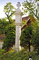
| Location | Pulkau, Hollabrunn District, Lower Austria, Austria | ||||
| Heritage designation | |||||
 | |||||
Deutsch: Bildstock in Leodagger, Gemeinde Pulkau
Media in category "Leodagger Bildstock 2 GstNr 1009"
The following 3 files are in this category, out of 3 total.
-
 Leodagger Bildstock 2 GstNr 1009 Detail1.jpg 1,700 × 2,684; 2.62 MB
-
 Leodagger Bildstock 2 GstNr 1009 Detail2.jpg 1,921 × 2,966; 3.5 MB
-
 Leodagger Bildstock 2 GstNr 1009.jpg 1,942 × 2,952; 4.64 MB

