Category:Leemcule
Jump to navigation
Jump to search
| Object location | | View all coordinates using: OpenStreetMap |
|---|
 | |||||
| Upload media | |||||
| Instance of | |||||
|---|---|---|---|---|---|
| Location | Dalfsen, Overijssel, Netherlands | ||||
| Has part(s) | |||||
| Heritage designation |
| ||||
 | |||||
|
This is a category about rijksmonumentcomplex number 512360
|
Buitenplaatas:
|
This is a category about rijksmonument number 512359
|
Historische tuin- en parkaanleg:
|
This is a category about rijksmonument number 512361
|
Bouwhuizen:
|
This is a category about rijksmonument number 512362
|
Inrijhek:
|
This is a category about rijksmonument number 512363
|
Tuinmuur:
|
This is a category about rijksmonument number 512364
|
Brug:
|
This is a category about rijksmonument number 512366
|
| Address |
|
Media in category "Leemcule"
The following 8 files are in this category, out of 8 total.
-
 "De Leemcule", gevel - Dalfsen - 20047609 - RCE.jpg 1,200 × 960; 293 KB
-
 "Leemcule", gevel - Dalfsen - 20047612 - RCE.jpg 1,200 × 954; 232 KB
-

-
 "Leemcule", voorgevel (1824) - Dalfsen - 20047610 - RCE.jpg 1,200 × 807; 252 KB
-

-
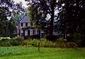
 512359 Dalfsen Huize Leemcule 2010.JPG 3,456 × 2,304; 3.77 MB
-

-
 Leemcule bouwhuis.jpg 2,141 × 1,475; 484 KB


_-_Dalfsen_-_20047610_-_RCE.jpg)


