Category:Lage der A 5-6 (Groningen)
Jump to navigation
Jump to search
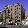
Nederlands: De (voormalige) pakhuizen Lage der A 5 (Friesland) en 6 (voorheen 6 en 7, De Vooruitgang), samen gem. mon. 102488
| Object location | | View all coordinates using: OpenStreetMap |
|---|
|
This is a category about a municipal monument in Groningen with number 102488 |
Media in category "Lage der A 5-6 (Groningen)"
The following 5 files are in this category, out of 5 total.
-
 Groningen - Lage der A 5-7 (2).jpg 3,721 × 3,721; 8.62 MB
-
 Groningen - Lage der A 5-7.jpg 3,073 × 4,610; 9.78 MB
-
 Overzicht - Groningen - 20094004 - RCE.jpg 1,200 × 951; 273 KB
-
 Overzicht - Groningen - 20094005 - RCE.jpg 1,200 × 955; 268 KB
-
 Voorgevel - Groningen - 20094003 - RCE.jpg 1,200 × 1,188; 305 KB
.jpg)


