Category:Labelled administrative maps of France
Jump to navigation
Jump to search
Media in category "Labelled administrative maps of France"
The following 15 files are in this category, out of 15 total.
-
 1789 + 2022 Auvergne-Rhône-Alpes, noms.png 1,416 × 1,209; 206 KB
-
 1789 + 2022 Bourgogne-Franche-Comté, noms.png 1,451 × 1,290; 222 KB
-
 1789 + 2022 Bretagne, noms.png 1,135 × 873; 101 KB
-
 1789 + 2022 France, noms des régions.png 4,264 × 4,098; 1.34 MB
-
 1789 + 2022 Grand Est, noms.png 1,583 × 1,125; 210 KB
-
 1789 + 2022 Hauts-de-France + Île, noms.png 866 × 1,378; 136 KB
-
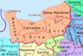 1789 + 2022 Normandie, noms.png 1,228 × 836; 117 KB
-
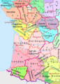 1789 + 2022 Nouvelle Aquitaine, noms.png 1,361 × 1,895; 277 KB
-
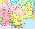 1789 + 2022 Occitanie, noms.png 1,483 × 1,260; 204 KB
-
 1789 + 2022 Pays de la Loire, noms.png 1,130 × 1,134; 150 KB
-
 1789 + 2022 Provence, noms.png 984 × 914; 100 KB
-
 1789 + 2022 Île-de-France216.png 2,025 × 1,554; 595 KB
-
 1789 et 2022, Centre-Val de Loire et Île-de-France, noms.png 1,200 × 1,368; 188 KB
-
 2022 France - régions et départements, noms hu.png 1,842 × 1,696; 1.11 MB
-
 2022 France - régions et départements, noms.png 1,842 × 1,696; 619 KB


