Category:Kyffhäuserland
Jump to navigation
Jump to search
municipality in Germany    | |||||
| Upload media | |||||
| Instance of |
| ||||
|---|---|---|---|---|---|
| Location | Kyffhäuserkreis, Thuringia, Germany | ||||
| Population |
| ||||
| Area |
| ||||
| Elevation above sea level |
| ||||
| Replaces |
| ||||
| official website | |||||
 | |||||
Kyffhäuserkreis  Abtsbessingen · An der Schmücke · Artern · Bad Frankenhausen/Kyffhäuser · Bellstedt · Borxleben · Clingen · Ebeleben · Etzleben · Freienbessingen · Gehofen · Greußen · Helbedündorf · Holzsußra · Kalbsrieth · Kyffhäuserland · Mönchpfiffel-Nikolausrieth · Niederbösa · Oberbösa · Oberheldrungen · Reinsdorf · Rockstedt · Roßleben-Wiehe · Sondershausen · Topfstedt · Trebra · Wasserthaleben · Westgreußen ·
Subcategories
This category has the following 9 subcategories, out of 9 total.
Media in category "Kyffhäuserland"
The following 11 files are in this category, out of 11 total.
-
 Blick vom Südende des Kyffhäusser Richtung Westen Sondershausen und Hainleite.jpg 3,505 × 2,336; 8.51 MB
-
 Blick zum Südende des Kyffhäusser Gebirges.jpg 3,613 × 2,409; 8.96 MB
-
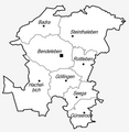 Gemeindegliederung Kyffhland.png 2,864 × 2,935; 326 KB
-
 Hainleite - Marienborn - Wanderkreuz - panoramio.jpg 2,736 × 3,648; 3.35 MB
-
 Karte Kyffhäusergebirge 20210914 HOF06002 RAW-Export 20220415002132.jpg 9,504 × 6,336; 36.73 MB
-
 Kyffhäusergebirge mit umliegenden Ortschaften.jpg 1,727 × 903; 306 KB
-
 Wappen Kyffhäuserland.png 257 × 283; 92 KB
-
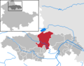 Kyffhäuserland in KYF.png 299 × 235; 5 KB
-
 Pause am See - panoramio.jpg 2,592 × 1,552; 752 KB
-
 Steinthaleben am Kyffhäuser.jpg 1,600 × 1,200; 505 KB
-
 Thaleber (Badraer) Bach.jpg 5,376 × 3,024; 9.68 MB


_Bach.jpg)