Category:Kruithuis (Delft)
Jump to navigation
Jump to search
| Object location | | View all coordinates using: OpenStreetMap |
|---|
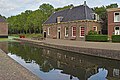
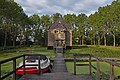
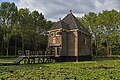
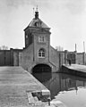
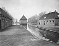
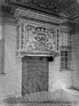
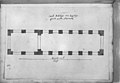
gunpowder storage building in Delft on the Schie, built outside the city after the Delft explosion of 1654  | |||||
| Upload media | |||||
| Instance of | |||||
|---|---|---|---|---|---|
| Location | Delft, South Holland, Netherlands | ||||
| Located in or next to body of water | |||||
| Street address |
| ||||
| Located on street | |||||
| Heritage designation |
| ||||
| Inception |
| ||||
 | |||||
|
This is a category about rijksmonument number 12167
|
| Address |
|
Media in category "Kruithuis (Delft)"
The following 81 files are in this category, out of 81 total.
-
 Aan de Schie - Delft - 20049071 - RCE.jpg 886 × 1,200; 197 KB
-
 Aan de Schie - Delft - 20049072 - RCE.jpg 890 × 1,200; 130 KB
-
 Delft PowderHouse 017 4923.jpg 5,670 × 6,835; 26.73 MB
-
 Delft PowderHouse 017 4941.jpg 5,938 × 3,959; 25.32 MB
-
 Delft PowderHouse 017 4953.jpg 4,000 × 4,763; 14.97 MB
-
 Delft PowderHouse 017 4983.jpg 6,797 × 4,531; 24.66 MB
-
 Delft PowderHouse 017 4998.jpg 6,000 × 4,000; 25.04 MB
-
 Delft PowderHouse 017 5001.jpg 5,937 × 3,958; 23.71 MB
-
 Delft PowderHouse 017 5134.jpg 5,988 × 3,989; 25.89 MB
-
 Delft PowderHouse 017 5168.jpg 5,868 × 3,916; 27 MB
-
 Delft PowderHouse 017 5175.jpg 7,797 × 5,198; 38.17 MB
-
 Delft PowderHouse 017 5201.jpg 2,842 × 2,796; 6.82 MB
-
 Delft PowderHouse 017 5204.jpg 3,676 × 5,921; 20.25 MB
-
 Delft PowderHouse 017 5206.jpg 5,668 × 3,779; 23.78 MB
-
 Delft PowderHouse 017 5215.jpg 5,886 × 3,863; 20.32 MB
-
 Delft PowderHouse 017 5224.jpg 6,000 × 4,000; 20.93 MB
-
 Delft PowderHouse 017 5230.jpg 5,763 × 3,842; 17.97 MB
-
 DelftscheZwervers.jpg 600 × 450; 53 KB
-
 Exterieur - Delft - 20049068 - RCE.jpg 940 × 1,200; 265 KB
-
 Exterieur - Delft - 20049069 - RCE.jpg 944 × 1,200; 219 KB
-
 Exterieur - Delft - 20049070 - RCE.jpg 1,200 × 945; 284 KB
-
 Kruithuis Delft 2019 2.jpg 4,928 × 3,264; 6.51 MB
-
 Kruithuis Delft 2019 3.jpg 3,264 × 4,928; 6.76 MB
-
 Kruithuis Delft 2019 4.jpg 4,928 × 3,264; 7.37 MB
-
 Kruithuis Delft 2019 5.jpg 3,264 × 4,928; 7.13 MB
-
 Kruithuis Delft 2019.jpg 4,928 × 3,264; 7.73 MB
-
 Kruithuis Delft 2020.jpg 4,000 × 3,000; 5.72 MB
-
 Kruithuis schouw.jpg 2,448 × 3,264; 2.04 MB
-
 Kruithuis.jpg 2,048 × 1,536; 483 KB
-
 Kruithuiswinter.jpg 338 × 233; 7 KB
-
 Kruittoren Delft.JPG 2,448 × 3,264; 2.68 MB
-
 Kruittoren met op de achtergrond het poortgebouw - Delft - 20049108 - RCE.jpg 1,200 × 894; 258 KB
-
 Kruittorens met op de achtergrond het poortgebouw - Delft - 20049109 - RCE.jpg 1,200 × 894; 269 KB
-
 Munitiedepot - Delft - 20049065 - RCE.jpg 960 × 1,200; 224 KB
-
 Munitiedepot - Delft - 20049066 - RCE.jpg 1,200 × 936; 270 KB
-
 Munitiedepot - Delft - 20049067 - RCE.jpg 1,200 × 957; 279 KB
-

-

-
 Overzicht kruittoren vanaf de waterkant - Delft - 20389913 - RCE.jpg 1,200 × 956; 328 KB
-

-
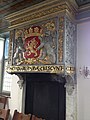
 Poortgebouw met het wapen van de Generaliteit - Delft - 20049104 - RCE.jpg 1,200 × 894; 276 KB
-
 Poortgebouw met het wapen van de Generaliteit - Delft - 20049105 - RCE.jpg 894 × 1,200; 274 KB
-
 Poortgebouw, het wapen van de Generaliteit - Delft - 20049106 - RCE.jpg 894 × 1,200; 224 KB
-
-
 Schiekade, torenkamer plafond - Delft - 20049112 - RCE.jpg 802 × 1,200; 202 KB
-
 Slotplaat - Delft - 20049116 - RCE.jpg 798 × 1,200; 177 KB
-
 Steigers vernieuwd 1970 - Delft - 20049115 - RCE.jpg 1,200 × 784; 211 KB
-
 Steigers vernieuwd 1970 - Delft - 20353860 - RCE.jpg 788 × 1,200; 267 KB
-

-

-

-

-

-

-

-

-

-

-

-

-

-

-

-

-

-

-
-

-

-

-

-

-

-

-

-

-

-

-
 Torenkamer schoorsteen - Delft - 20049111 - RCE.jpg 811 × 1,200; 160 KB
-
 Vooraanzicht - Delft - 20049114 - RCE.jpg 944 × 1,200; 194 KB
-
 Zijaanzicht van het poortgebouw - Delft - 20049107 - RCE.jpg 1,200 × 894; 322 KB


