Category:Kramer Covered Bridge
Jump to navigation
Jump to search
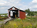
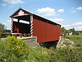
English: Kramer Covered Bridge No. 113 built in 1881 over Mud Run in Greenwood Township in Columbia County, Pennsylvania in the United States.
|
This is a category about a place or building that is listed on the National Register of Historic Places in the United States of America. Its reference number is 79003194. |
| Object location | | View all coordinates using: OpenStreetMap |
|---|
covered bridge in Columbia County, Pennsylvania  | |||||
| Upload media | |||||
| Instance of | |||||
|---|---|---|---|---|---|
| Location | Columbia County, Pennsylvania | ||||
| Crosses | |||||
| Heritage designation |
| ||||
 | |||||
Media in category "Kramer Covered Bridge"
The following 16 files are in this category, out of 16 total.
-
 Ceiling of the Kramer Covered Bridge.JPG 2,256 × 1,504; 4.72 MB
-
 KRAMER C.B., COLUMBIA CO. PA.jpg 5,277 × 3,474; 1.5 MB
-
 Kramer Covered Bridge 1.JPG 3,648 × 2,736; 2.8 MB
-
 Kramer Covered Bridge 10.JPG 3,648 × 2,736; 2.64 MB
-
 Kramer Covered Bridge 11.jpg 4,478 × 1,278; 2.06 MB
-
 Kramer Covered Bridge 2.JPG 3,648 × 2,736; 2.24 MB
-
 Kramer Covered Bridge 3.jpg 6,898 × 3,633; 2.59 MB
-
 Kramer Covered Bridge 4.JPG 2,736 × 3,648; 2.33 MB
-
 Kramer Covered Bridge 5.JPG 3,648 × 2,736; 2.63 MB
-
 Kramer Covered Bridge 6.JPG 3,648 × 2,736; 2.52 MB
-
 Kramer Covered Bridge 7.JPG 3,648 × 2,736; 2.89 MB
-
 Kramer Covered Bridge 8.JPG 3,648 × 2,736; 3.36 MB
-
 Kramer Covered Bridge 9.JPG 3,648 × 2,736; 3.07 MB
-
 Kramer Covered Bridge closeup.JPG 2,256 × 1,504; 1.96 MB
-
 KRAMER COVERED BRIDGE, COLUMBIA CO. PA.jpg 5,244 × 3,482; 1.62 MB
-
 Kramer Covered Bridge.JPG 2,256 × 1,504; 3.16 MB


Categories:
- National Register of Historic Places in Columbia County, Pennsylvania
- Covered bridges in Pennsylvania
- Greenwood Township, Columbia County, Pennsylvania
- Bridges in Columbia County, Pennsylvania
- Bridges on the National Register of Historic Places in Pennsylvania
- Mud Run (Green Creek)
- Bridges numbered 113
- Covered bridges on the National Register of Historic Places in Pennsylvania