Category:Kraftwerk Laufenburg
Jump to navigation
Jump to search
| Object location | | View all coordinates using: OpenStreetMap |
|---|
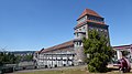
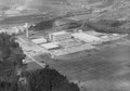
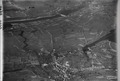
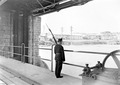
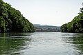
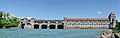
hydroelectric power station in Laufenburg in the canton of Aargau, Switzerland  | |||||
| Upload media | |||||
| Instance of | |||||
|---|---|---|---|---|---|
| Part of | |||||
| Location | Laufenburg, Laufenburg District, Aargau, Switzerland | ||||
| Located in or next to body of water | |||||
| Street address |
| ||||
| Operator |
| ||||
| Heritage designation | |||||
| Inception |
| ||||
| Nominal power capacity |
| ||||
 | |||||
Media in category "Kraftwerk Laufenburg"
The following 38 files are in this category, out of 38 total.
-
 2022-08-09 Kraftwerk Laufenburg 01.jpg 4,000 × 2,248; 3.8 MB
-
 2022-08-09 Kraftwerk Laufenburg 02.jpg 4,000 × 2,248; 4.11 MB
-
 2022-08-09 Kraftwerk Laufenburg 03.jpg 4,000 × 2,248; 3.9 MB
-
 2022-08-09 Kraftwerk Laufenburg 04.jpg 2,248 × 4,000; 4.02 MB
-

-
 ETH-BIB-Kaisten, Ciba-Geigy-LBS H1-028558.tif 6,629 × 4,660; 88.42 MB
-
 ETH-BIB-Kaisten, Laufenburg-Inlandflüge-LBS MH01-002643.tif 6,321 × 4,414; 79.92 MB
-
 ETH-BIB-Kaisten, Laufenburg-Inlandflüge-LBS MH01-002644.tif 6,450 × 4,355; 80.5 MB
-
 ETH-BIB-Laufenburg, E.W.Laufenburg v. S. O. aus 250 m-Inlandflüge-LBS MH01-005847.tif 5,973 × 4,645; 79.57 MB
-
 ETH-BIB-Laufenburg, E.W.Laufenburg-LBS H1-014964.tif 6,532 × 4,483; 83.91 MB
-
 ETH-BIB-Laufenburg, Elektrizitätswerk-Inlandflüge-LBS MH03-0625.tif 6,389 × 4,407; 80.67 MB
-
 ETH-BIB-Laufenburg, Elektrizitätswerk-Inlandflüge-LBS MH03-0626.tif 6,482 × 4,359; 80.92 MB
-
 ETH-BIB-Laufenburg, Elektrizitätswerk-Inlandflüge-LBS MH03-1261.tif 6,465 × 4,353; 80.62 MB
-
 ETH-BIB-Laufenburg, Holzbetrieb und Elektrizitätswerk-Inlandflüge-LBS MH03-0624.tif 6,339 × 4,413; 80.15 MB
-
 ETH-BIB-Laufenburg, Holzbetrieb und Elektrizitätswerk-Inlandflüge-LBS MH03-1611.tif 6,289 × 4,337; 78.17 MB
-

-
 ETH-BIB-Laufenburg, Kraftwerk Laufenburg-LBS H1-009278.tif 6,372 × 4,417; 80.66 MB
-
 ETH-BIB-Laufenburg-LBS H1-018451.tif 6,858 × 4,824; 94.8 MB
-
 Grenzwachtposten im Kraftwerk Laufenburg - CH-BAR - 3240546.tif 3,000 × 2,134; 888 KB
-
 Grenzwachtposten im Kraftwerk Laufenburg - CH-BAR - 3240547.tif 3,000 × 2,134; 866 KB
-
 Hochrheinfahrt-kraftwerk-laufenburg-ausbootstelle.JPG 3,200 × 2,133; 1.67 MB
-
 Hochrheinfahrt-kraftwerk-laufenburg-bootslift-b.JPG 3,200 × 2,133; 2.17 MB
-
 Hochrheinfahrt-kraftwerk-laufenburg-bootslift.JPG 3,200 × 2,133; 2.34 MB
-
 Hochrheinfahrt-kraftwerk-laufenburg-unterwasser.JPG 3,200 × 2,133; 1.67 MB
-
 Hochrheinfahrt-kraftwerk-laufenburg.JPG 3,200 × 2,133; 1.47 MB
-
 Kraftwerk Laufenburg P1100918.jpg 2,048 × 1,536; 1.34 MB
-
 Kraftwerk Laufenburg.jpg 4,000 × 2,665; 3.36 MB
-
 Kraftwerk-Laufenburg-054233.JPG 4,032 × 3,024; 2.84 MB
-
 Kraftwerk-Laufenburg-054239.JPG 3,959 × 2,870; 2.16 MB
-
 Kraftwerk-Laufenburg-054248.JPG 3,733 × 2,608; 1.81 MB
-
 Laufenburg Wasserkraftwerk.JPG 2,048 × 1,536; 652 KB
-
 Schleuse Laufenburg P1100912.jpg 1,536 × 2,048; 1.27 MB
-
 Wachtmannschaft auf dem Areal des Kraftwerks Laufenburg - CH-BAR - 3240545.tif 3,000 × 2,134; 863 KB
-
 Wachtposten beim Kraftwerk Laufenburg - CH-BAR - 3240542.tif 3,000 × 2,134; 672 KB
-
 Wachtposten beim Kraftwerk Laufenburg - CH-BAR - 3240544.tif 3,000 × 2,134; 738 KB
-
 Wasserkraftwerk Laufenburg1.jpg 8,601 × 2,698; 15.13 MB
-
 Wasserkraftwerk Laufenburg2.jpg 8,905 × 3,075; 15.63 MB
-
 Wasserkraftwerk Laufenburg4.jpg 2,616 × 1,485; 1.99 MB


