Category:Knappengasthaus, Bundschuh
Jump to navigation
Jump to search
| Object location | | View all coordinates using: OpenStreetMap |
|---|
 | |||||
| Upload media | |||||
| Instance of | |||||
|---|---|---|---|---|---|
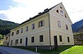
| Location | Thomatal, Tamsweg District, Salzburg, Austria | ||||
| Street address |
| ||||
| Heritage designation | |||||
 | |||||
Deutsch: Wohnkomplex in Bundschuh, Gemeinde Thomatal. Ehemaliges Knappengasthaus.
Media in category "Knappengasthaus, Bundschuh"
The following 4 files are in this category, out of 4 total.
-
 Bundschuh 15 Knappengasthaus 001.JPG 4,928 × 3,264; 8.8 MB
-
 Bundschuh 15 Knappengasthaus 002.JPG 4,928 × 3,264; 9.93 MB
-
 Thomatal Bundschuh 15 Knappengasthaus 2014-001.jpg 1,920 × 1,277; 930 KB
-
 Thomatal Bundschuh 15 Knappengasthaus 2014-002.jpg 1,920 × 1,277; 926 KB


