Category:Klaauwshofje
Jump to navigation
Jump to search
| Object location | | View all coordinates using: OpenStreetMap |
|---|
 | |||||
| Upload media | |||||
| Instance of | |||||
|---|---|---|---|---|---|
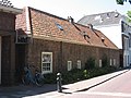
| Location | Delft, South Holland, Netherlands | ||||
| Street address |
| ||||
| Located on street |
| ||||
| Heritage designation |
| ||||
 | |||||
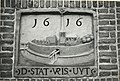
Nederlands: De gemeente Delft gebruikt een andere schrijfwijze, namelijk: Klaeuwshofje.zie [1]
English: The city of Delft uses a different spelling, namely: Klaeuwshofje.
|
This is a category about rijksmonument number 11969
|
| Address |
|
Media in category "Klaauwshofje"
The following 9 files are in this category, out of 9 total.
-
 Delft - Oranjeplantage 58-79.jpg 2,592 × 1,944; 1.49 MB
-
 Klaauwshofje Delft 1605.jpg 3,264 × 2,448; 4.04 MB
-
 Klaauwshofje Delft.jpg 2,448 × 3,264; 1.95 MB
-
 Klaeuwshofje, poortje - Delft - 20050519 - RCE.jpg 891 × 1,200; 184 KB
-
 Klaeuwshofje, poortje - Delft - 20050520 - RCE.jpg 883 × 1,200; 225 KB
-
 Klaushof, aanzicht - Delft - 20052308 - RCE.jpg 1,200 × 945; 249 KB
-
 Klaushof, aanzicht - Delft - 20052309 - RCE.jpg 1,200 × 962; 352 KB
-

-
 Vris uyt JH.jpg 4,178 × 2,824; 4.21 MB


