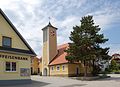
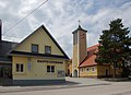
Category:Kirche Maria Hilf (Lacken)
Jump to navigation
Jump to search
| Object location | | View all coordinates using: OpenStreetMap |
|---|
| This category shows the protected monument with the number 22061 in Austria. (Commons, de, Wikidata) |
church building in Feldkirchen an der Donau, Austria _01.jpg) | |||||
| Upload media | |||||
| Instance of | |||||
|---|---|---|---|---|---|
| Named after | |||||
| Location | Feldkirchen an der Donau, Urfahr-Umgebung District, Upper Austria, Austria | ||||
| Heritage designation |
| ||||
 | |||||
Media in category "Kirche Maria Hilf (Lacken)"
The following 3 files are in this category, out of 3 total.
-
 Kirche Maria Hilf (Lacken) 01.jpg 2,708 × 1,976; 3.64 MB
-
 Kirche Maria Hilf (Lacken) 02.jpg 2,700 × 1,956; 3.42 MB
-
 Kirche Maria Hilf (Lacken) 03.jpg 2,742 × 1,980; 3.4 MB
_02.jpg)
_03.jpg)