Category:Kilby
Jump to navigation
Jump to search
English: Kilby is a village and civil parish in the Blaby district of Leicestershire, England. It is the easternmost village in the district, and is south of Leicester. It has a population of about 300. Kilby has only one pub called the Dog & Gun, An Anglican Primary School and a Parish Church. There is also a park for the residents of Kilby. The park has a small football field, swings, a roundabout, climbing obstacles and a picnic table. There is a public bus service that runs at hourly intervals that connects with Fleckney or directly to St-Margaret's Bus Station, Leicester. There is also a small elderly community.
village and civil parish in Leicestershire, United Kingdom | |||||
| Upload media | |||||
| Instance of | |||||
|---|---|---|---|---|---|
| Location | Blaby, Leicestershire, East Midlands, England | ||||
| Different from | |||||
| Said to be the same as | Kilby (Wikimedia duplicated page, civil parish) | ||||
 | |||||
Subcategories
This category has the following 2 subcategories, out of 2 total.
F
K
Media in category "Kilby"
The following 156 files are in this category, out of 156 total.
-
 A bend in Foston Road - geograph.org.uk - 4343683.jpg 640 × 480; 78 KB
-
 A bend in Foston Road - geograph.org.uk - 4344714.jpg 640 × 480; 63 KB
-
 A tributary of the River Sence - geograph.org.uk - 4683400.jpg 634 × 453; 35 KB
-
 A5199 over Kilby Bridge, near Wigston 1956 - geograph.org.uk - 4594479.jpg 2,430 × 1,107; 1.52 MB
-
 A5199 Welford Road near Kilby - geograph.org.uk - 2887399.jpg 2,693 × 1,930; 2.06 MB
-
 Autumn berries and a field of maize - geograph.org.uk - 3674935.jpg 1,600 × 1,200; 734 KB
-
 Barley Lane and Foston Wood - geograph.org.uk - 5778018.jpg 4,000 × 3,000; 3.17 MB
-
 Barley Lane in Foston - geograph.org.uk - 3673282.jpg 3,589 × 2,516; 2.68 MB
-
 Barley Lane, Foston - geograph.org.uk - 2482164.jpg 640 × 480; 81 KB
-
 Barns at Kilby Grange Farm - geograph.org.uk - 5935661.jpg 640 × 489; 53 KB
-
 Bends in the A5199 - geograph.org.uk - 4344719.jpg 640 × 480; 77 KB
-
 Bridle path sign pole with no sign - geograph.org.uk - 5935662.jpg 640 × 455; 84 KB
-
 Bridle path towards Wistow - geograph.org.uk - 5935663.jpg 640 × 563; 103 KB
-
 Bridleway along the edge of a field of maize - geograph.org.uk - 3674793.jpg 1,600 × 1,200; 599 KB
-
 Bridleway in a field of maize - geograph.org.uk - 3674922.jpg 1,600 × 1,200; 612 KB
-
 Cattle and fields north of Wistow - geograph.org.uk - 5604308.jpg 800 × 527; 120 KB
-
 Cattle grid on Wistow Road - geograph.org.uk - 5443308.jpg 640 × 480; 137 KB
-

-
 Church of St. Mary Magdalene in Kilby - geograph.org.uk - 5604281.jpg 800 × 705; 247 KB
-
 Church of St. Mary Magdalene in Kilby - geograph.org.uk - 5604288.jpg 800 × 587; 186 KB
-
 Dog and Gun in Kilby - geograph.org.uk - 5604298.jpg 800 × 576; 104 KB
-
 Driveway to Foston House - geograph.org.uk - 3673246.jpg 4,000 × 3,000; 3.33 MB
-
 Driveway to Kilby Grange Farm - geograph.org.uk - 5935665.jpg 640 × 411; 49 KB
-
-
 Entrance to St Bartholomew's Church - geograph.org.uk - 3673288.jpg 1,600 × 1,200; 772 KB
-
 Farmland along the River Sence - geograph.org.uk - 6159363.jpg 1,600 × 1,201; 380 KB
-
 Farmland alongside Welford Road - geograph.org.uk - 2887458.jpg 1,895 × 1,330; 1.04 MB
-
 Farmland at Foston - geograph.org.uk - 5527653.jpg 800 × 450; 119 KB
-
 Farmland between Fleckney and Kilby - geograph.org.uk - 209187.jpg 640 × 427; 92 KB
-
 Farmland by Kilby Bridge - geograph.org.uk - 4749970.jpg 640 × 288; 31 KB
-
 Farmland east of Welford Road - geograph.org.uk - 3673032.jpg 1,600 × 1,200; 591 KB
-
 Farmland near Foston - geograph.org.uk - 2887171.jpg 2,795 × 2,209; 2.85 MB
-
 Farmland near Foston - geograph.org.uk - 3673120.jpg 3,248 × 2,447; 2.24 MB
-
 Farmland near the River Sence - geograph.org.uk - 5532681.jpg 800 × 600; 155 KB
-
 Farmland near Turnpike Farm - geograph.org.uk - 4344717.jpg 640 × 480; 63 KB
-
 Farmland, Foston - geograph.org.uk - 4343688.jpg 640 × 480; 84 KB
-
 Field and hedge near Kilby Grange Farm - geograph.org.uk - 3324224.jpg 3,692 × 2,729; 3.12 MB
-
 Field east of Countesthorpe - geograph.org.uk - 4343681.jpg 640 × 480; 83 KB
-
 Field of Oil Seed Rape - geograph.org.uk - 2887301.jpg 1,575 × 1,240; 813 KB
-
 Fields near Kilby Grange Farm - geograph.org.uk - 5639482.jpg 800 × 416; 73 KB
-
 Fields west of Leicester Road - geograph.org.uk - 3591573.jpg 640 × 482; 48 KB
-
 Fleckney Road and footpath signs - geograph.org.uk - 5935668.jpg 640 × 468; 91 KB
-
 Fleckney Road at the entrance to Kilby Grange Farm - geograph.org.uk - 3324242.jpg 4,000 × 3,000; 4.8 MB
-
 Fleckney Road towards Fleckney - geograph.org.uk - 5935669.jpg 640 × 464; 53 KB
-
 Fleckney Road towards Kilby - geograph.org.uk - 5935670.jpg 640 × 442; 60 KB
-
 Footpath across the fields to Foston Lane - geograph.org.uk - 2484613.jpg 2,600 × 2,030; 2.14 MB
-
 Footpath along Fleckney Road - geograph.org.uk - 3324249.jpg 2,977 × 2,427; 2.34 MB
-
 Footpath from Kilby to Arnesby - geograph.org.uk - 5909774.jpg 4,000 × 3,000; 3.15 MB
-
 Footpath from Kilby to Arnesby - geograph.org.uk - 5909775.jpg 4,000 × 3,000; 3.13 MB
-

-
 Footpath to Kilby Bridge - geograph.org.uk - 2887257.jpg 3,264 × 2,448; 3.91 MB
-
 Footpath to Welford Road - geograph.org.uk - 2887289.jpg 3,264 × 2,448; 3.94 MB
-
 Footpath towards Arnesby Lodge - geograph.org.uk - 5935673.jpg 640 × 463; 77 KB
-
 Foston Road and the village of Kilby - geograph.org.uk - 2887449.jpg 3,264 × 2,448; 3.02 MB
-
 Foston Road at Ivy Cottage - geograph.org.uk - 3673194.jpg 4,000 × 3,000; 3.55 MB
-
 Foston Road heading past Ivy Cottage - geograph.org.uk - 2887270.jpg 3,264 × 2,448; 3.69 MB
-
 Foston Road near Turnpike Farm - geograph.org.uk - 5639420.jpg 800 × 591; 125 KB
-
 Foston Road towards Countesthorpe - geograph.org.uk - 4667566.jpg 800 × 534; 205 KB
-
 Gate along the A5199 Welford Road - geograph.org.uk - 3674982.jpg 1,600 × 1,228; 575 KB
-
 Gate along the bridleway - geograph.org.uk - 3674931.jpg 1,600 × 1,200; 538 KB
-
 Gate into a field - geograph.org.uk - 3674942.jpg 1,600 × 1,200; 542 KB
-
 Gate to field south of Fleckney Road - geograph.org.uk - 5935672.jpg 640 × 469; 74 KB
-

-

-
 Grazing near Kilby - geograph.org.uk - 4344720.jpg 640 × 441; 50 KB
-
 Grazing towards Wayside Road - geograph.org.uk - 4344722.jpg 640 × 480; 64 KB
-
 Heading east on Foston Road - geograph.org.uk - 4344715.jpg 640 × 480; 70 KB
-
 Heading north along the A5199 Welford Road - geograph.org.uk - 3674994.jpg 1,600 × 1,200; 649 KB
-
 Ivy Cottage and Foston Road - geograph.org.uk - 2887443.jpg 1,693 × 1,338; 1.12 MB
-
 Kibworth Road at Wistow - geograph.org.uk - 6110642.jpg 800 × 518; 154 KB
-
 Kibworth Road closure near Wistow - geograph.org.uk - 4076931.jpg 1,600 × 1,261; 868 KB
-
 Looking across farmland near Kilby - geograph.org.uk - 401176.jpg 640 × 399; 90 KB
-
 Kilby Church - geograph.org.uk - 3988171.jpg 1,024 × 768; 229 KB
-
 Kilby Dog ^ Gun - geograph.org.uk - 2894952.jpg 640 × 480; 118 KB
-
 Kilby Grange Farm - geograph.org.uk - 3324229.jpg 1,950 × 1,181; 587 KB
-
 Kilby Grange Farm - geograph.org.uk - 5935675.jpg 640 × 454; 67 KB
-
 Kilby Grange Farm Cottages - geograph.org.uk - 3324231.jpg 2,114 × 1,642; 1.01 MB
-
 Kilby Grange Farm Cottages - geograph.org.uk - 3324245.jpg 4,000 × 3,000; 3.52 MB
-
 Kilby Grange Farm sign - geograph.org.uk - 5935676.jpg 640 × 443; 37 KB
-
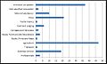
 Kilby Occupational Sector Graph, 2011.jpg 695 × 403; 83 KB
-
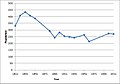 Kilby population time series 1811-2011.jpg 546 × 381; 39 KB
-
 Kilby United Reformed Church - geograph.org.uk - 3988159.jpg 1,024 × 768; 188 KB
-
 Kilby, Leicestershire - geograph.org.uk - 418030.jpg 640 × 362; 90 KB
-
 Leicester Road towards Fleckney - geograph.org.uk - 3591574.jpg 640 × 511; 58 KB
-
 Leicester Road towards Wigston - geograph.org.uk - 3591575.jpg 640 × 448; 35 KB
-
 Meadow at Wistow - geograph.org.uk - 3591576.jpg 640 × 473; 36 KB
-
 Narrow country lane to Newton Harcourt - geograph.org.uk - 4076950.jpg 1,600 × 1,236; 648 KB
-
 New Cottages in Foston - geograph.org.uk - 3673310.jpg 2,341 × 1,740; 1.24 MB
-
 North along Barley Lane towards Foston - geograph.org.uk - 3673381.jpg 2,199 × 1,663; 849 KB
-

-
 Occupational employment graph for Kilby, 1881.jpg 609 × 367; 51 KB
-

-
 Plaque at Wyggeston's Wood near Kilby - geograph.org.uk - 4667597.jpg 800 × 568; 181 KB
-
 Ploughed field west of Foston - geograph.org.uk - 3673234.jpg 2,711 × 2,055; 1.65 MB
-
 Public bridleway marker - geograph.org.uk - 3674949.jpg 1,600 × 1,200; 770 KB
-
 Public footpath near Wayside Farm - geograph.org.uk - 3673002.jpg 4,000 × 3,000; 3.34 MB
-
 Public footpath to Countesthorpe - geograph.org.uk - 5367419.jpg 800 × 638; 200 KB
-
 Public footpath to Wistow - geograph.org.uk - 3324238.jpg 2,803 × 2,414; 2.02 MB
-
 Road to Kilby Grange Farms - geograph.org.uk - 3324244.jpg 3,608 × 2,658; 2.6 MB
-
 Road to Soars Lodge Farm - geograph.org.uk - 4343682.jpg 640 × 380; 38 KB
-
 Row of poplar trees near Kilby - geograph.org.uk - 3673066.jpg 3,135 × 2,546; 2.47 MB
-
 Rubble strewn gate near Welford Road - geograph.org.uk - 5639429.jpg 800 × 527; 143 KB
-
 Seat at Wyggeston's Wood - geograph.org.uk - 4667603.jpg 800 × 482; 89 KB
-
 Sence Valley Farm at Kilby - geograph.org.uk - 5639434.jpg 800 × 498; 104 KB
-
 South Wigston visible across the fields - geograph.org.uk - 2887239.jpg 1,482 × 1,087; 595 KB
-
 Spinney Road - Welford Road junction - geograph.org.uk - 3673048.jpg 3,764 × 2,991; 3.33 MB
-
 St Bartholomew's church - geograph.org.uk - 5778037.jpg 4,000 × 3,000; 2.78 MB
-
 St Bartholomew's Church at Foston - geograph.org.uk - 5527648.jpg 800 × 494; 111 KB
-
 St Mary Magdalene Church, Kilby - geograph.org.uk - 2887314.jpg 2,314 × 1,514; 1.4 MB
-
 The Leicestershire village of Kilby - geograph.org.uk - 2887340.jpg 2,974 × 2,009; 2.42 MB
-
 The Main Street of Kilby - geograph.org.uk - 5639464.jpg 800 × 556; 89 KB
-
 The River Sence - geograph.org.uk - 209221.jpg 640 × 427; 131 KB
-

-
 Track to Foston Lodge Farm - geograph.org.uk - 4344723.jpg 640 × 480; 62 KB
-
 Tractor in a field near Foston - geograph.org.uk - 3673304.jpg 2,828 × 2,335; 2.15 MB
-
 Tributary of the River Sence - geograph.org.uk - 5664409.jpg 2,506 × 1,955; 1.7 MB
-
 Turnpike Farm near Welford Road - geograph.org.uk - 3674958.jpg 1,600 × 1,160; 473 KB
-

-
 View north towards Foston Hall Farm - geograph.org.uk - 3674780.jpg 1,600 × 1,245; 723 KB
-
 View to Foston Lodge Farm - geograph.org.uk - 2484593.jpg 1,757 × 1,458; 1.02 MB
-
 Welford Road (A5199) - geograph.org.uk - 4344721.jpg 640 × 480; 93 KB
-
 Welford Road (A5199) - geograph.org.uk - 4344724.jpg 640 × 480; 70 KB
-

-
 Welford Road towards Kilby Bridge - geograph.org.uk - 3673039.jpg 3,403 × 2,921; 3.19 MB
-
 Wistow Farmland - geograph.org.uk - 3988189.jpg 1,024 × 768; 245 KB
-
 Wistow Road borders The Nooks Country Park - geograph.org.uk - 5180007.jpg 2,000 × 1,500; 424 KB
-
 Wistow Road enters Kilby - geograph.org.uk - 5235197.jpg 2,000 × 1,500; 298 KB
-
 Wyggeston's Wood near Kilby - geograph.org.uk - 4667588.jpg 800 × 573; 118 KB
-
 Cattle grid near Wistow, Leicester - geograph.org.uk - 401194.jpg 640 × 484; 117 KB
-
 Cooks Lane near Wigston Harcourt - geograph.org.uk - 501172.jpg 640 × 460; 113 KB
-
 Farmland at Kilby - geograph.org.uk - 209213.jpg 640 × 427; 106 KB
-
 Farmland at Kilby Grange - geograph.org.uk - 209195.jpg 640 × 427; 74 KB
-
 Farmland near Kilby - geograph.org.uk - 401159.jpg 640 × 368; 80 KB
-
 Farmland near Kilby, Leicestershire - geograph.org.uk - 209191.jpg 640 × 427; 92 KB
-
 Farmland near Kilby, Leicestershire - geograph.org.uk - 209272.jpg 640 × 480; 102 KB
-
 Farmland near Wistow - geograph.org.uk - 401187.jpg 640 × 474; 127 KB
-
 Field, track and trees - geograph.org.uk - 183776.jpg 640 × 480; 112 KB
-
 Fleckney Grange Farm - geograph.org.uk - 209185.jpg 640 × 427; 71 KB
-
 Fleckney Road, Leicestershire - geograph.org.uk - 418028.jpg 640 × 500; 123 KB
-
 Foston Lane - geograph.org.uk - 209299.jpg 640 × 427; 76 KB
-

-
 Grand Union Canal near Newton Harcourt - geograph.org.uk - 401597.jpg 640 × 532; 108 KB
-
 Grand Union Canal near Newton Harcourt - geograph.org.uk - 401601.jpg 640 × 547; 106 KB
-
 Grand Union Canal near Newton Harcourt - geograph.org.uk - 401602.jpg 640 × 486; 113 KB
-

-
 Kilby Grange Farms, Leicestershire - geograph.org.uk - 418027.jpg 640 × 406; 83 KB
-
 Kilby, Leicestershire - geograph.org.uk - 209247.jpg 640 × 427; 82 KB
-
 Main Street Kilby near Leicester - geograph.org.uk - 401178.jpg 640 × 398; 92 KB
-
 Public footpath near Foston - geograph.org.uk - 401172.jpg 640 × 450; 93 KB
-
 Road junction on the A5199 - geograph.org.uk - 209258.jpg 640 × 427; 84 KB
-
 Road towards Wistow Park - geograph.org.uk - 184844.jpg 640 × 421; 72 KB
-
 Spot the triangulation pillar - geograph.org.uk - 220251.jpg 640 × 480; 105 KB
-
 The Meadows Riding Centre - geograph.org.uk - 209183.jpg 640 × 427; 105 KB
-
 Triangulation Pillar plate - geograph.org.uk - 220249.jpg 542 × 640; 121 KB
-
 Welford Road near Kilby - geograph.org.uk - 209277.jpg 640 × 427; 82 KB
-
 Wistow Road near Leicester - geograph.org.uk - 401183.jpg 640 × 437; 114 KB


_-_geograph.org.uk_-_4344721.jpg)
_-_geograph.org.uk_-_4344724.jpg)


