Category:Keefer Station Covered Bridge
Jump to navigation
Jump to search
| Object location | | View all coordinates using: OpenStreetMap |
|---|
 | |||||
| Upload media | |||||
| Instance of | |||||
|---|---|---|---|---|---|
| Location | Pennsylvania | ||||
| Crosses | |||||
| Heritage designation |
| ||||
 | |||||
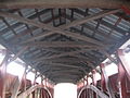
English: Keefer Station Covered Bridge, originally built in 1888 over Shamokin Creek in Upper Augusta Township in Northumberland County, Pennsylvania, USA.
|
This is a category about a place or building that is listed on the National Register of Historic Places in the United States of America. Its reference number is 79002313. |
Media in category "Keefer Station Covered Bridge"
The following 19 files are in this category, out of 19 total.
-
 Keefer Station Covered Bridge 1.jpg 3,648 × 2,736; 2.38 MB
-
 Keefer Station Covered Bridge 10.jpg 5,427 × 2,637; 1.29 MB
-
 Keefer Station Covered Bridge 11.jpg 6,313 × 2,732; 1.52 MB
-
 Keefer Station Covered Bridge 12.jpg 3,648 × 2,736; 2.36 MB
-
 Keefer Station Covered Bridge 13.jpg 5,077 × 3,463; 2.57 MB
-
 Keefer Station Covered Bridge 14.jpg 5,560 × 2,673; 2.2 MB
-
 Keefer Station Covered Bridge 15.jpg 3,648 × 2,736; 2.34 MB
-
 Keefer Station Covered Bridge 16.jpg 3,648 × 2,736; 3.47 MB
-
 Keefer Station Covered Bridge 17.jpg 3,648 × 2,736; 3.12 MB
-
 Keefer Station Covered Bridge 18.jpg 3,648 × 2,736; 1.85 MB
-
 Keefer Station Covered Bridge 19.jpg 3,648 × 2,736; 2.58 MB
-
 Keefer Station Covered Bridge 2.jpg 3,648 × 2,736; 3.62 MB
-
 Keefer Station Covered Bridge 3.jpg 3,648 × 2,736; 3.46 MB
-
 Keefer Station Covered Bridge 4.jpg 3,648 × 2,736; 3.72 MB
-
 Keefer Station Covered Bridge 5.jpg 3,648 × 2,736; 3.84 MB
-
 Keefer Station Covered Bridge 6.jpg 3,648 × 2,736; 1.59 MB
-
 Keefer Station Covered Bridge 7.jpg 6,652 × 3,548; 2.56 MB
-
 Keefer Station Covered Bridge 8.jpg 3,648 × 2,736; 2.11 MB
-
 Keefer Station Covered Bridge 9.jpg 3,648 × 2,736; 1.9 MB


