Category:Kath. Pfarrkirche St. Veit/Gegend
Jump to navigation
Jump to search
| Object location | | View all coordinates using: OpenStreetMap |
|---|
church building in Mühlen, Austria   | |||||
| Upload media | |||||
| Instance of | |||||
|---|---|---|---|---|---|
| Location | Sankt Veit in der Gegend, Mühlen, Murau District, Styria, Austria | ||||
| Street address |
| ||||
| Heritage designation | |||||
 | |||||
Subcategories
This category has the following 2 subcategories, out of 2 total.
Media in category "Kath. Pfarrkirche St. Veit/Gegend"
The following 4 files are in this category, out of 4 total.
-
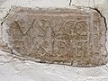 Kirche St Veit in der Gegend Römerinschrift.jpg 4,608 × 3,456; 3.26 MB
-
 Kirche St Veit in der Gegend Römerrelief.jpg 4,608 × 3,456; 3.5 MB
-
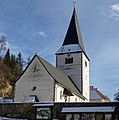 Kirche St Veit in der Gegend.jpg 3,163 × 3,181; 1.4 MB
-
 StVeitKathPfarrkirche1.jpg 3,038 × 2,224; 2.51 MB


