Category:Kasteel Warmond
Jump to navigation
Jump to search
| Object location | | View all coordinates using: OpenStreetMap |
|---|
 | |||||
| Upload media | |||||
| Instance of | |||||
|---|---|---|---|---|---|
| Part of |
| ||||
| Location | Warmond, South Holland, Netherlands | ||||
| Street address |
| ||||
| Located on street |
| ||||
| Heritage designation |
| ||||
 | |||||
Nederlands: Huis te warmond
|
This is a category about rijksmonumentcomplex number 511218
|
Landhuis:
|
This is a category about rijksmonument number 511219
|
Historische tuin- en parkaanleg:
|
This is a category about rijksmonument number 511220
|
Toegangshek:
|
This is a category about rijksmonument number 511221
|
Kanonnen:
|
This is a category about rijksmonument number 511222
|
Portierswoning:
|
This is a category about rijksmonument number 511223
|
Hekpijlers:
|
This is a category about rijksmonument number 511224
|
Oranjerie:
|
This is a category about rijksmonument number 511225
|
Koetshuis:
|
This is a category about rijksmonument number 511226
|
Speelzaal:
|
This is a category about rijksmonument number 511227
|
| Address |
|
Subcategories
This category has only the following subcategory.
K
- Kasteel Warmond in Madurodam (3 F)
Media in category "Kasteel Warmond"
The following 75 files are in this category, out of 75 total.
-
 2. Het Huis te Warmond toegang.jpg 1,617 × 1,080; 1.01 MB
-
 3. Het Huis te Warmond achteraanzicht.jpg 1,617 × 1,080; 1.08 MB
-
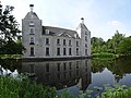
 4. Het Huis te Warmond weerspiegeling.jpg 1,617 × 1,080; 634 KB
-
 Achtergevel - Warmond - 20249799 - RCE.jpg 1,200 × 959; 250 KB
-
 Achtergevel - Warmond - 20249811 - RCE.jpg 1,200 × 1,118; 222 KB
-
 Achtergevel Huis Warmond - Warmond - 20249800 - RCE.jpg 959 × 1,200; 214 KB
-
 Achterzijde - Warmond - 20249820 - RCE.jpg 1,200 × 949; 307 KB
-
 Achterzijde, Huis Warmond - Warmond - 20249798 - RCE.jpg 1,200 × 851; 158 KB
-
 Detail hekpijler van toegangshek bij tuinmanswoning. - Warmond - 20249831 - RCE.jpg 1,200 × 1,198; 368 KB
-
 Detail hekpijler van toegangshek bij tuinmanswoning. - Warmond - 20249832 - RCE.jpg 1,193 × 1,200; 333 KB
-
 Detail hekpijler van toegangshek bij tuinmanswoning. - Warmond - 20249833 - RCE.jpg 1,195 × 1,200; 338 KB
-
 Detail hekpijler van toegangshek bij tuinmanswoning. - Warmond - 20249834 - RCE.jpg 1,200 × 1,197; 370 KB
-
 Detail hekpijler van toegangshek bij tuinmanswoning. - Warmond - 20249835 - RCE.jpg 1,186 × 1,200; 262 KB
-
 Detail hekpijler van toegangshek bij tuinmanswoning. - Warmond - 20249836 - RCE.jpg 1,195 × 1,200; 275 KB
-
 Detail hekpijler van toegangshek bij tuinmanswoning. - Warmond - 20249837 - RCE.jpg 1,200 × 1,195; 313 KB
-
 Exterieur - Warmond - 20249816 - RCE.jpg 1,200 × 816; 224 KB
-
 Exterieur - Warmond - 20249819 - RCE.jpg 1,200 × 950; 268 KB
-
 Exterieur overzicht - Warmond - 20249822 - RCE.jpg 1,200 × 807; 210 KB
-
 Exterieur overzicht - Warmond - 20249823 - RCE.jpg 1,200 × 804; 236 KB
-
 Front, Huis Warmond - Warmond - 20249797 - RCE.jpg 1,200 × 826; 175 KB
-
 Gedeelte toegangshek bij tuinmanswoning - Warmond - 20249827 - RCE.jpg 1,200 × 1,197; 488 KB
-

-
 Gezicht op Huis Warmond, 1611 Het Huis te Warmont 1611 (titel op object), RP-P-OB-73.437.jpg 4,434 × 3,220; 2.19 MB
-

-

-

-
 Gravure - Warmond - 20249795 - RCE.jpg 1,200 × 873; 264 KB
-
 Gravure - Warmond - 20249796 - RCE.jpg 1,200 × 876; 257 KB
-
 Hek - Warmond - 20249817 - RCE.jpg 1,200 × 810; 255 KB
-
 Hekpijler van toegangshek bij tuinmanswoning. - Warmond - 20249828 - RCE.jpg 1,192 × 1,200; 490 KB
-
 Hekpijler van toegangshek bij tuinmanswoning. - Warmond - 20249829 - RCE.jpg 1,192 × 1,200; 450 KB
-
 Hekpijler van toegangshek bij tuinmanswoning. - Warmond - 20249830 - RCE.jpg 1,190 × 1,200; 350 KB
-
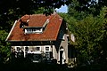
 Herenweg 143-145, Warmond.JPG 2,856 × 1,717; 2.25 MB
-
 Herenweg 147, Warmond.JPG 3,072 × 2,048; 3.34 MB
-
 Huis te Warmond.jpg 1,536 × 1,047; 614 KB
-
 Huis Warmond Gezicht van huis te Warmond, gezien vanuit het zuiden, RP-T-1891-A-2419.jpg 6,418 × 4,244; 3.44 MB
-
 Huis Warmond, interieur - Warmond - 20249804 - RCE.jpg 1,200 × 828; 190 KB
-
 Huis Warmond, interieur - Warmond - 20249805 - RCE.jpg 1,200 × 851; 192 KB
-
 Huis Warmond, interieur - Warmond - 20249806 - RCE.jpg 883 × 1,200; 131 KB
-
 Huis Warmond, interieur - Warmond - 20249807 - RCE.jpg 892 × 1,200; 141 KB
-
 Interieur, hal met trap - Warmond - 20249814 - RCE.jpg 894 × 1,200; 164 KB
-
 Jan Beerstraten - Warmond Castle in a Winter Landscape - Google Art Project.jpg 2,857 × 2,060; 2.86 MB
-
 Kanon - Huys te Warmont.JPG 3,072 × 2,048; 2.11 MB
-
 Kasteel in een landschap Landschappen met gebouwen (serietitel), RP-P-OB-2536.jpg 6,680 × 4,674; 4.88 MB
-
 Kasteel in een landschap.jpeg 2,500 × 1,749; 814 KB
-
 Kasteel naar oude tekening - Warmond - 20249793 - RCE.jpg 1,200 × 787; 241 KB
-
 Kasteel Warmond achterzijde.jpg 6,631 × 4,971; 8.03 MB
-
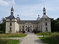 Kasteel Warmond voorzijde.jpg 3,814 × 2,859; 2.88 MB
-
 Kasteel Warmond, exterieur zijaanzicht - Warmond - 20249803 - RCE.jpg 959 × 1,200; 295 KB
-
 Kasteel Warmond, zijaanzicht - Warmond - 20249802 - RCE.jpg 1,200 × 959; 225 KB
-
 Kasteel Warmond, zijgevel - Warmond - 20249801 - RCE.jpg 959 × 1,200; 244 KB
-
 Landschapstuin in bos - Warmond - 20249821 - RCE.jpg 1,200 × 954; 398 KB
-
 Linker zijvleugel met toren en gracht - Warmond - 20249813 - RCE.jpg 894 × 1,200; 223 KB
-
 Ontwerp kasteel door De Bray in Archief Haarlem - Warmond - 20249791 - RCE.jpg 1,200 × 890; 232 KB
-
 Ontwerp kasteel door De Bray in Archief Haarlem - Warmond - 20249792 - RCE.jpg 888 × 1,200; 246 KB
-
 Oost-gevel - Warmond - 20249808 - RCE.jpg 1,200 × 1,193; 293 KB
-
 Oost-gevel - Warmond - 20249809 - RCE.jpg 1,200 × 1,200; 335 KB
-
 Oost-gevel - Warmond - 20249810 - RCE.jpg 1,200 × 1,200; 391 KB
-
 Oranjerie - Huys te Warmont.JPG 3,072 × 2,048; 3.12 MB
-
 Overzicht - Warmond - 20365870 - RCE.jpg 1,200 × 956; 357 KB
-
 Overzicht toegangshek bij tuinmanswoning - Warmond - 20249824 - RCE.jpg 1,200 × 1,195; 465 KB
-
 Overzicht toegangshek bij tuinmanswoning - Warmond - 20249825 - RCE.jpg 1,200 × 1,200; 505 KB
-
 Overzicht toegangshek bij tuinmanswoning - Warmond - 20249826 - RCE.jpg 1,188 × 1,200; 450 KB
-
 Overzicht voorgevel en zijvleugels met torens - Warmond - 20249812 - RCE.jpg 1,200 × 894; 216 KB
-
 Pentekening van Roghman - Warmond - 20249815 - RCE.jpg 1,200 × 787; 170 KB
-
 Sundial Huis te Warmond 11-5-2006 17-20-22.JPG 2,272 × 1,704; 1.44 MB
-
 Toegangshek - Huys te Warmont.JPG 3,072 × 2,048; 2.67 MB
-
 Tuinmanswoning, exterieur - Warmond - 20249818 - RCE.jpg 1,200 × 806; 258 KB
-

-
 Warmond Bos huis bij ingang.jpg 3,648 × 2,736; 5.63 MB
-
 Warmond Huys te Warmond bos.jpg 2,736 × 3,648; 5.26 MB
-
 Warmond Huys te Warmond.jpg 3,648 × 2,736; 4.46 MB
-
 Warmond kastele.jpg 438 × 500; 176 KB
-
 Woodrot as seen on dead tree in Warmond (1).JPG 2,000 × 3,008; 2.83 MB
-
 Woodrot as seen on dead tree in Warmond (2).JPG 2,000 × 3,008; 3.1 MB


,_RP-P-AO-10-49C-B-1.jpg)
,_RP-P-OB-73.437.jpg)
,_RP-P-AO-10-49C-B-3.jpg)
,_RP-P-OB-73.438.jpg)
,_RP-P-OB-73.439.jpg)


,_RP-P-OB-2536.jpg)


.JPG)
.JPG)