Category:Kapelle St. Leonhard (Landschlacht)
Jump to navigation
Jump to search
| Object location | | View all coordinates using: OpenStreetMap |
|---|
  | |||||
| Upload media | |||||
| Instance of | |||||
|---|---|---|---|---|---|
| Part of | |||||
| Location |
| ||||
| Street address |
| ||||
| Heritage designation |
| ||||
 | |||||
|
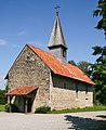
This is a category about a cultural property of national significance in Switzerland with KGS number 5119
|
Subcategories
This category has only the following subcategory.
Media in category "Kapelle St. Leonhard (Landschlacht)"
The following 18 files are in this category, out of 18 total.
-
 Landschlacht, Kapelle St. Leonhard 02.jpg 2,258 × 1,500; 946 KB
-
 LandschlachtChapelOrchard.JPG 3,568 × 2,376; 5.56 MB
-
 LandschlachtKapelle1.JPG 2,704 × 2,376; 4.21 MB
-
 LandschlachtKapelleTurm.JPG 2,376 × 3,568; 5.34 MB
-
 LandschlchtChapelE.JPG 2,237 × 3,215; 4.2 MB
-
 LandschlchtChapelNE.JPG 2,906 × 2,243; 3.83 MB
-
 LandschlchtChapelNW.JPG 3,097 × 2,376; 4.8 MB
-
 LandschlchtChapelWindowS.JPG 2,376 × 3,568; 5.59 MB
-
 LandschlchtKapelleEingang.JPG 2,376 × 3,225; 5.07 MB
-
 LandschlchtKapelleFenster2innen.JPG 2,376 × 3,568; 7 MB
-
 LandschlchtKapellenfenster1.JPG 1,840 × 3,078; 4.55 MB
-
 LandschlchtKapellenfenster2.JPG 2,162 × 3,568; 5.02 MB
-
 LandschlchtKapellenfenster2innen.JPG 2,376 × 3,568; 5.68 MB
-
 LandschlchtKapellenfenter1innen.JPG 2,376 × 3,568; 6.01 MB
-
 LandschlchtKapellenfesterNord.JPG 1,549 × 2,822; 3.31 MB
-
 LandschlchtKapelleNord.JPG 2,448 × 2,263; 3.35 MB
-
 St leonhard chapel.jpg 893 × 1,089; 820 KB
-
 St.-Leonhards-Kapelle in Landschlacht TG.jpg 4,200 × 3,780; 10.02 MB


