Category:Köppen climate classification maps of Venezuela
Jump to navigation
Jump to search
Media in category "Köppen climate classification maps of Venezuela"
The following 13 files are in this category, out of 13 total.
-
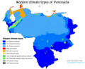 Venezuela Köppen.png 4,782 × 3,891; 444 KB
-
 Koppen-Geiger Map VEN future.svg 1,321 × 850; 1.07 MB
-
 Koppen-Geiger Map VEN present.svg 1,321 × 850; 1.07 MB
-
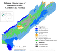 Köppen Andes Merida Cordillera.png 5,845 × 5,100; 1.07 MB
-
 Köppen Andes Perija.png 4,194 × 5,100; 632 KB
-
 Köppen Cordillera Costa Central.png 6,574 × 4,176; 826 KB
-
 Köppen Cordillera Costa Oriental.png 6,574 × 3,364; 750 KB
-
 Köppen Guayana.png 6,574 × 5,100; 1.05 MB
-
 Köppen Llanos.png 6,565 × 3,130; 568 KB
-
 Köppen Maracaibo Lowlands.png 3,502 × 4,997; 541 KB
-
 Köppen Orinoco Delta.png 6,459 × 4,721; 697 KB
-
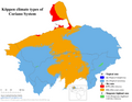 Köppen Sistema Coriano.png 6,557 × 5,100; 972 KB
-
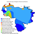 Venezuela map of Köppen climate classification.svg 1,900 × 1,900; 273 KB


