Category:June 2013 in Kent
Jump to navigation
Jump to search
Ceremonial counties of England: Bedfordshire · Berkshire · Buckinghamshire · Cambridgeshire · Cheshire · Cornwall · Cumbria · Derbyshire · Devon · Dorset · Durham · East Riding of Yorkshire · East Sussex · Essex · Gloucestershire · Greater London · Greater Manchester · Hampshire · Herefordshire · Hertfordshire · Isle of Wight · Kent · Lancashire · Leicestershire · Lincolnshire · Merseyside · Norfolk · North Yorkshire · Northamptonshire · Nottinghamshire · Oxfordshire · Somerset · South Yorkshire · Staffordshire · Suffolk · Surrey · Tyne and Wear · Warwickshire · West Midlands · West Sussex · West Yorkshire · Wiltshire ·
City-counties: Bristol ·
Former historic counties:
Other former counties:
City-counties: Bristol ·
Former historic counties:
Other former counties:
Deutsch: Bilder, die im Juni 2013 in Kent aufgenommen worden sind. Bitte beachten Sie, dass dies weder das Datum des Uploads noch das Datum des Scannens eines Fotos ist.
English: Images/pictures taken in Kent during June 2013. Note this is not the date of the upload, nor the date a photo was scanned.
Español: Fotografías o imágenes tomadas en Kent durante junio 2013. No es la fecha de subida ni escaneo, sino la fecha en que las fotografías o imágenes se crearon.
Esperanto: Bildoj faritaj en Kent en junio 2013. Tio ne estas la dato, kiam la bildoj estis alŝutitaj aŭ skanitaj.
Français : Photographies ou images prises en Kent durant juin 2013. Ce n'est pas la date du téléchargement ou du scan.
Galego: Fotografías ou imaxes tomadas en Kent durante xuño 2013. Non é a data de subida nin escaneamento, senón a data na que se crearon as fotografías ou imaxes.
Italiano: Fotografie o immagini scattate a Kent nel giugno 2013. Nota bene: la data non si riferisce né a quella di upload né a quella in cui la foto è stata digitalizzata.
Norsk bokmål: Bilder tatt i Kent i løpet av juni 2013. Merk at dette ikke er datoen for opplasting, eller når et bilde har blitt skannet.
Norsk nynorsk: Bilete teke i Kent i løpet av juni 2013. Merk at dette ikkje er datoen for opplasting, eller når eit bilete har vorte skanna.
Русский: Изображения, сделанные в Kent в течение июнь 2013 (не дата загрузки изображения).
Українська: Зображення, зроблені в Kent протягом червень 2013. Зауважте, що це не дата завантаження чи дата сканування фотографії.
| June 2012 | ← | June 2013 | → | June 2014 | |||||||
| Jan | Feb | Mar | Apr | May | Jun | Jul | Aug | Sep | Oct | Nov | Dec |
| 77 | 4 | 65 | 64 | 164 | 186 | 56 | 66 | 23 | 72 | 248 | 25 |
|---|---|---|---|---|---|---|---|---|---|---|---|
Subcategories
This category has only the following subcategory.
Media in category "June 2013 in Kent"
The following 185 files are in this category, out of 185 total.
-
 10 - 12, Garden St - geograph.org.uk - 3711424.jpg 640 × 430; 67 KB
-
 18, Garden St - geograph.org.uk - 3711427.jpg 640 × 430; 73 KB
-
 18, Goods Station Rd - geograph.org.uk - 3702988.jpg 640 × 430; 75 KB
-
 22, Garden Street - geograph.org.uk - 3711431.jpg 640 × 434; 72 KB
-
 A267 - geograph.org.uk - 3651589.jpg 640 × 430; 103 KB
-
 Addison Rd - geograph.org.uk - 3720433.jpg 640 × 430; 58 KB
-
 Arriva Bus Depot - geograph.org.uk - 3657566.jpg 640 × 430; 58 KB
-
 Art Exhibition - geograph.org.uk - 3651532.jpg 640 × 430; 86 KB
-
 Bayhall House - geograph.org.uk - 3711456.jpg 640 × 430; 84 KB
-
 Belgrove House - geograph.org.uk - 3657406.jpg 640 × 430; 99 KB
-
 Belgrove Terrace - geograph.org.uk - 3657405.jpg 640 × 430; 114 KB
-
 Birken Rd - geograph.org.uk - 3720405.jpg 640 × 430; 96 KB
-
 Blacks, Monson Rd - geograph.org.uk - 3703016.jpg 640 × 430; 65 KB
-
 Blatchington Rd - geograph.org.uk - 3657366.jpg 640 × 430; 87 KB
-
 Boat house, Dunorlan Lake - geograph.org.uk - 3711542.jpg 640 × 430; 95 KB
-
 BP filling station, St John's Rd - geograph.org.uk - 3657570.jpg 640 × 430; 55 KB
-
 Bromley Villas - geograph.org.uk - 3711455.jpg 640 × 430; 80 KB
-
 Bryan's the Barber - geograph.org.uk - 3702960.jpg 640 × 430; 73 KB
-
 BT Building, St John's Rd - geograph.org.uk - 3657562.jpg 640 × 421; 57 KB
-
 Built in 1951 - geograph.org.uk - 3720401.jpg 640 × 430; 82 KB
-
 Caffè Nero - geograph.org.uk - 3651456.jpg 640 × 430; 77 KB
-
 Calverley House - geograph.org.uk - 3703022.jpg 640 × 494; 68 KB
-
 Calverley Park Crescent - geograph.org.uk - 3711434.jpg 640 × 430; 86 KB
-
 Car park, Dunorlan Park - geograph.org.uk - 3720012.jpg 640 × 430; 92 KB
-
 Chalybeate Spring, Dunorlan Park - geograph.org.uk - 3720004.jpg 640 × 430; 99 KB
-
 Church of Christ - geograph.org.uk - 3684147.jpg 640 × 430; 75 KB
-
 Church of Christ - geograph.org.uk - 3775712.jpg 640 × 430; 56 KB
-
 Church of Christ, Commercial Rd - geograph.org.uk - 3702964.jpg 640 × 430; 79 KB
-
 Clarendon Way - geograph.org.uk - 3651581.jpg 640 × 430; 66 KB
-
 Closed establishment - geograph.org.uk - 3711405.jpg 640 × 430; 77 KB
-
 Colonnade, The Pantiles - geograph.org.uk - 3651520.jpg 640 × 430; 99 KB
-
 Cooling Castle gatehouse.jpg 4,000 × 3,000; 6.86 MB
-
 Corn Exchange Garage - geograph.org.uk - 3702978.jpg 640 × 430; 59 KB
-
 Cosmo - geograph.org.uk - 3657530.jpg 640 × 430; 70 KB
-
 Costcutter, Pencester Road - geograph.org.uk - 3530172.jpg 718 × 538; 110 KB
-
 Cul-de-sac off Sandhurst Rd - geograph.org.uk - 3720404.jpg 640 × 430; 92 KB
-
 Cumberland Walk - geograph.org.uk - 3657368.jpg 640 × 430; 125 KB
-
 Cumberland Walk - geograph.org.uk - 3657375.jpg 640 × 430; 113 KB
-
 Dainton House - geograph.org.uk - 3702967.jpg 640 × 430; 86 KB
-
 Duke of York - geograph.org.uk - 3651514.jpg 640 × 430; 80 KB
-
 Dunorlan Park - geograph.org.uk - 3711540.jpg 640 × 430; 94 KB
-
 EKR bridge into Richborough 1306 01.jpg 4,000 × 3,000; 7.17 MB
-
 EKR bridge into Richborough 1306 02.jpg 4,000 × 3,000; 5.24 MB
-

-
 Ex-railway bridge, Cumberland Walk - geograph.org.uk - 3657371.jpg 640 × 430; 107 KB
-
 Fixing a broken sewer pipe in Cannon Street - geograph.org.uk - 3518042.jpg 1,077 × 807; 183 KB
-
 Former entrance gates to Whitstable Harbour Station (geograph 3545632).jpg 1,142 × 856; 174 KB
-
 Formerly a Natwest Bank - geograph.org.uk - 3657541.jpg 640 × 430; 75 KB
-
 Fountain and water trough - geograph.org.uk - 3711437.jpg 640 × 433; 87 KB
-
 Gasholder, High Brooms - geograph.org.uk - 3684141.jpg 640 × 430; 63 KB
-
 Gasholder, High Brooms - geograph.org.uk - 3720434.jpg 640 × 430; 88 KB
-
 Glendale Villas - geograph.org.uk - 3711471.jpg 640 × 430; 93 KB
-
 Grampian Close - geograph.org.uk - 3720391.jpg 640 × 430; 76 KB
-
 Grassy meadow - geograph.org.uk - 3711485.jpg 640 × 430; 60 KB
-
 Grosvenor Park - geograph.org.uk - 3657537.jpg 640 × 430; 67 KB
-
 Grove Tavern - geograph.org.uk - 3657402.jpg 640 × 430; 74 KB
-
 GWR No 1638.jpg 4,000 × 2,248; 5.23 MB
-
 Haslett Close - geograph.org.uk - 3702954.jpg 640 × 430; 60 KB
-
 Heron Manor and Monkton Cottage, Chilham 01.jpg 2,816 × 2,112; 1.48 MB
-
 Heron Manor and Monkton Cottage, Chilham 02.jpg 2,112 × 2,816; 1.45 MB
-
 Heron Manor and Monkton Cottage, Chilham 03.jpg 2,816 × 2,112; 1.46 MB
-
 High Brooms Gasholder - geograph.org.uk - 3720432.jpg 640 × 430; 95 KB
-
 House on Upper Cumberland Walk - geograph.org.uk - 3657370.jpg 640 × 430; 96 KB
-
 House, Linden Park Rd - geograph.org.uk - 3651568.jpg 640 × 430; 87 KB
-
 Keston Lodge - geograph.org.uk - 3711439.jpg 640 × 430; 73 KB
-
 King Charles School - geograph.org.uk - 3651487.jpg 640 × 430; 82 KB
-
 Kingswood Villas - geograph.org.uk - 3711463.jpg 640 × 443; 78 KB
-
 Lodge, Pembury Rd - geograph.org.uk - 3720025.jpg 640 × 430; 112 KB
-
 Lydd station 1306 01.jpg 4,000 × 3,000; 6.6 MB
-
 Lydd station 1306 02.jpg 4,000 × 3,000; 6.39 MB
-
 Lydd station 1306 03.jpg 4,000 × 3,000; 6.48 MB
-
 Lydd station 1306 04.jpg 4,000 × 3,000; 7.03 MB
-
 Lydd station 1306 05.jpg 4,000 × 3,000; 7.08 MB
-
 Lydd station 1306 06.jpg 4,000 × 3,000; 6.45 MB
-
 Lydd station 1306 07.jpg 4,000 × 3,000; 6.98 MB
-
 Marsh Farm Road level crossing - Minster (2) - geograph.org.uk - 3547435.jpg 1,250 × 813; 1.19 MB
-
 Meadow Rd car park - geograph.org.uk - 3702989.jpg 640 × 430; 91 KB
-
 Mercer St - geograph.org.uk - 3702971.jpg 640 × 430; 88 KB
-
 Miles Garage, Mount Sion - geograph.org.uk - 3657397.jpg 640 × 430; 66 KB
-
 Nevill Terrace - geograph.org.uk - 3651537.jpg 640 × 430; 86 KB
-
 Nevill Terrace - geograph.org.uk - 3651563.jpg 640 × 430; 71 KB
-
 New flats by the railway line - geograph.org.uk - 3702957.jpg 640 × 430; 61 KB
-
 New houses, Connaught Park - geograph.org.uk - 3720431.jpg 640 × 430; 64 KB
-
 Next, Camden Rd - geograph.org.uk - 3703033.jpg 640 × 430; 103 KB
-
 No 3 Bodiam Arriving For Duty.jpg 1,775 × 3,352; 4.23 MB
-
 No. 14 Charwelton At Rolvenden Yard.jpg 3,903 × 1,975; 4.51 MB
-
 North Farm Rd - geograph.org.uk - 3684142.jpg 640 × 430; 73 KB
-
 North Farm Rd - geograph.org.uk - 3775707.jpg 640 × 430; 53 KB
-
 Old advert, Stephen's St - geograph.org.uk - 3702953.jpg 640 × 430; 92 KB
-
 Old chapel - geograph.org.uk - 3651483.jpg 430 × 640; 73 KB
-
 Part of Calverley New Town - geograph.org.uk - 3711443.jpg 640 × 430; 65 KB
-
 Pizza Express, High Street - geograph.org.uk - 3651473.jpg 640 × 430; 72 KB
-
 Pizza Hut Delivery - geograph.org.uk - 3657574.jpg 640 × 430; 63 KB
-
 Post Office - geograph.org.uk - 3702991.jpg 640 × 430; 70 KB
-
 Prince of Wales - geograph.org.uk - 3703026.jpg 640 × 430; 67 KB
-
 Private Road - geograph.org.uk - 3720013.jpg 640 × 430; 94 KB
-
 Pylon by Sandhurst Rd - geograph.org.uk - 3720421.jpg 430 × 640; 59 KB
-
 Quantock Close - geograph.org.uk - 3720390.jpg 640 × 430; 99 KB
-
 Railway shed, Spa Valley Railway - geograph.org.uk - 3651554.jpg 640 × 430; 87 KB
-
 Recall, Goods Station Rd - geograph.org.uk - 3702969.jpg 640 × 430; 80 KB
-
 Red Lodge - geograph.org.uk - 3720033.jpg 640 × 430; 89 KB
-
 Renovation, Tunnel St - geograph.org.uk - 3702974.jpg 640 × 430; 57 KB
-
 Robin Hood - geograph.org.uk - 3720407.jpg 640 × 430; 97 KB
-
 Rodmell Rd - geograph.org.uk - 3657373.jpg 640 × 430; 98 KB
-
 Rodmell Rd - geograph.org.uk - 3657374.jpg 640 × 430; 108 KB
-
 Rodmell Rd - geograph.org.uk - 3657377.jpg 640 × 430; 101 KB
-
 Rodmell Rise - geograph.org.uk - 3657358.jpg 640 × 430; 71 KB
-
 Rose ^ Crown - geograph.org.uk - 3657535.jpg 640 × 430; 73 KB
-
 Roundabout, North Farm Rd - geograph.org.uk - 3775710.jpg 640 × 430; 76 KB
-
 Route of the old railway - geograph.org.uk - 3651571.jpg 640 × 430; 88 KB
-
 Sandhurst Park - geograph.org.uk - 3720413.jpg 640 × 430; 86 KB
-
 Sandhurst Park - geograph.org.uk - 3720428.jpg 640 × 430; 89 KB
-
 Silverdale Day Nursery - geograph.org.uk - 3775716.jpg 640 × 430; 93 KB
-
 Silverdale House - geograph.org.uk - 3684151.jpg 640 × 430; 72 KB
-
 Sladen Chambers - geograph.org.uk - 3651440.jpg 640 × 430; 83 KB
-
 St John Ambulance, Silverdale Rd - geograph.org.uk - 3775715.jpg 640 × 430; 76 KB
-
 St John's Yard - geograph.org.uk - 3657575.jpg 640 × 430; 64 KB
-
 St Phillips Court - geograph.org.uk - 3720411.jpg 640 × 377; 80 KB
-
 Teddies Nursery - geograph.org.uk - 3657572.jpg 640 × 430; 76 KB
-
 Telecommunications mast, High Brooms - geograph.org.uk - 3614261.jpg 430 × 640; 41 KB
-
 Terrace and steps - geograph.org.uk - 3719995.jpg 640 × 430; 99 KB
-
 Terrace and steps - geograph.org.uk - 3719997.jpg 640 × 430; 93 KB
-
 Terraced houses, Tunnel Rd - geograph.org.uk - 3702981.jpg 640 × 430; 74 KB
-
 Tesco Metro - geograph.org.uk - 3657533.jpg 640 × 430; 57 KB
-
 The 11.40 To Tenterden.jpg 2,748 × 2,248; 3.34 MB
-
 The Bedford - geograph.org.uk - 3651453.jpg 640 × 430; 87 KB
-
 The Beeches - geograph.org.uk - 3720393.jpg 640 × 430; 94 KB
-
 The Black Pig - geograph.org.uk - 3657431.jpg 640 × 430; 59 KB
-

-
 The Compasses - geograph.org.uk - 3657399.jpg 640 × 430; 86 KB
-
 The Crystal Palace - geograph.org.uk - 3711395.jpg 640 × 430; 82 KB
-
 The former Calverley School - geograph.org.uk - 3712563.jpg 640 × 403; 72 KB
-
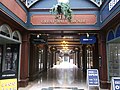
 The Great Hall Arcade - geograph.org.uk - 3657451.jpg 640 × 430; 72 KB
-
 The Great Hall Arcade, Tunbridge Wells - geograph.org.uk - 3512500.jpg 4,288 × 3,216; 4.76 MB
-
 The Grove - geograph.org.uk - 3657408.jpg 640 × 430; 116 KB
-
 The Grove - geograph.org.uk - 3657409.jpg 640 × 430; 127 KB
-
 The International Tile Store - geograph.org.uk - 3702980.jpg 640 × 430; 90 KB
-
 The Last Post - geograph.org.uk - 3702990.jpg 640 × 430; 65 KB
-
 The Lodge, Sandhurst Rd - geograph.org.uk - 3720392.jpg 640 × 430; 80 KB
-
 The Mead School - geograph.org.uk - 3651587.jpg 640 × 430; 79 KB
-
 The Pantiles - geograph.org.uk - 3651508.jpg 640 × 430; 94 KB
-
 The Pantiles Vintry - geograph.org.uk - 3651503.jpg 640 × 430; 84 KB
-
 The Ragged Trousers - geograph.org.uk - 3651524.jpg 640 × 430; 88 KB
-
 The Royal Oak - geograph.org.uk - 3711445.jpg 640 × 430; 58 KB
-
 The Salvation Army - geograph.org.uk - 3711447.jpg 640 × 430; 65 KB
-
 The Tunbridge Wells Hotel - geograph.org.uk - 3651529.jpg 640 × 430; 93 KB
-
 Travis Perkins, Goods Station Rd - geograph.org.uk - 3702982.jpg 640 × 430; 73 KB
-
 Tree lined road - geograph.org.uk - 3720419.jpg 640 × 430; 111 KB
-
 Tunbridge - geograph-3651540-by-N-Chadwick.jpg 640 × 430; 71 KB
-
 Tunbridge Wells Farmers Market - geograph.org.uk - 3703005.jpg 640 × 430; 96 KB
-
 Tunbridge Wells Farmers Market - geograph.org.uk - 3703008.jpg 640 × 430; 101 KB
-
 Tunbridge Wells High Rocks Lane 4062.JPG 3,264 × 2,448; 3.87 MB
-
 Tunbridge Wells High Rocks Lane 4063.JPG 3,264 × 2,448; 3.24 MB
-
 Tunbridge Wells High Rocks Walk 4070.JPG 3,264 × 2,448; 3.69 MB
-
 Tunbridge Wells War Memorial - geograph.org.uk - 3702997.jpg 640 × 430; 86 KB
-
 Upper Cumberland Walk - geograph.org.uk - 3657367.jpg 640 × 430; 100 KB
-
 VC holders, Tunbridge Wells - geograph.org.uk - 3711481.jpg 640 × 430; 89 KB
-
 Victoria Grove, Dunorlan Park - geograph.org.uk - 3711476.jpg 640 × 430; 90 KB
-
 Victoria Grove, Dunorlan Park - geograph.org.uk - 3711482.jpg 640 × 430; 83 KB
-

-

-
 Wellington Rocks Tunbridge Wells Common 4007.JPG 3,264 × 2,448; 3.61 MB
-
 Wellington Rocks Tunbridge Wells Common 4008.JPG 3,264 × 2,448; 3.68 MB
-
 Wellington Rocks Tunbridge Wells Common 4009.JPG 3,264 × 2,448; 3.7 MB
-
 Wellington Rocks Tunbridge Wells Common 4012.JPG 3,264 × 2,448; 3.67 MB
-
 Wellington Rocks Tunbridge Wells Common 4014.JPG 3,264 × 2,448; 3.37 MB
-
 Wellington Rocks Tunbridge Wells Common 4017.JPG 3,264 × 2,448; 3.35 MB
-
 Wellington Rocks Tunbridge Wells Common 4018.JPG 3,264 × 2,448; 3.35 MB
-
 Wellington Rocks Tunbridge Wells Common 4019.JPG 3,264 × 2,448; 3.67 MB
-
 Wellington Rocks Tunbridge Wells Common 4020.JPG 3,264 × 2,448; 3.35 MB
-
 Wellington Rocks Tunbridge Wells Common 4021.JPG 3,264 × 2,448; 3.66 MB
-
 Wellington Rocks Tunbridge Wells Common 4023.JPG 3,264 × 2,448; 3.34 MB
-
 Wellington Rocks Tunbridge Wells Common 4024.JPG 3,264 × 2,448; 3.15 MB
-
 Wellington Rocks Tunbridge Wells Common 4025.JPG 3,264 × 2,448; 3.37 MB
-
 Wellington Rocks Tunbridge Wells Common 4026.JPG 3,264 × 2,448; 3.61 MB
-
 Wellington Rocks Tunbridge Wells Common 4027.JPG 3,264 × 2,448; 3.63 MB
-
 Wellington Rocks Tunbridge Wells Common 4028.JPG 3,264 × 2,448; 3.3 MB
-
 Wellington Rocks Tunbridge Wells Common 4029.JPG 3,264 × 2,448; 3.49 MB
-
 Wellington Rocks Tunbridge Wells Common 4037.JPG 3,264 × 2,448; 3.27 MB
-
 Wellington Rocks Tunbridge Wells Common 4038.JPG 3,264 × 2,448; 3.74 MB
-
 Wheelers Motors, Goods Station Rd - geograph.org.uk - 3702966.jpg 640 × 430; 61 KB
-
 Wilicombe Park - geograph.org.uk - 3720040.jpg 640 × 430; 80 KB
-
 Wingriss Terrace - geograph.org.uk - 3684149.jpg 640 × 430; 75 KB
-
 Wooded island, Dunorlan Lake - geograph.org.uk - 3711535.jpg 640 × 430; 101 KB
-
 YMCA Furniture Warehouse - geograph.org.uk - 3702984.jpg 430 × 640; 67 KB


.jpg)


_-_geograph.org.uk_-_3547435.jpg)


