Category:June 1986 in Scotland
Jump to navigation
Jump to search
Deutsch: Bilder, die im Juni 1986 in Scotland aufgenommen worden sind. Bitte beachten Sie, dass dies weder das Datum des Uploads noch das Datum des Scannens eines Fotos ist.
English: Images/pictures taken in Scotland during June 1986. Note this is not the date of the upload, nor the date a photo was scanned.
Español: Fotografías o imágenes tomadas en Scotland durante junio 1986. No es la fecha de subida ni escaneo, sino la fecha en que las fotografías o imágenes se crearon.
Esperanto: Bildoj faritaj en Scotland en junio 1986. Tio ne estas la dato, kiam la bildoj estis alŝutitaj aŭ skanitaj.
Français : Photographies ou images prises en Scotland durant juin 1986. Ce n'est pas la date du téléchargement ou du scan.
Galego: Fotografías ou imaxes tomadas en Scotland durante xuño 1986. Non é a data de subida nin escaneamento, senón a data na que se crearon as fotografías ou imaxes.
Italiano: Fotografie o immagini scattate a Scotland nel giugno 1986. Nota bene: la data non si riferisce né a quella di upload né a quella in cui la foto è stata digitalizzata.
Norsk bokmål: Bilder tatt i Scotland i løpet av juni 1986. Merk at dette ikke er datoen for opplasting, eller når et bilde har blitt skannet.
Norsk nynorsk: Bilete teke i Scotland i løpet av juni 1986. Merk at dette ikkje er datoen for opplasting, eller når eit bilete har vorte skanna.
Русский: Изображения, сделанные в Scotland в течение июнь 1986 (не дата загрузки изображения).
Українська: Зображення, зроблені в Scotland протягом червень 1986. Зауважте, що це не дата завантаження чи дата сканування фотографії.
| June 1985 | ← | June 1986 | → | June 1987 | |||||||
| Jan | Feb | Mar | Apr | May | Jun | Jul | Aug | Sep | Oct | Nov | Dec |
| 2 | 1 | 1 | 3 | 4 | 34 | 48 | 8 | 6 | 5 | 1 | 20 |
|---|---|---|---|---|---|---|---|---|---|---|---|
Subcategories
This category has only the following subcategory.
Media in category "June 1986 in Scotland"
The following 33 files are in this category, out of 33 total.
-
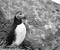 A puffin on Faraid Head - geograph.org.uk - 733047.jpg 640 × 531; 70 KB
-
 Aer Lingus Commuter Short 360 Watt-1.jpg 1,000 × 673; 399 KB
-
 Bilbster railway station 2126368.jpg 1,024 × 656; 511 KB
-
 Boat of Garten station geograph-3267592-by-Ben-Brooksbank.jpg 2,207 × 1,455; 1,021 KB
-
 Bower station site geograph-3268980-by-Ben-Brooksbank.jpg 2,394 × 1,457; 2.49 MB
-
 Bridge of Allan geograph-3479900-by-Ben-Brooksbank.jpg 2,392 × 1,616; 2.91 MB
-
 Brora station exterior geograph-3270375-by-Ben-Brooksbank.jpg 2,394 × 1,445; 4.13 MB
-
 Brora station, 1986 geograph-3270253-by-Ben-Brooksbank.jpg 2,395 × 1,450; 4.69 MB
-
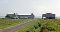 Caithness wilderness - Bilbster Mains Farm - geograph.org.uk - 2125711.jpg 1,024 × 553; 145 KB
-
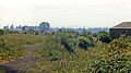
 Caithness wilderness from Bower - geograph.org.uk - 2125653.jpg 1,024 × 613; 248 KB
-
 Caithness wilderness near Bilbster - geograph.org.uk - 2125691.jpg 1,024 × 632; 326 KB
-
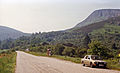
 Caithness wilderness on A9 near Loch Rangag - geograph.org.uk - 2125628.jpg 1,024 × 824; 472 KB
-
 Cambusavie Platform site geograph-3098928-by-Ben-Brooksbank.jpg 2,394 × 1,449; 2.57 MB
-
 Canonbie former station geograph-3099710-by-Ben-Brooksbank.jpg 2,252 × 1,375; 2.84 MB
-
 Canonbie station remains geograph-3099712-by-Ben-Brooksbank.jpg 1,971 × 1,449; 4.18 MB
-
 Cardrona geograph-3479176-by-Ben-Brooksbank.jpg 2,392 × 1,502; 2.67 MB
-
 Carnwath geograph-3479815-by-Ben-Brooksbank.jpg 2,338 × 1,360; 2.28 MB
-
 Carnwath station site geograph-3101454-by-Ben-Brooksbank.jpg 2,296 × 1,450; 3.15 MB
-
 Carr Bridge station down geograph-3101482-by-Ben-Brooksbank.jpg 2,395 × 1,421; 3.17 MB
-
 Carr Bridge station up geograph-3101469-by-Ben-Brooksbank.jpg 2,243 × 1,366; 2.52 MB
-
 Causewayhead station site geograph-3103470-by-Ben-Brooksbank.jpg 2,108 × 1,447; 2.74 MB
-
 Coilintuie geograph-3482094-by-Ben-Brooksbank.jpg 2,396 × 1,542; 2.94 MB
-
 Conon station remains, 1986 - geograph.org.uk - 3316950.jpg 2,395 × 1,460; 2.57 MB
-
 Crieff station site geograph-3332700-by-Ben-Brooksbank.jpg 2,342 × 1,307; 2.16 MB
-
 Culloden Moor station (remains) and Viaduct geograph-3092339-by-Ben-Brooksbank.jpg 2,352 × 1,381; 2.5 MB
-
 Culrain station geograph-3358078-by-Ben-Brooksbank.jpg 2,311 × 1,575; 4.01 MB
-
 Edston, Peebles geograph-3479289-by-Ben-Brooksbank.jpg 2,392 × 1,592; 3.72 MB
-
 Langholm geograph-3477546-by-Ben-Brooksbank.jpg 2,392 × 1,584; 3.92 MB
-
 Langholm, High Stree geograph-3477515-by-Ben-Brooksbank.jpg 2,332 × 1,378; 2.95 MB
-
 Loch Ossian and Ossian Youth Hostel - geograph.org.uk - 44599.jpg 640 × 502; 70 KB
-
 Mountbengerhope geograph-3479236-by-Ben-Brooksbank.jpg 2,333 × 1,413; 2.41 MB
-
 Newtonmore toposcope geograph-3481571-by-Ben-Brooksbank.jpg 2,343 × 1,418; 3.7 MB
-
 The Kyle of Durness - geograph.org.uk - 732975.jpg 640 × 422; 67 KB


_and_Viaduct_geograph-3092339-by-Ben-Brooksbank.jpg)


