Category:Interstate 80 in California
Jump to navigation
Jump to search
States of the United States: California · Illinois · Indiana · Iowa · Nebraska · Nevada · New Jersey · Ohio · Pennsylvania · Utah · Wyoming
section of Interstate Highway in California, United States  .svg)  | |||||
| Upload media | |||||
| Instance of | |||||
|---|---|---|---|---|---|
| Part of | |||||
| Location | |||||
| Transport network | |||||
| Owned by | |||||
| Maintained by | |||||
| Inception |
| ||||
| Length |
| ||||
| Terminus | |||||
| Partially coincident with |
| ||||
 | |||||
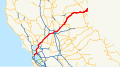
English: Media related to Interstate 80 in California, a 205.07-mile (330.03 km) section of Interstate Highway in California, United States.
Subcategories
This category has the following 20 subcategories, out of 20 total.
1
2
3
- Interstate 380 (California) (12 F)
4
- Interstate 480 (California) (9 F)
5
6
7
8
9
B
- Berkeley I-80 bridge (6 F)
C
- Central Freeway (5 F)
D
- Donner Summit (8 F)
I
L
- Long Ravine trestle (6 F)
M
- MacArthur Maze (9 F)
R
W
- Watt/I-80 (Sacramento RT) (9 F)
Y
- Yolo Causeway (14 F)
Media in category "Interstate 80 in California"
The following 114 files are in this category, out of 114 total.
-
 I-80 (CA).svg 600 × 600; 21 KB
-

-

-

-
 4horsemen - Urban Blood 4.jpg 960 × 1,200; 107 KB
-
 Bat flight.jpg 1,182 × 665; 121 KB
-
 Bayshore Freeway.svg 1,152 × 640; 320 KB
-
 California Highway Patrol ending pursuit with PIT on I-80.jpg 5,184 × 3,456; 3.4 MB
-
 California Highway Patrol Side of I-80.jpg 590 × 453; 39 KB
-
 California Interstate 80.svg 1,152 × 640; 631 KB
-
 Carquinez Bridge Toll Plaza and approach signage on east I-80 looking north.tiff 5,040 × 4,044; 19.44 MB
-
 CRW 1148 RJ.jpg 2,048 × 3,072; 1.11 MB
-
 Davis-i80-1.640.jpg 640 × 363; 44 KB
-
 Dixon-California-Milk-Farm-Sign.png 1,080 × 1,080; 2.11 MB
-
 Donner Lake, California (23256593360).jpg 2,403 × 1,635; 4.4 MB
-

-
 Eastbound Interstate 80, San Francisco.jpg 2,048 × 1,536; 691 KB
-
 Embarcadero Freeway map.png 936 × 1,202; 571 KB
-
 Entering West Sacramento, California, Interstate 80 (26101132156).jpg 3,300 × 1,948; 4.18 MB
-
 Entering Yolo County, California, Interstate 80 (25522281224).jpg 3,759 × 1,536; 4.36 MB
-
 I-680 Exit on I-80 East (33845530762).jpg 2,400 × 1,600; 1.57 MB
-
 I-80 - Vacaille, CA -2-.JPG 2,448 × 1,595; 468 KB
-
 I-80 altitude profile data.png 672 × 992; 41 KB
-
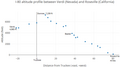 I-80 altitude profile.png 660 × 368; 17 KB
-
 I-80 Chadbourne.jpg 640 × 480; 39 KB
-
 I-80 Eastshore Fwy.jpg 1,600 × 1,152; 304 KB
-
 I-80 in Sierras 2.jpg 2,048 × 3,072; 1.12 MB
-
 I-80 West San Francisco (26059998995) Interstate Road Sign.jpg 2,257 × 1,313; 2.52 MB
-
 Int5sRoad-Exit522-Int80ew (32433851954).jpg 2,400 × 1,600; 1.56 MB
-
 Int80e-Int5nsCA99nsOverheadsBC (32893930990).jpg 2,400 × 1,600; 2.02 MB
-
 Int80eReno-Int5nCA99ReddingButtonCopySigns (32433852414).jpg 2,400 × 1,600; 1.56 MB
-
 Int80eRoad-PlacerCounty-Roseville (33121295732).jpg 2,400 × 1,600; 2.01 MB
-
 Int80eRoad-SignClearview (32433853774).jpg 2,400 × 1,600; 2.04 MB
-
 Int80eRoadCA-Int580ExitSign (33845525942).jpg 2,400 × 1,600; 1.55 MB
-
 Int80eRoadCA-Int780Exit-HalfMile (33845528122).jpg 2,400 × 1,600; 1.76 MB
-
 Int80wRoad-SMF-Longview-Auburn (32433852824).jpg 2,400 × 1,600; 2.02 MB
-
 Int80wRoadCA-Int880-Int580ButtonCopy (33845532562).jpg 2,400 × 1,600; 1.44 MB
-
 Interstate 80 10 2012-12-20.jpg 2,448 × 3,264; 2.29 MB
-
 Interstate 80 10 2012-12-21.jpg 3,264 × 2,448; 1.76 MB
-
 Interstate 80 11 2012-12-20.jpg 2,448 × 3,264; 1.5 MB
-
 Interstate 80 11 2012-12-21.jpg 3,264 × 2,448; 1.73 MB
-
 Interstate 80 12 2012-12-20.jpg 2,448 × 3,264; 2.36 MB
-
 Interstate 80 12 2012-12-21.jpg 3,264 × 2,448; 1.94 MB
-
 Interstate 80 13 2012-12-20.jpg 2,448 × 3,264; 2.39 MB
-
 Interstate 80 13 2012-12-21.jpg 3,264 × 2,448; 2 MB
-
 Interstate 80 14 2012-12-20.jpg 2,448 × 3,264; 2.46 MB
-
 Interstate 80 14 2012-12-21.jpg 2,448 × 3,264; 2.46 MB
-
 Interstate 80 15 2012-12-20.jpg 2,448 × 3,264; 2.46 MB
-
 Interstate 80 15 2012-12-21.jpg 3,264 × 2,448; 3.03 MB
-
 Interstate 80 16 2012-12-20.jpg 2,448 × 3,264; 2.53 MB
-
 Interstate 80 16 2012-12-21.jpg 3,264 × 2,448; 2.79 MB
-
 Interstate 80 17 2012-12-20.jpg 3,264 × 2,448; 2.51 MB
-
 Interstate 80 17 2012-12-21.jpg 3,264 × 2,448; 2.3 MB
-
 Interstate 80 18 2012-12-20.jpg 3,264 × 2,448; 2.46 MB
-
 Interstate 80 18 2012-12-21.jpg 3,264 × 2,448; 2.33 MB
-
 Interstate 80 19 2012-12-20.jpg 3,264 × 2,448; 2.17 MB
-
 Interstate 80 19 2012-12-21.jpg 3,264 × 2,448; 1.68 MB
-
 Interstate 80 20 2012-12-20.jpg 3,264 × 2,448; 2.44 MB
-
 Interstate 80 20 2012-12-21.jpg 3,264 × 2,448; 1.66 MB
-
 Interstate 80 21 2012-12-20.jpg 3,264 × 2,448; 2.48 MB
-
 Interstate 80 21 2012-12-21.jpg 3,264 × 2,448; 1.68 MB
-
 Interstate 80 22 2012-12-20.jpg 3,264 × 2,448; 2.32 MB
-
 Interstate 80 22 2012-12-21.jpg 3,264 × 2,448; 2.26 MB
-
 Interstate 80 23 2012-12-20.jpg 3,264 × 2,448; 2.36 MB
-
 Interstate 80 23 2012-12-21.jpg 3,264 × 2,448; 2.35 MB
-
 Interstate 80 24 2012-12-20.jpg 3,264 × 2,448; 2.47 MB
-
 Interstate 80 24 2012-12-21.jpg 3,264 × 2,448; 2.36 MB
-
 Interstate 80 25 2012-12-20.jpg 3,264 × 2,448; 1.83 MB
-
 Interstate 80 25 2012-12-21.jpg 2,448 × 3,264; 3.36 MB
-
 Interstate 80 26 2012-12-20.jpg 3,264 × 2,448; 1.89 MB
-
 Interstate 80 26 2012-12-21.jpg 3,264 × 2,448; 3.38 MB
-
 Interstate 80 27 2012-12-20.jpg 3,264 × 2,448; 1.9 MB
-
 Interstate 80 27 2012-12-21.jpg 3,264 × 2,448; 3 MB
-
 Interstate 80 28 2012-12-21.jpg 2,448 × 3,264; 2.41 MB
-
 Interstate 80 29 2012-12-21.jpg 2,448 × 3,264; 3.64 MB
-
 Interstate 80 30 2012-12-21.jpg 2,448 × 3,264; 2.11 MB
-
 Interstate 80 31 2012-12-21.jpg 2,448 × 3,264; 2.34 MB
-
 Interstate 80 32 2012-12-21.jpg 10,800 × 2,398; 9.84 MB
-
 Interstate 80 4 2012-12-20.jpg 3,264 × 2,448; 2.29 MB
-
 Interstate 80 5 2012-12-20.jpg 3,264 × 2,448; 2.16 MB
-
 Interstate 80 5 2012-12-21.jpg 2,448 × 3,264; 1.61 MB
-
 Interstate 80 6 2012-12-20.jpg 3,264 × 2,448; 2.2 MB
-
 Interstate 80 6 2012-12-21.jpg 3,264 × 2,448; 1.6 MB
-
 Interstate 80 7 2012-12-20.jpg 3,264 × 2,448; 2.14 MB
-
 Interstate 80 7 2012-12-21.jpg 3,264 × 2,448; 1.6 MB
-
 Interstate 80 8 2012-12-20.jpg 3,264 × 2,448; 2.09 MB
-
 Interstate 80 8 2012-12-21.jpg 3,264 × 2,448; 1.77 MB
-
 Interstate 80 9 2012-12-20.jpg 3,264 × 2,448; 2.24 MB
-
 Interstate 80 9 2012-12-21.jpg 3,264 × 2,448; 1.75 MB
-
 Interstate 80 E near Interstate 580 interchange.JPG 3,264 × 2,448; 1.54 MB
-
 Interstate 80, Fairfield, California (32936591825).jpg 3,904 × 2,307; 5.3 MB
-
 Junction of Interstate 80 and U.S. Highway 50, Sacramento, California (26061806921).jpg 4,000 × 1,682; 4.75 MB
-

-
 MacArthur Maze.jpg 3,765 × 1,878; 6.34 MB
-
 New BART car being trucked on I-80, June 2019.jpg 1,465 × 733; 107 KB
-
 Ohlonemural80.jpg 640 × 480; 62 KB
-
 On Interstate 80 east to Sacramento 1.JPG 4,000 × 2,248; 609 KB
-
 On Interstate 80 east to Sacramento 2.JPG 4,000 × 2,248; 584 KB
-
 On Interstate 80 east to Sacramento 3.JPG 4,000 × 2,248; 711 KB
-
 On Interstate 80 east to Sacramento 4.JPG 4,000 × 2,248; 770 KB
-
 Pinole Creek Fish Passage Project (32238827220).jpg 5,760 × 3,840; 12.34 MB
-
 Reno I-80 Nevada 8286704046 o.jpg 612 × 612; 103 KB
-
 Rest area, Donner Summit, California, USA (Interstate 80 Westbound).jpg 1,200 × 803; 510 KB
-
 Roseville Subdivision bridge in Auburn, March 2016.jpg 3,033 × 1,415; 3.34 MB
-
 San Francisco, California 1955 Yellow Book.jpg 800 × 931; 134 KB
-
 Sunset At The Summit Of The Sierras - panoramio.jpg 2,592 × 1,936; 916 KB
-
 Traffic Jam on Interstate 80, West Sacramento, California (25854218610).jpg 3,089 × 1,964; 6.26 MB
-
 Traffic Jam on Interstate 80, West Sacramento, California (26034553722).jpg 4,000 × 3,000; 2.24 MB
-
 Traffic Jam on Interstate 80, West Sacramento, California (26101135996).jpg 4,000 × 1,687; 6.06 MB
-
 View from Interstate 80 1 2018-12-23.jpg 4,032 × 3,024; 4.6 MB
-
 View from Interstate 80 2 2018-12-23.jpg 4,032 × 3,024; 4.53 MB
-
 Views from California Zephyr - 2021-11-15 - Sarah Stierch 07.jpg 4,032 × 3,024; 4.2 MB
-
 Welcometofairfield.jpg 1,234 × 922; 249 KB
-
 Western Area Power Administation's 500 kV power line crossing I-80, Vacavlle, CA.JPG 2,048 × 1,536; 661 KB
.jpg)


.jpg)


.jpg)
.jpg)


_Interstate_Road_Sign.jpg)
.jpg)
.jpg)
.jpg)
.jpg)
.jpg)
.jpg)
.jpg)
.jpg)


.jpg)
.jpg)


.jpg)

.jpg)


.jpg)
.jpg)
.jpg)


.jpg)
.jpg)
.jpg)
.jpg)