Category:Indonesia maps by U.S. Army Map Service
Jump to navigation
Jump to search
Media in category "Indonesia maps by U.S. Army Map Service"
The following 16 files are in this category, out of 16 total.
-
 Aru North txu-oclc-6558822-sb53-2.jpg 4,326 × 4,797; 3.34 MB
-
 Aru South txu-oclc-6558822-sb53-5.jpg 4,288 × 4,790; 3.24 MB
-
 Aru txu-oclc-6558822-sb53-2+5.jpg 2,277 × 3,447; 809 KB
-
 Aru txu-oclc-6558822-sb53-2+5.png 2,277 × 3,447; 22.5 MB
-
 Bojonegoro map from us army map service.png 560 × 533; 678 KB
-
 Karte Pulau Nias.jpg 4,619 × 4,458; 4.96 MB
-
 Karte Pulau Sumba.jpg 6,405 × 3,615; 5.05 MB
-
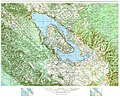 Map of Lake Toba.jpg 4,037 × 3,282; 4.76 MB
-
 Nusakambangan map from AMS in UTexas Library.png 1,154 × 458; 1.42 MB
-
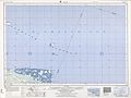 Schouten Islands (Papua New Guinea) txu-oclc-6552576-sa55-13.jpg 5,000 × 3,769; 2.67 MB
-
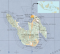
 Tarakan region 1961 map.jpg 5,000 × 3,825; 3.18 MB
-
 USAMS New Guinea Map Series T401 SA 53-5 Geelvink Bay.jpg 4,308 × 4,757; 3.8 MB
-
 Weh Island.png 800 × 718; 1.17 MB
-
 Yos Sudarso NE txu-oclc-6552576-sb54-13.jpg 5,000 × 3,395; 3.01 MB
-
 Yos Sudarso SE txu-oclc-6552576-sc54-1.jpg 5,000 × 3,751; 3.37 MB
-
 Yos Sudarso SW txu-oclc-6552576-sc53-4.jpg 5,000 × 3,754; 2.55 MB


_txu-oclc-6552576-sa55-13.jpg)


