Category:Income distribution maps of the United States
Jump to navigation
Jump to search
Countries of the Americas: United States of America
Subcategories
This category has the following 2 subcategories, out of 2 total.
Media in category "Income distribution maps of the United States"
The following 34 files are in this category, out of 34 total.
-
 Albuquerque Income.png 996 × 639; 228 KB
-
 American FactFinder - Results - Google Chrome 2016-03-15 17.52.05.png 882 × 701; 255 KB
-
 Block Group Level Map of Median Household Income in the Contiguous United States.png 10,000 × 6,456; 13.14 MB
-
 Block Group Level Map of Median Household Income in the Contiguous United States.svg 13,333 × 8,609; 135.94 MB
-
 Boston income donut.png 626 × 693; 200 KB
-
 Figure02-high wage occupations.gif 560 × 410; 32 KB
-
 Geo Map of Income by Location in Florida.png 759 × 882; 174 KB
-
 Geo Map of Income by Location in Pennsylvania.png 1,122 × 882; 494 KB
-
 Geo Map of Income by Location in Texas (2014).png 802 × 882; 246 KB
-
 Gini Index US Counties 2010.jpg 1,835 × 1,355; 818 KB
-
 Gini United States by state 2019.svg 512 × 324; 204 KB
-
 Income in Oregon by County.png 1,052 × 708; 139 KB
-
 List of lowest-income counties in the United States.png 1,275 × 1,176; 580 KB
-
 Map of Income by Location in New Jersey.png 750 × 882; 338 KB
-
 Median Household Income in USA, by county (2013-2017).jpg 2,000 × 1,512; 1.62 MB
-
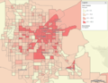
 Monterey County Populated Area Median Household Income 2013.png 1,126 × 1,069; 1.51 MB
-
 NetRevenue2004Cartogram.png 1,693 × 908; 181 KB
-
 NY per capita income by county 2010.png 655 × 492; 16 KB
-
 OregonFinal.png 1,100 × 850; 155 KB
-
 Percent living at less than 100 percent poverty in the US.svg 959 × 593; 95 KB
-
 Percent living at less than 200 percent poverty in the US.svg 959 × 593; 95 KB
-
 Percent living at less than 50 percent poverty in the US.svg 959 × 593; 95 KB
-
 Poverty in Maricopa County.png 785 × 641; 211 KB
-
 Poverty Las Vegas Valley.png 850 × 662; 246 KB
-
 Salinas-Poverty.png 502 × 610; 297 KB
-

-
 Share Affluent Households Monterey County.png 1,108 × 699; 261 KB
-
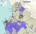
 Silicon Valley Income Map 20160315.png 954 × 700; 442 KB
-
 Towns income per capita in MA.jpg 788 × 466; 104 KB
-
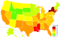
 United States Map of Median Household Income by State (2015).svg 850 × 499; 516 KB
-
 US counties by per capita income.png 1,513 × 983; 197 KB
-
 US Poverty Rates.svg 555 × 352; 1.27 MB
-
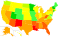
 US states by poverty rate.svg 959 × 593; 165 KB
-
 Virginia-Per Capita income.svg 792 × 344; 391 KB


.png)


.jpg)


.png)


.svg)


