Category:Images by Rudi Winter
Jump to navigation
Jump to search

Media in category "Images by Rudi Winter"
The following 200 files are in this category, out of 1,300 total.
(previous page) (next page)-
 A narrow path in Bute Park, Cardiff - geograph.org.uk - 221676.jpg 480 × 640; 147 KB
-
 A44 snaking away below Plynlimon - geograph.org.uk - 389478.jpg 478 × 640; 74 KB
-
 Abandoned lead mine at Cwmrheidol - geograph.org.uk - 153798.jpg 479 × 640; 73 KB
-
 Abandoned slate quarry above Llanberis - geograph.org.uk - 71029.jpg 640 × 480; 86 KB
-
 Aberystwyth at sunset - geograph.org.uk - 58913.jpg 640 × 480; 69 KB
-
 Aberystwyth castle - geograph.org.uk - 1746753.jpg 1,024 × 768; 303 KB
-
 Aberystwyth harbour - geograph.org.uk - 1409360.jpg 640 × 480; 92 KB
-
 Aberystwyth harbour dredging - geograph.org.uk - 720063.jpg 640 × 480; 80 KB
-
 Aberystwyth harbour dredging - geograph.org.uk - 720097.jpg 640 × 480; 63 KB
-
 Aberystwyth harbour dredging - geograph.org.uk - 720142.jpg 640 × 479; 61 KB
-
 Aberystwyth harbour dredging - geograph.org.uk - 720160.jpg 640 × 479; 66 KB
-
 Aberystwyth harbour dredging - geograph.org.uk - 720174.jpg 640 × 479; 78 KB
-
 Aberystwyth harbour jetty - geograph.org.uk - 1746838.jpg 768 × 1,024; 262 KB
-
 Aberystwyth harbour mouth at sunset - geograph.org.uk - 1751768.jpg 1,024 × 768; 121 KB
-
 Aberystwyth Promenade - geograph.org.uk - 658637.jpg 640 × 480; 58 KB
-
 Aberystwyth South Beach - geograph.org.uk - 1746725.jpg 1,024 × 768; 231 KB
-
 Aberystwyth South Beach - geograph.org.uk - 658595.jpg 640 × 480; 75 KB
-

-
 Afon Brennig - geograph.org.uk - 1214667.jpg 640 × 480; 123 KB
-
 Afon Cadair - geograph.org.uk - 464572.jpg 640 × 479; 122 KB
-
 Afon Castell - geograph.org.uk - 274006.jpg 640 × 480; 99 KB
-
 Afon Cwmnantcol - geograph.org.uk - 1276473.jpg 480 × 640; 165 KB
-
 Afon Diliw - geograph.org.uk - 1031480.jpg 640 × 640; 231 KB
-
 Afon Doethie - geograph.org.uk - 81326.jpg 480 × 640; 92 KB
-
 Afon Doethie - geograph.org.uk - 887313.jpg 640 × 479; 71 KB
-
 Afon Doethie - geograph.org.uk - 913292.jpg 479 × 640; 73 KB
-
 Afon Doethie rapids - geograph.org.uk - 913379.jpg 479 × 640; 94 KB
-
-
 Afon Glasffrwd - geograph.org.uk - 721091.jpg 479 × 640; 115 KB
-
 Afon Glasffrwd - geograph.org.uk - 721126.jpg 479 × 640; 80 KB
-
 Afon Hengwm - geograph.org.uk - 513920.jpg 640 × 479; 73 KB
-
 Afon Mwyro - geograph.org.uk - 402211.jpg 480 × 640; 60 KB
-
 Afon Sychlwch - geograph.org.uk - 170504.jpg 359 × 480; 68 KB
-

-
 Afon Ystwyth - geograph.org.uk - 1083144.jpg 640 × 480; 214 KB
-
 Afon Ystwyth at Tanybwlch - geograph.org.uk - 1748558.jpg 1,024 × 768; 198 KB
-

-
 Afon Ystwyth meander - geograph.org.uk - 1076348.jpg 640 × 480; 214 KB
-
 Afon Ystwyth, Grogwynion - geograph.org.uk - 1076329.jpg 480 × 640; 206 KB
-
 Allt Ddu - geograph.org.uk - 1214154.jpg 640 × 480; 113 KB
-
 Along the forest boundary - geograph.org.uk - 1234674.jpg 640 × 480; 134 KB
-
 Ancient cairn on Garn Gron's main summit - geograph.org.uk - 1214497.jpg 640 × 640; 177 KB
-
 Ancient cairn on Garn Gron's main summit - geograph.org.uk - 1214501.jpg 640 × 480; 146 KB
-
 Ancient site or not^ - geograph.org.uk - 1214392.jpg 640 × 480; 177 KB
-
 Animal burrow - geograph.org.uk - 182147.jpg 480 × 640; 106 KB
-
 Approaching Bwlch y Rhiwgyr - geograph.org.uk - 1752939.jpg 1,024 × 768; 319 KB
-
 Ardudwy from the Diffwys ridge - geograph.org.uk - 1755073.jpg 1,024 × 768; 285 KB
-
 Arum plant near Patrishow - geograph.org.uk - 222090.jpg 480 × 640; 77 KB
-

-
 At the foot of y Braich - geograph.org.uk - 1752282.jpg 1,024 × 768; 224 KB
-
 Banc Blaenegnant - geograph.org.uk - 1706417.jpg 1,024 × 768; 294 KB
-
 Banc Hendre'r Dail - geograph.org.uk - 887237.jpg 640 × 479; 51 KB
-
 Banc yr Wyn - geograph.org.uk - 1133009.jpg 640 × 480; 178 KB
-
 Banc-y-Frân - geograph.org.uk - 1752273.jpg 1,024 × 768; 222 KB
-
 Barmouth Bridge - geograph.org.uk - 1431154.jpg 640 × 480; 102 KB
-
 Barn, National History Museum of Wales.jpg 640 × 480; 133 KB
-
 Bedding and cleavage - geograph.org.uk - 1234615.jpg 640 × 640; 300 KB
-
 Below the summit of Rhinog Fawr - geograph.org.uk - 1282401.jpg 640 × 480; 126 KB
-
 Bird's eye view of Llyn Gwynant - geograph.org.uk - 663860.jpg 640 × 480; 49 KB
-
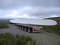 Blade on a lorry - geograph.org.uk - 519748.jpg 640 × 479; 44 KB
-
 Blaen Camddwr - geograph.org.uk - 1805092.jpg 1,024 × 768; 376 KB
-
 Blaen Camddwr from Esgair Ambor - geograph.org.uk - 1805151.jpg 1,024 × 768; 358 KB
-
 Blaen Cwm Ruddwen - geograph.org.uk - 887319.jpg 479 × 640; 70 KB
-
 Blaen y Cwm - geograph.org.uk - 1031433.jpg 640 × 480; 114 KB
-
 Blaenau tunnel vent - geograph.org.uk - 216111.jpg 640 × 479; 87 KB
-
 Blaendoethie - geograph.org.uk - 81287.jpg 640 × 480; 101 KB
-
 Blaentawe - geograph.org.uk - 171076.jpg 480 × 359; 29 KB
-
 Blaenycwm - geograph.org.uk - 1032443.jpg 640 × 480; 146 KB
-
 Blorenge - view west - geograph.org.uk - 221863.jpg 640 × 326; 50 KB
-
 Bluebell near Pennant - geograph.org.uk - 809605.jpg 480 × 640; 41 KB
-
 Boardwalk, Cors Caron Nature Reserve - geograph.org.uk - 1650093.jpg 768 × 1,024; 410 KB
-
 Bog at the head of the Nant Hafod-frith - geograph.org.uk - 1704212.jpg 1,024 × 768; 354 KB
-
 Bog at the head of the Nant Hafod-frith - geograph.org.uk - 1706329.jpg 1,024 × 768; 385 KB
-
 Bog beside the Afon Elan - geograph.org.uk - 1032721.jpg 640 × 480; 177 KB
-
 Bog between Garn Gron and y Bryn - geograph.org.uk - 1214592.jpg 640 × 480; 130 KB
-
 Bog by the side of the Groes Fawr - geograph.org.uk - 1803761.jpg 1,024 × 768; 282 KB
-
 Bog moss in autumn colours - geograph.org.uk - 1031544.jpg 640 × 640; 407 KB
-
 Bog pond on Ffridd Bwlch-lluan - geograph.org.uk - 1234925.jpg 640 × 480; 148 KB
-
 Bog pond, Cors Caron Nature Reserve - geograph.org.uk - 1650027.jpg 1,024 × 768; 211 KB
-
 Bog stream on Disgwilfa - geograph.org.uk - 1704199.jpg 1,024 × 768; 319 KB
-
 Bog west of Garn Gron - geograph.org.uk - 1214551.jpg 640 × 480; 129 KB
-
 Boggy depression by the Afon Groes Fawr - geograph.org.uk - 1803922.jpg 1,024 × 768; 445 KB
-
 Boggy depression east of Disgwilfa - geograph.org.uk - 1706370.jpg 640 × 480; 142 KB
-
 Boggy patch on Ffridd Bwlch-lluan - geograph.org.uk - 1234891.jpg 640 × 480; 141 KB
-
 Boggy patch on Mynydd Llwyn-Gwern - geograph.org.uk - 1234683.jpg 640 × 480; 141 KB
-
 Boggy pond near Craig Ysbio - geograph.org.uk - 389548.jpg 640 × 479; 54 KB
-
 Boggy pond on Ffridd Rhydybiswail - geograph.org.uk - 1234933.jpg 640 × 480; 112 KB
-
 Boggy pond on Plynlimon's eastern col - geograph.org.uk - 59255.jpg 640 × 480; 91 KB
-
 Boggy pond on the Diffwys ridge - geograph.org.uk - 1755081.jpg 1,024 × 768; 271 KB
-
 Boggy pool east of Esgair Ambor - geograph.org.uk - 1805235.jpg 1,024 × 768; 389 KB
-
 Boggy ridge between y Bryn and Garn Gron - geograph.org.uk - 1214617.jpg 640 × 480; 129 KB
-
 Boggy slope at Nantcol - geograph.org.uk - 1276747.jpg 640 × 480; 152 KB
-
 Boggy valley below Bwlch Stwlan - geograph.org.uk - 60559.jpg 640 × 480; 82 KB
-
-

-
 Boston Lodge works, Ffestiniog Railway - geograph.org.uk - 926437.jpg 640 × 480; 106 KB
-
 Boulder near Nantcol - geograph.org.uk - 1276485.jpg 640 × 480; 168 KB
-
 Boulders beside Llyn Du - geograph.org.uk - 1282642.jpg 480 × 640; 150 KB
-
 Boundary wall on Diffwys ridge - geograph.org.uk - 1754932.jpg 1,024 × 768; 240 KB
-

-
 Bracken-covered slope in Cwm Doethie - geograph.org.uk - 913211.jpg 479 × 640; 111 KB
-
 Braiding patterns of the Afon Ystwyth - geograph.org.uk - 1082013.jpg 640 × 480; 166 KB
-
 Breached mine pond at Esgair Hir - geograph.org.uk - 1132875.jpg 640 × 480; 177 KB
-
 Brecon Beacons National Park sign - geograph.org.uk - 221859.jpg 480 × 640; 130 KB
-
 Bridge Street, Cambridge - geograph.org.uk - 964687.jpg 640 × 479; 127 KB
-

-
 Bridle shortcut - geograph.org.uk - 811185.jpg 640 × 479; 98 KB
-
 Bridleway alongside the Groes Fawr - geograph.org.uk - 1803441.jpg 1,024 × 768; 263 KB
-
 Bridleway fording the Groes Fechan - geograph.org.uk - 1803369.jpg 1,024 × 768; 311 KB
-
 Bridleway on the side of Pen y Gurnos - geograph.org.uk - 910696.jpg 479 × 640; 56 KB
-
 Bronze age cairn field - geograph.org.uk - 1214405.jpg 640 × 480; 85 KB
-
 Bronze age cairn on Bryn Cosyn - geograph.org.uk - 1804973.jpg 1,024 × 768; 283 KB
-
 Bryn Cader Faner stone circle - geograph.org.uk - 185579.jpg 640 × 480; 49 KB
-
 Bryn Cader Faner stone circle - geograph.org.uk - 185580.jpg 640 × 479; 76 KB
-
 Bryn Castell - geograph.org.uk - 1752290.jpg 1,024 × 768; 222 KB
-
 Bryn Coch and the Dyfi estuary - geograph.org.uk - 1234648.jpg 640 × 480; 109 KB
-
 Bryn Eithinog and Lan Fawr - geograph.org.uk - 1706349.jpg 1,024 × 768; 343 KB
-
 Bryn Llyn Teifi - geograph.org.uk - 1706446.jpg 1,024 × 768; 217 KB
-
 Bryn Moel earthwork - geograph.org.uk - 1189887.jpg 640 × 480; 161 KB
-
 Bugeilyn - geograph.org.uk - 182776.jpg 640 × 479; 78 KB
-
 Burnt grass patches - geograph.org.uk - 705508.jpg 640 × 479; 64 KB
-

-
 Bwlch Blaen Twrch - geograph.org.uk - 171055.jpg 480 × 359; 29 KB
-
 Bwlch Drws Ardudwy - geograph.org.uk - 1273971.jpg 640 × 640; 204 KB
-
 Bwlch Drws Ardudwy - geograph.org.uk - 1273979.jpg 640 × 480; 154 KB
-
 Bwlch Drws Ardudwy - geograph.org.uk - 1276463.jpg 480 × 640; 159 KB
-
 Bwlch Fflur - geograph.org.uk - 1214436.jpg 640 × 480; 134 KB
-
 Bwlch Giedd and Llyn y Fan Fawr - geograph.org.uk - 171066.jpg 480 × 359; 30 KB
-
 Bwlch Gorddi - geograph.org.uk - 1189894.jpg 640 × 480; 126 KB
-
 Bwlch Llanfechan - geograph.org.uk - 1234807.jpg 640 × 480; 126 KB
-
 Bwlch Lluan - geograph.org.uk - 1234860.jpg 640 × 480; 109 KB
-
 Bwlch Moelfre - geograph.org.uk - 809917.jpg 640 × 479; 48 KB
-
 Bwlch Moelfre and Cwm Ceulan - geograph.org.uk - 811141.jpg 640 × 479; 56 KB
-
 Bwlch y Rhiwgyr - geograph.org.uk - 1752999.jpg 1,024 × 768; 288 KB
-
 Bwlch y Rhiwgyr - geograph.org.uk - 1753039.jpg 1,024 × 768; 311 KB
-
 Bwlch y Rhiwgyr - geograph.org.uk - 1753084.jpg 768 × 1,024; 268 KB
-
 Bwlchyddwyallt farm - geograph.org.uk - 1214322.jpg 640 × 480; 121 KB
-
 By the side of the Afon Twymyn - geograph.org.uk - 809512.jpg 479 × 640; 79 KB
-
 Byrlymau Elan - geograph.org.uk - 1032689.jpg 480 × 640; 173 KB
-
 Cae Goronwy - geograph.org.uk - 1762551.jpg 1,024 × 768; 373 KB
-
 Caeadda farm - geograph.org.uk - 1234995.jpg 480 × 640; 130 KB
-
 Caemadog quarry - geograph.org.uk - 652235.jpg 640 × 479; 122 KB
-
 Caernarfon and northern Snowdonia - geograph.org.uk - 58922.jpg 640 × 480; 76 KB
-
 Cairn at the head of Cwm Egnant - geograph.org.uk - 1706421.jpg 1,024 × 768; 188 KB
-

-
 Cardiff Bay marina - geograph.org.uk - 221672.jpg 640 × 480; 58 KB
-
 Carn Fach Bugeilyn - geograph.org.uk - 182629.jpg 640 × 479; 99 KB
-
 Carn Hyddgen ridge - geograph.org.uk - 513978.jpg 640 × 479; 74 KB
-
 Carn Menyn - geograph.org.uk - 1917437.jpg 1,024 × 768; 315 KB
-
 Carn Pen Rhiw y Llwydog - geograph.org.uk - 81299.jpg 640 × 480; 91 KB
-
 Carreg Ti-Pw - geograph.org.uk - 704115.jpg 480 × 640; 52 KB
-
 Castell Rhyfel - geograph.org.uk - 1803607.jpg 768 × 1,024; 373 KB
-
 Castell Rhyfel - geograph.org.uk - 519547.jpg 640 × 479; 62 KB
-
 Castell Rhyfel from below - geograph.org.uk - 1803528.jpg 1,024 × 768; 318 KB
-
 CAT Valley - geograph.org.uk - 1234663.jpg 480 × 640; 139 KB
-
 Cautley Spout - geograph.org.uk - 243597.jpg 480 × 640; 75 KB
-
 Cautley Spout - geograph.org.uk - 243601.jpg 480 × 640; 87 KB
-
 Cefn Croes power station on Bryn Diliw - geograph.org.uk - 1031443.jpg 640 × 479; 116 KB
-
 Cefn Neint - geograph.org.uk - 1031503.jpg 640 × 480; 121 KB
-
 Cefn Neint, overlooking Gors Lwyd - geograph.org.uk - 1031531.jpg 640 × 480; 139 KB
-
 Ceredigion Coast Path - geograph.org.uk - 1764442.jpg 1,024 × 768; 175 KB
-
 Ceredigion coast path - geograph.org.uk - 704254.jpg 479 × 640; 49 KB
-

-
 Ceulan track - geograph.org.uk - 809639.jpg 479 × 640; 89 KB
-
 Ceunant Ty'n y Ddol - geograph.org.uk - 203090.jpg 640 × 479; 68 KB
-
 Chapel within Strata Florida abbey - geograph.org.uk - 652911.jpg 640 × 479; 69 KB
-
 Circular lake on Mynydd Glandulas - geograph.org.uk - 1234649.jpg 640 × 480; 130 KB
-

-
 Clear puddle in coniferous forest - geograph.org.uk - 739394.jpg 640 × 480; 284 KB
-
 Clearing by the side of Llyn Brianne - geograph.org.uk - 887108.jpg 640 × 480; 201 KB
-
 Cliff edge above Pennant Isaf - geograph.org.uk - 809318.jpg 640 × 479; 48 KB
-
 Cliff face north of Carreg Ti-Pw - geograph.org.uk - 704168.jpg 479 × 640; 57 KB
-
 Cliff near Moel Ddinas - geograph.org.uk - 185603.jpg 640 × 479; 94 KB
-
 Cliffs above Llyn Du - geograph.org.uk - 1282608.jpg 640 × 480; 205 KB
-
 Cliffs south of Aberystwyth at sunset - geograph.org.uk - 58916.jpg 640 × 480; 75 KB
-
 Clifftop field boundary - geograph.org.uk - 704209.jpg 479 × 640; 75 KB
-
 Clifftop gorse - geograph.org.uk - 705363.jpg 640 × 479; 53 KB
-
 Clifftop path - geograph.org.uk - 704280.jpg 479 × 640; 45 KB
-
 Clipyn Du - geograph.org.uk - 514561.jpg 479 × 640; 51 KB
-
 Clogwyn yr Adar - geograph.org.uk - 203067.jpg 478 × 640; 104 KB
-
 Clogwyn yr Eryr - geograph.org.uk - 61028.jpg 640 × 480; 126 KB
-

-
 Cloud drifting in over the Mawddach estuary - geograph.org.uk - 1754986.jpg 1,024 × 768; 269 KB
-
 Coastal headland on the Cardigan Bay - geograph.org.uk - 705408.jpg 640 × 479; 43 KB
-

-
 Coed Cilmeddu - geograph.org.uk - 1082164.jpg 640 × 480; 256 KB
-
 Coed Maenarthur - geograph.org.uk - 1083026.jpg 640 × 480; 215 KB
-
 Coed y Pennant - geograph.org.uk - 464613.jpg 640 × 479; 92 KB
-
 Community turbine - geograph.org.uk - 1234697.jpg 640 × 640; 125 KB
-
 Concrete boundary marker on Esgair Elan - geograph.org.uk - 1031645.jpg 640 × 480; 156 KB
-
 Confluence of Nant Gwinau and Tywi - geograph.org.uk - 740563.jpg 640 × 479; 69 KB
-
 Cors Caron - geograph.org.uk - 1214671.jpg 640 × 480; 163 KB
-
 Cors Caron Nature Reserve - geograph.org.uk - 1651584.jpg 768 × 1,024; 277 KB
-
 Cors y Ddalfa - geograph.org.uk - 1031620.jpg 640 × 480; 140 KB
-
 Crags on Crug Hywel - Table Mountain - geograph.org.uk - 222162.jpg 640 × 480; 78 KB
-
 Crags, heather and drystone walls - geograph.org.uk - 1282521.jpg 640 × 480; 156 KB
-
 Craig Ddu - geograph.org.uk - 928795.jpg 640 × 479; 60 KB
-
 Craig y Gath - geograph.org.uk - 811237.jpg 479 × 640; 80 KB
-
 Craig y Llyn - geograph.org.uk - 464735.jpg 640 × 479; 41 KB
-
 Craig y Maes - geograph.org.uk - 809295.jpg 640 × 479; 56 KB


