Category:Images by Roger Templeman
Jump to navigation
Jump to search

Media in category "Images by Roger Templeman"
The following 95 files are in this category, out of 95 total.
-
 Appleby Heritage Centre, Steam Locomotive - geograph.org.uk - 1933670.jpg 1,024 × 768; 138 KB
-
 Archway in city wall across Station Road - geograph.org.uk - 2364565.jpg 800 × 533; 108 KB
-
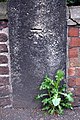
 Bench mark on culvert wall near Aston Tirrold - geograph.org.uk - 1736533.jpg 1,600 × 1,071; 578 KB
-
 Bench Mark on St Martin's Church - geograph.org.uk - 1746234.jpg 686 × 1,024; 251 KB
-

-
 Benchmark on archway pier of Micklegate Bar - geograph.org.uk - 2361466.jpg 683 × 1,024; 177 KB
-

-

-

-

-
 Benchmark on gatepost of ^2 York Place - geograph.org.uk - 1999813.jpg 844 × 1,024; 257 KB
-

-

-

-
 Benchmark on Rock Church, Priory Street - geograph.org.uk - 2361531.jpg 1,024 × 683; 241 KB
-

-
 Benchmark on St William of York Church - geograph.org.uk - 4121054.jpg 1,024 × 683; 238 KB
-
-
 Benchmark on The Anchor pub, York Road - geograph.org.uk - 2193498.jpg 600 × 800; 194 KB
-
 Benchmark on the bridge of York Bridge - geograph.org.uk - 2353233.jpg 1,024 × 683; 268 KB
-
-
 Benchmark on the Old School House - geograph.org.uk - 1746277.jpg 686 × 1,024; 159 KB
-

-
 Benchmark on the water tower, Park Lane - geograph.org.uk - 2713732.jpg 683 × 1,024; 138 KB
-

-
-
 Benchmark on tower buttress of St Denys Walmgate - geograph.org.uk - 2362053.jpg 1,024 × 683; 230 KB
-
 Benchmark on wall of Toft Green - geograph.org.uk - 2361391.jpg 800 × 533; 188 KB
-
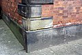
 Benchmark on wall of ^5 South Esplanade - geograph.org.uk - 2361938.jpg 1,024 × 683; 226 KB
-
 Benchmark on Waterstones, High Ousegate - geograph.org.uk - 2361818.jpg 1,024 × 837; 270 KB
-
 Benchmark on York House, Upper Piccadilly - geograph.org.uk - 5642564.jpg 666 × 1,024; 236 KB
-
 Benchmark on York Street building - geograph.org.uk - 2739911.jpg 1,024 × 683; 266 KB
-

-

-
 Benchmark on ^13 York Place - geograph.org.uk - 3581299.jpg 683 × 1,024; 245 KB
-
 Benchmark on ^18 York Road - geograph.org.uk - 4352835.jpg 1,024 × 683; 197 KB
-
 Benchmark on ^2 York Road - geograph.org.uk - 2405992.jpg 683 × 1,024; 244 KB
-
 Benchmark on ^36 York Road - geograph.org.uk - 4870456.jpg 683 × 1,024; 249 KB
-
 Benchmark on ^39 York Grove - geograph.org.uk - 3536105.jpg 1,024 × 683; 294 KB
-
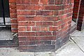
 Benchmark on ^45 Micklegate - geograph.org.uk - 2361571.jpg 1,024 × 683; 217 KB
-
 Benchmark on ^9 Tower Place - geograph.org.uk - 2362013.jpg 800 × 533; 160 KB
-
 Benchmark on ^98 Banbury Road, Bicester - geograph.org.uk - 1804022.jpg 600 × 800; 154 KB
-

-
 Buildings on the SW side of Leeman Road - geograph.org.uk - 2364635.jpg 1,024 × 683; 139 KB
-
 City Road Baptist Church from Upper York Street - geograph.org.uk - 5675407.jpg 683 × 1,024; 144 KB
-

-
 Damaged benchmark on All Saints Church - geograph.org.uk - 2360941.jpg 800 × 533; 158 KB
-
-
 Didcot Station, Car train - geograph.org.uk - 1827001.jpg 1,024 × 686; 191 KB
-
 Didcot Station, Cement train - geograph.org.uk - 1883399.jpg 1,024 × 686; 177 KB
-
 Didcot Station, Stabled locomotive - geograph.org.uk - 1826996.jpg 1,024 × 686; 184 KB
-

-
-
 Edward VII pillar box - geograph.org.uk - 2983972.jpg 683 × 1,024; 302 KB
-
 Flush Bracket benchmark on St John's Church - geograph.org.uk - 1746294.jpg 686 × 1,024; 295 KB
-

-
 Former Public Baths, Barnsley.jpg 1,024 × 683; 156 KB
-
 Former Wantage UDC (Council) Offices, Portway, Wantage, Oxon.jpg 931 × 622; 176 KB
-

-
 Inside the Memorial Stadium - geograph.org.uk - 2018261.jpg 1,024 × 768; 179 KB
-
 Junction of Britannia Street and Back York Place - geograph.org.uk - 3581250.jpg 683 × 1,024; 189 KB
-
 Junction of Cross York Street and Kirkgate - geograph.org.uk - 3775453.jpg 1,024 × 683; 206 KB
-
 Junction of Friar Street and Station Road - geograph.org.uk - 2381746.jpg 1,024 × 683; 172 KB
-
 Junction of York Place and Britannia Street - geograph.org.uk - 3581348.jpg 683 × 1,024; 179 KB
-
 Junction of York Road and Guildford Road - geograph.org.uk - 4352743.jpg 683 × 1,024; 162 KB
-
 Junction of York Road and Wych Hill Lane - geograph.org.uk - 4352584.jpg 1,024 × 683; 179 KB
-
-

-
 Little Red Bus and a coal train at Garsdale - geograph.org.uk - 2124660.jpg 1,024 × 686; 220 KB
-
 Nos. 16 and 17 St Pauls Street (geograph 4872970).jpg 1,024 × 683; 210 KB
-
 Post box in brick pillar - geograph.org.uk - 258164.jpg 480 × 640; 117 KB
-

-
 Semi-detached houses on York Road - geograph.org.uk - 4352558.jpg 1,024 × 683; 180 KB
-

-
 St James's Church - geograph.org.uk - 5209889.jpg 1,024 × 660; 116 KB
-
 St Mary's Church, Great Brickhill - geograph.org.uk - 5306981.jpg 1,024 × 683; 184 KB
-
 St Michael Tilehurst, New Lane - geograph.org.uk - 2683186.jpg 683 × 1,024; 137 KB
-
 St William of York Church, Upper Redlands Road - geograph.org.uk - 4121084.jpg 1,024 × 683; 169 KB
-
 Stock Hill trig point - geograph.org.uk - 2749442.jpg 1,024 × 696; 170 KB
-
-
 Time reversal - steam replaces diesel - geograph.org.uk - 2648317.jpg 1,024 × 683; 196 KB
-
 Tornado at Garsdale - geograph.org.uk - 2124633.jpg 1,024 × 686; 192 KB
-
 Tornado in Derbyshire - geograph.org.uk - 2648328.jpg 1,024 × 683; 188 KB
-
 Trig point and DMU - geograph.org.uk - 2749362.jpg 1,024 × 700; 166 KB
-
-

-
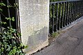
 Milestone outside Angiers Almshouses, Wallingford - geograph.org.uk - 1736518.jpg 1,071 × 1,600; 600 KB
-
 Water tower, Park Lane - geograph.org.uk - 2713746.jpg 683 × 1,024; 124 KB
-
-
 Wembley Fire Station - geograph.org.uk - 3845548.jpg 1,024 × 683; 135 KB
-
 York House, Bradford.jpg 1,024 × 683; 167 KB
-
 ^126 Avondale Road at York Street junction - geograph.org.uk - 5664655.jpg 1,024 × 683; 144 KB
-
 ^18 York Road - geograph.org.uk - 4352859.jpg 683 × 1,024; 223 KB
-
 ^36 York Road - geograph.org.uk - 4870469.jpg 672 × 1,024; 154 KB
-
 ^77 Canal Road and adjacent railway bridge - geograph.org.uk - 5291579.jpg 1,024 × 683; 185 KB


_-_geograph.org.uk_-_5664634.jpg)


_Offices,_Portway,_Wantage,_Oxon.jpg)


.jpg)


