Category:Illinois Secretary of State election maps (set)
Jump to navigation
Jump to search
States of the United States: Alabama · Arkansas · California · Idaho · Illinois · Indiana · Iowa · Kentucky · Michigan · Minnesota · New Mexico · North Dakota · Ohio · South Dakota · Washington · Wisconsin · Wyoming
Media in category "Illinois Secretary of State election maps (set)"
The following 11 files are in this category, out of 11 total.
-
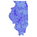
 1940 Illinois Secretary of State election.svg 800 × 1,435; 1.01 MB
-
 1964 Illinois Secretary of State election.svg 800 × 1,435; 1.01 MB
-
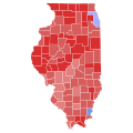 1994 Illinois Secretary of State election results map by county.svg 744 × 744; 284 KB
-
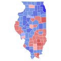
 1998 Illinois Secretary of State election results map by county.svg 744 × 744; 284 KB
-
 2002 Illinois Secretary of State election results map by county.svg 744 × 744; 284 KB
-
 2006 Illinois Secretary of State election results map by county.svg 744 × 744; 284 KB
-
 2010 Illinois Secretary of State election results map by county.svg 744 × 744; 284 KB
-
 2014 Illinois Secretary of State election results map by county.svg 744 × 744; 284 KB
-
 2018 Illinois Secretary of State election results map by county.svg 744 × 744; 284 KB
-
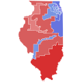 2022 Illinois Secretary of State election by CD.svg 810 × 810; 464 KB
-
 2022 Illinois Secretary of State election results map by county.svg 810 × 810; 43 KB


