Category:Idaho State Highway 14
Jump to navigation
Jump to search
 | number: | (fourteen) |
|---|---|---|
| State highways in Idaho: | 1 · 3 · 4 · 5 · 6 · 7 · 8 · 9 · 11 · 13 · 14 · 16 · 19 · 21 · 22 · 24 · 25 · 27 · 28 · 29 · 31 · 32 · 33 · 34 |
state highway in Idaho County, Idaho, United States .png) | |||||
| Upload media | |||||
| Instance of | |||||
|---|---|---|---|---|---|
| Located in protected area |
| ||||
| Location | Idaho County, Idaho | ||||
| Located in or next to body of water | |||||
| Transport network | |||||
| Owned by | |||||
| Maintained by | |||||
| Inception |
| ||||
| Length |
| ||||
| Terminus | |||||
 | |||||
English: Media related to Idaho State Highway 14, a 49.515-mile (79.687 km) state highway in Idaho County, Idaho, United States, that runs mostly along the Clearwater River, is almost entirely within the Kootenai National Forest, and connects Idaho State Highway 13 (south of Harpster) with Elk City.
Subcategories
This category has only the following subcategory.
Media in category "Idaho State Highway 14"
The following 4 files are in this category, out of 4 total.
-
 Idaho 14.svg 601 × 601; 2 KB
-
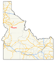 Highways in Idaho with SH 14 highlighted (2010 TL and 2005 NHPN).png 648 × 727; 126 KB
-
 ID-14.svg 600 × 600; 31 KB
-
 Idaho State Highway 14 (2010 TL and 2005 NHPN).png 1,335 × 727; 96 KB
.png)
