Category:Hypoberg
Jump to navigation
Jump to search
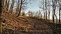
Artificial hill at the border of Unterföhring and Ismaning   | |||||
| Upload media | |||||
| Instance of |
| ||||
|---|---|---|---|---|---|
| Located in protected area | |||||
| Location |
| ||||
| Located in or next to body of water | |||||
| Elevation above sea level |
| ||||
 | |||||
Media in category "Hypoberg"
The following 5 files are in this category, out of 5 total.
-
 20161205Hypoberg 02.jpg 3,840 × 2,160; 2.46 MB
-
 20200228Landschaftsschutzgebiet Isar Landkreis München 01.jpg 5,965 × 3,988; 8.77 MB
-
 20210617 Hypoberg.jpg 5,855 × 3,909; 10.07 MB
-
 20221106 Hypoberg 01.jpg 4,295 × 2,867; 2.86 MB
-
 20221106 Hypoberg 03.jpg 2,137 × 1,427; 1.24 MB


