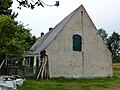
Category:Huthaus Prophet Daniel
Jump to navigation
Jump to search
| Object location | | View all coordinates using: OpenStreetMap |
|---|
house in Freiberg, Germany  | |||||
| Upload media | |||||
| Instance of | |||||
|---|---|---|---|---|---|
| Location | Freiberg, Mittelsachsen, Saxony, Germany | ||||
| Street address |
| ||||
| Heritage designation | |||||
| Inception |
| ||||
 | |||||
| (Wikidata) |
Media in category "Huthaus Prophet Daniel"
The following 12 files are in this category, out of 12 total.
-
 Freiberg Zug-Am Daniel,Huthaus.01.JPG 1,808 × 1,356; 885 KB
-
 Freiberg Zug-Am Daniel,Huthaus.03.JPG 1,808 × 1,356; 1.07 MB
-
 Freiberg Zug-Am Daniel,Huthaus.04.JPG 1,808 × 1,356; 1.08 MB
-
 Freiberg Zug-Am Daniel-Huthaus.02.JPG 1,808 × 1,356; 883 KB
-
 Huthaus Daniel Freiberg-Zug 01.JPG 4,320 × 2,432; 4.49 MB
-
 Huthaus Daniel Freiberg-Zug 02.JPG 4,320 × 2,432; 4.59 MB
-
 Huthaus Daniel Freiberg-Zug 03.JPG 4,320 × 2,432; 4.58 MB
-
 Huthaus Daniel Freiberg-Zug 04.JPG 2,560 × 1,920; 2.8 MB
-
 Huthaus Daniel Freiberg-Zug 05.JPG 4,320 × 3,240; 7.74 MB
-
 Huthaus Daniel Freiberg-Zug 06.JPG 4,320 × 2,432; 5.29 MB
-
 Huthaus Daniel Freiberg-Zug 07.JPG 4,320 × 2,432; 4.32 MB
-
 Huthaus Daniel Freiberg-Zug 08.JPG 2,560 × 1,920; 2.92 MB


