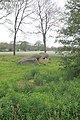
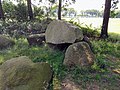
Category:Hunebed D51 in Noord-Sleen
Jump to navigation
Jump to search
| Object location | | View all coordinates using: OpenStreetMap |
|---|
dolmen in the Netherlands  | |||||
| Upload media | |||||
| Instance of | |||||
|---|---|---|---|---|---|
| Part of | |||||
| Location | Sleen, Sleen | ||||
| Street address |
| ||||
| Heritage designation |
| ||||
 | |||||
|
This is a category about rijksmonument number 46001
|
| Address |
|
Media in category "Hunebed D51 in Noord-Sleen"
The following 13 files are in this category, out of 13 total.
-
 D51 (hunebed).jpg 4,608 × 2,592; 6.49 MB
-
 Hunebed D51 - 1.JPG 4,272 × 2,848; 6.12 MB
-
 Hunebed D51 - 2.JPG 4,272 × 2,848; 5.9 MB
-
 Hunebed D51 - 3.JPG 4,272 × 2,848; 4.84 MB
-
 Hunebed D51 - 4.JPG 2,848 × 4,272; 5.54 MB
-
 Hunebed D51 - 5.JPG 4,272 × 2,848; 6.35 MB
-
 Hunebed D51 - 6.JPG 2,848 × 4,272; 5.97 MB
-
 Hunebed D51 bij Noord-Sleen.jpg 1,296 × 972; 283 KB
-
 Hunebed D51 Goedeljee.jpg 2,000 × 1,554; 731 KB
-
 Hunebed D51 in Noord-Sleen.jpg 4,032 × 3,024; 6.3 MB
-
 Hunebed D51 Noord-Sleen (4868466357) (2).jpg 4,000 × 3,000; 2.72 MB
-
 Hunebed D51.jpg 4,032 × 3,024; 4.95 MB
-
 HunebedD51.jpg 4,000 × 3,000; 5.86 MB
.jpg)


_(2).jpg)

