Category:Hunebed D10 in Gasterse Duinen
Jump to navigation
Jump to search
| Object location | | View all coordinates using: OpenStreetMap |
|---|
dolmen in the Netherlands ,_hunebed_D10.jpg) | |||||
| Upload media | |||||
| Instance of | |||||
|---|---|---|---|---|---|
| Part of | |||||
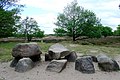
| Location | Gasteren, Aa en Hunze, Drenthe, Netherlands | ||||
| Street address |
| ||||
| Heritage designation |
| ||||
| Different from | |||||
 | |||||
|
This is a category about rijksmonument number 45015
|
| Address |
|
Media in category "Hunebed D10 in Gasterse Duinen"
The following 5 files are in this category, out of 5 total.
-
 Hunebed D10 bij Gasteren.jpg 2,589 × 1,716; 637 KB
-
 Hunebed, gelegen in de Gasterse Duinen - Gasteren - 20528291 - RCE.jpg 1,200 × 800; 293 KB
-
 Hunebed, gelegen in de Gasterse Duinen - Gasteren - 20528292 - RCE.jpg 1,200 × 799; 271 KB
-
 Netherlands, Drenthe, Gasterse duinen (3), hunebed D10.jpg 4,032 × 3,024; 10.16 MB
-
 Zicht op hunebed, gelegen in de Gasterse Duinen - Gasteren - 20528290 - RCE.jpg 1,200 × 538; 205 KB


