Category:Hulme Walfield
Jump to navigation
Jump to search
English: Hulme Walfield is a small village and civil parish, just north of Congleton, in the unitary authority of Cheshire East and the ceremonial county of Cheshire. It is home to most of Westlow Mere. According to the 2001 census, the population of the civil parish was 140.
village and civil parish in Cheshire East, Cheshire, UK  | |||||
| Upload media | |||||
| Instance of | |||||
|---|---|---|---|---|---|
| Location | Cheshire East, Cheshire, North West England, England | ||||
 | |||||
Media in category "Hulme Walfield"
The following 22 files are in this category, out of 22 total.
-
 A34 near Sandhole Farm - geograph.org.uk - 4146047.jpg 640 × 480; 311 KB
-
 A34 north of Sandhole Farm - geograph.org.uk - 3416047.jpg 640 × 480; 62 KB
-

-

-

-
 Brick House Farm, Hulme Walfield 01.jpg 4,000 × 3,000; 1.38 MB
-
 Brick House Farm, Hulme Walfield 02.jpg 4,000 × 3,000; 1.86 MB
-
 Congleton Road - geograph.org.uk - 4146060.jpg 640 × 480; 330 KB
-

-
 Focus DIY - geograph.org.uk - 1933676.jpg 2,048 × 1,536; 513 KB
-

-
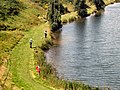 Hulme Walfield - Westlow Mere.jpg 640 × 480; 156 KB
-
 Large pond at Sandhole farm - geograph.org.uk - 1026067.jpg 640 × 459; 71 KB
-
 Modern Standing Stones - geograph.org.uk - 158134.jpg 640 × 480; 108 KB
-
 Oak tree and pond - geograph.org.uk - 442922.jpg 640 × 480; 76 KB
-

-
 Sandhole Farm and rape seed crop - geograph.org.uk - 4462090.jpg 4,320 × 3,240; 5.48 MB
-
 Smithy Lane looking east - geograph.org.uk - 3416040.jpg 640 × 480; 82 KB
-
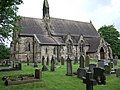 St Michael's Church - geograph.org.uk - 473343.jpg 640 × 480; 98 KB
-
 The Hall, Hulme Walfield - geograph.org.uk - 473338.jpg 640 × 480; 95 KB
-
 The Waggon and Horses pub - geograph.org.uk - 4462070.jpg 4,320 × 3,240; 3.89 MB
-
 Turf production at Sandhole Farm - geograph.org.uk - 1026077.jpg 640 × 342; 57 KB


