Category:Houtse Heuvel 24a, Den Hout
Jump to navigation
Jump to search
| Object location | | View all coordinates using: OpenStreetMap |
|---|
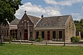
{{nl|Afbeeldingen van het Dorpshuis Den Brink, Houtse Heuvel 24a, 4911 AW Den Hout. Gelegen in Den Hout, een dorp behorende tot de gemeente Oosterhout in de provincie Noord-Brabant in het zuiden van Nederland. Het is een gemeentelijk monument. (bron [1])
|
This is a category about a municipal monument in Oosterhout with number 2002-07 |
Media in category "Houtse Heuvel 24a, Den Hout"
The following 8 files are in this category, out of 8 total.
-
 08262002-07 R.K. verenigingsgbouw Den Hout.jpg 3,000 × 2,000; 5.2 MB
-
 Dorpshuis Den Brink DSCF8527.jpg 2,816 × 1,864; 2.53 MB
-
 Dorpshuis Den Brink DSCF8528.jpg 1,864 × 2,816; 2.5 MB
-
 Exterieur dorpsgezicht r.k. verenigingsgebouw - Den Hout - 20000915 - RCE.jpg 1,200 × 895; 343 KB
-
 Exterieur dorpsgezicht r.k. verenigingsgebouw - Den Hout - 20000916 - RCE.jpg 1,200 × 889; 296 KB
-
 Exterieur dorpsgezicht r.k. verenigingsgebouw - Den Hout - 20000917 - RCE.jpg 1,200 × 1,193; 356 KB
-
 P1020357 copy2.jpg 3,264 × 2,448; 1.41 MB
-
 P1020358Den Hout.JPG 3,264 × 2,448; 3.76 MB


