Category:House of children and youth in Jablunkov
Jump to navigation
Jump to search
| Object location | | View all coordinates using: OpenStreetMap |
|---|
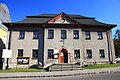
Polski: Jabłonków, dom dzieci i młodzieży, były ratusz (dom nr 143)
Čeština: Jablunkov, dům dětí a mládeže, bývalá radnice (čp.143)
English: Jablunkov, house of children and youth, former town hall (house number 143)
Media in category "House of children and youth in Jablunkov"
The following 4 files are in this category, out of 4 total.
-
 2013 Jabłonków, Dom dzieci i młodzieży 01.jpg 4,472 × 2,980; 10.58 MB
-
 2013 Jabłonków, Dom dzieci i młodzieży 02.jpg 4,459 × 2,973; 11.15 MB
-
 2013 Jabłonków, Dom dzieci i młodzieży 03.jpg 4,316 × 2,877; 10.22 MB
-
 2013 Jabłonków, Dom dzieci i młodzieży 04.jpg 4,060 × 2,707; 10.14 MB


