Category:Hoofdweg 23 (Peest)
Jump to navigation
Jump to search
| Object location | | View all coordinates using: OpenStreetMap |
|---|
 | |||||
| Upload media | |||||
| Instance of | |||||
|---|---|---|---|---|---|
| Part of | |||||
| Location | Peest, Noordenveld, Drenthe, Netherlands | ||||
| Located on street |
| ||||
| Heritage designation |
| ||||
 | |||||
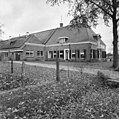
Nederlands: Hoofdweg 23, Peest (gem. Noordenveld, Drenthe), rmc 469393. Dit rijksmonumentcomplex omvat:
- woonhuis boerderij (ca. 1855, rm 469394)
- vrijstaande bijschuur (1935, rm 469395)
|
This is a category about rijksmonumentcomplex number 469393
|
|
This is a category about rijksmonument number 469394
|
|
This is a category about rijksmonument number 469395
|
Media in category "Hoofdweg 23 (Peest)"
The following 25 files are in this category, out of 25 total.
-

-

-
 Hoofdweg 23 (vooraanzicht).jpg 4,449 × 3,337; 2.73 MB
-
 Hoofdweg 23 (zijaanzicht).jpg 4,608 × 3,456; 3.81 MB
-

-
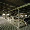
 Interieur, overzicht van de deel met gebintstellen - Peest - 20390546 - RCE.jpg 1,200 × 960; 267 KB
-
-
 Overzicht - Peest - 20181648 - RCE.jpg 1,200 × 1,200; 504 KB
-

-

-

-

-

-

-
 Overzicht van de linker zijgevel - Peest - 20390232 - RCE.jpg 1,200 × 960; 272 KB
-

-

-

-
 Overzicht, gezien vanaf de overkant van de Hoofdweg - Peest - 20390233 - RCE.jpg 1,200 × 1,200; 465 KB
-
 Overzicht, gezien vanuit het zuidoosten - Peest - 20390235 - RCE.jpg 1,200 × 960; 261 KB
-
 Voor- en linker zijgevel - Peest - 20181649 - RCE.jpg 1,195 × 1,200; 429 KB
-
 Voor- en rechter zijgevel - Peest - 20181650 - RCE.jpg 1,195 × 1,200; 535 KB
-
 Zij- en voorgevel nr. F 174-19 - Peest - 20490632 - RCE.jpg 1,200 × 900; 187 KB
-
 Zijgevel bedr.ged. nr. F 174-18 - Peest - 20490634 - RCE.jpg 1,200 × 900; 178 KB
-
 Zijgevel Foto uit de krant ? - Peest - 20490633 - RCE.jpg 1,200 × 900; 139 KB


.jpg)
.jpg)


