Category:Hoofdweg 13 (Westervelde)
Jump to navigation
Jump to search
| Object location | | View all coordinates using: OpenStreetMap |
|---|
 | |||||
| Upload media | |||||
| Instance of | |||||
|---|---|---|---|---|---|
| Part of | |||||
| Location | Westervelde, Noordenveld, Drenthe, Netherlands | ||||
| Located on street |
| ||||
| Heritage designation |
| ||||
 | |||||
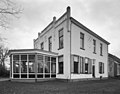
Nederlands: Herenhuis/boerderij De Jufferen Lunsingh, Westervelde
|
This is a category about rijksmonumentcomplex number 469380
|
Boerderij/herenhuis
|
This is a category about rijksmonument number 469381
|
Stookhok
|
This is a category about rijksmonument number 469382
|
| Address |
|
Media in category "Hoofdweg 13 (Westervelde)"
The following 10 files are in this category, out of 10 total.
-
 Achtergevel - Westervelde - 20254465 - RCE.jpg 1,200 × 1,200; 367 KB
-
 Bakhuisje van de boerderij Hoofdweg 13.jpg 4,608 × 3,456; 3.28 MB
-
 Boerderij Hoofdweg 13 (noordoostzijde).jpg 4,608 × 3,456; 2.83 MB
-
-
 Exterieur woonhuis, voorgevel - Westervelde - 20321860 - RCE.jpg 1,200 × 952; 209 KB
-
 Overzicht - Westervelde - 20254460 - RCE.jpg 1,200 × 954; 310 KB
-
 Overzicht - Westervelde - 20254461 - RCE.jpg 1,192 × 1,200; 340 KB
-
 Overzicht - Westervelde - 20254462 - RCE.jpg 1,190 × 1,200; 400 KB
-
 Voor- en zijgevel - Westervelde - 20254464 - RCE.jpg 1,186 × 1,200; 370 KB
-
 Voorgevel - Westervelde - 20254463 - RCE.jpg 1,181 × 1,200; 344 KB


.jpg)


