Category:Hollerwettern range front light
Jump to navigation
Jump to search
| Object location | | View all coordinates using: OpenStreetMap |
|---|
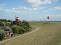
lighthouse in Schleswig-Holstein, Germany  | |||||
| Upload media | |||||
| Instance of | |||||
|---|---|---|---|---|---|
| Part of |
| ||||
| Made from material | |||||
| Location | Wewelsfleth, Steinburg, Schleswig-Holstein, Germany | ||||
| Located in or next to body of water | |||||
| Has use |
| ||||
| Inception |
| ||||
| Height |
| ||||
 | |||||
Media in category "Hollerwettern range front light"
The following 2 files are in this category, out of 2 total.
-
 Hollerwettern Unterfeuer.jpg 2,736 × 3,648; 2.33 MB
-
 Wewelsfleth Leuchtturm-und-Unterfeuer-Hollerwettern Juli-2010 SL274818.JPG 3,072 × 2,304; 2.77 MB

Categories:
- Lighthouses in Germany by name
- Lighthouses in Schleswig-Holstein
- Range lights in Germany
- Lighthouses by height, 21 to 30 meters
- Lighthouses built in 1982
- Concrete lighthouses in Germany
- Wasserstraßen- und Schifffahrtsamt Hamburg
- Wewelsfleth
- Red and white lighthouses in Germany
- Lighthouses by range, 10 to 14 nm