Category:Hoi Bun Road Park
Jump to navigation
Jump to search
| Object location | | View all coordinates using: OpenStreetMap |
|---|
public park in Kwun Tong, Hong Kong  | |||||
| Upload media | |||||
| Instance of | |||||
|---|---|---|---|---|---|
| Location | |||||
 | |||||
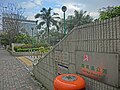
English: Hoi Bun Road Park, Hoi Bun Road, Kwun Tong, Hong Kong
Media in category "Hoi Bun Road Park"
The following 14 files are in this category, out of 14 total.
-
-
 HK 觀塘 Kwun Tong 海濱道公園 Hoi Bun Road Park LCSD Dec-2013 name signs Wai Yip Street.JPG 2,048 × 1,536; 2.51 MB
-
 HK 觀塘 Kwun Tong 海濱道公園 Hoi Bun Road Park LCSD Dec-2013 Panoramics view.JPG 11,520 × 1,080; 8.09 MB
-
 HK 觀塘 Kwun Tong 海濱道公園 Hoi Bun Road Park LCSD Dec-2013 pavillion n COL Tower.JPG 2,048 × 1,536; 2.49 MB
-

-
 HK 觀塘 Kwun Tong 海濱道公園 Hoi Bun Road Park LCSD Dec-2013 view COL Tower.JPG 2,048 × 1,536; 3.14 MB
-

-
 HK 觀塘 Kwun Tong 海濱道公園 Hoi Bun Road Park LCSD Dec-2013 view Wai Yip Street facade HECNY.JPG 2,048 × 1,536; 2.72 MB
-

-
 HK 觀塘 Kwun Tong 海濱道公園 Hoi Bun Road Park LCSD Dec-2013 view Wai Yip Street.JPG 2,048 × 1,536; 2.91 MB
-
 HK 觀塘 Kwun Tong 海濱道公園 Hoi Bun Road Park LCSD Dec-2013 Wai Yip Street.JPG 2,048 × 1,536; 2.95 MB
-
 HK 觀塘 Kwun Tong 海濱道公園 Hoi Bun Road Park LCSD Dec-2013 white flower.JPG 2,048 × 1,536; 2.13 MB
-
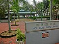 HK 觀塘 Kwun Tong 海濱道公園 Hoi Bun Road Park name sign LCSD Dec-2013 Wai Yip Street.JPG 2,048 × 1,536; 2.75 MB
-
 Hoi Bun Road Park.jpg 3,264 × 2,448; 1.56 MB


