Category:Hoge der A 30 (Groningen)
Jump to navigation
Jump to search
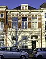
Nederlands: Hoge der A 30, Groningen (gem.mon. 102398)
| Object location | | View all coordinates using: OpenStreetMap |
|---|
|
This is a category about a municipal monument in Groningen with number 102398 |
Media in category "Hoge der A 30 (Groningen)"
The following 4 files are in this category, out of 4 total.
-
 Eind, voorgevels - Groningen - 20093977 - RCE.jpg 1,200 × 807; 247 KB
-
 Groningen Hooge der A 30.jpg 2,446 × 3,632; 2.52 MB
-
 Hoge der A 30.jpg 2,770 × 3,585; 6.41 MB
-
 Voorgevel - Groningen - 20093976 - RCE.jpg 816 × 1,200; 233 KB


