Category:Hochofen in Urtlgraben, Guttaring
Jump to navigation
Jump to search
| This category shows the protected monument with the number 34373 in Austria. (Commons, de, Wikidata) |
| Object location | | View all coordinates using: OpenStreetMap |
|---|
historic monument  | |||||
| Upload media | |||||
| Instance of | |||||
|---|---|---|---|---|---|
| Location | Guttaring, Sankt Veit an der Glan District, Carinthia, Austria | ||||
| Street address |
| ||||
| Heritage designation | |||||
 | |||||
Media in category "Hochofen in Urtlgraben, Guttaring"
The following 7 files are in this category, out of 7 total.
-
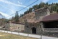
 Guttaring Urtlgraben 9 Verweserhaus und Hochofen N-Ansicht 21032017 6794.jpg 7,360 × 4,912; 24.49 MB
-
 Guttaring Urtlgraben 9 Verweserhaus und Hochofen N-Ansicht 21032017 6796.jpg 7,360 × 4,912; 31.83 MB
-
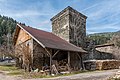
 Guttaring Urtlgraben Hochofen ehem Floßofen NW-Ansicht 21032017 6791.jpg 7,318 × 4,884; 22.64 MB
-
 Guttaring Urtlgraben Hochofen ehem Floßofen NW-Ansicht 21032017 6792.jpg 7,360 × 4,912; 32.23 MB
-
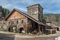
 Guttaring Urtlgraben Hochofen ehem Floßofen SO-Ansicht 21032017 6787.jpg 6,790 × 4,532; 19.73 MB
-
 Guttaring Urtlgraben Hochofen ehem Floßofen SO-Ansicht 21032017 6789.jpg 7,331 × 4,912; 22.86 MB
-
 Hochofen-Urtl-Guttaring.JPG 1,955 × 1,536; 1.47 MB


