Category:Hindenburgturm (Bexbach)
Jump to navigation
Jump to search
| Object location | | View all coordinates using: OpenStreetMap |
|---|
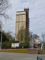
water tower and observation tower in Bexbach, Saarland  | |||||
| Upload media | |||||
| Instance of | |||||
|---|---|---|---|---|---|
| Named after | |||||
| Location | Bexbach, Saarpfalz-Kreis, Saarland, Germany | ||||
| Start time |
| ||||
 | |||||
Media in category "Hindenburgturm (Bexbach)"
The following 6 files are in this category, out of 6 total.
-
 Bexbach Hindenburgturm.jpg 1,500 × 2,000; 946 KB
-
 Bexbacher Hindenburgturm.jpg 1,456 × 2,592; 1.69 MB
-
 Hindenburgturm (Bexbach)-01.jpg 3,240 × 4,320; 5.1 MB
-
 Hindenburgturm (Bexbach)-02.jpg 3,240 × 4,320; 4.98 MB
-
 Hindenburgturm Bexbach.jpg 3,024 × 3,318; 2.77 MB
-
 Saar 1951 307 Hindenburgturm Bexbach - Garten und Blumen.jpg 670 × 1,000; 547 KB

-01.jpg)
-02.jpg)

