Category:Higher Lane entrance to Everton Cemetery
Jump to navigation
Jump to search
| Object location | | View all coordinates using: OpenStreetMap |
|---|
Subcategories
This category has only the following subcategory.
Media in category "Higher Lane entrance to Everton Cemetery"
The following 2 files are in this category, out of 2 total.
-
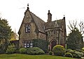 Lodge at Higher Lane entrance to Everton Cemetery.jpg 4,670 × 3,309; 12.66 MB
-
 West lodge at Higher Lane entrance to Everton Cemetery.jpg 4,826 × 3,402; 17.47 MB

