Category:Heriot, Scottish Borders
Jump to navigation
Jump to search
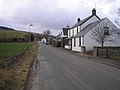
English: Heriot is a small village in the Moorfoot Hills southeast of Edinburgh, Scotland, within Eildon (part of the Scottish Borders council area). The village comprises some 170 dwellings, spread over a geographical area of around 50 square miles, most of which is moorland. Connected to the rest of the world primarily through the A7 road, Heriot had a railway and station from 1849 until the branch line closures instigated by Beeching caused the track to be uplifted in the 1960s. The Scottish Parliament voted, in 2006, to reinstate the railway, but without a station at Heriot.
village in Scottish Borders, Scotland, UK | |||||
| Upload media | |||||
| Instance of | |||||
|---|---|---|---|---|---|
| Location |
| ||||
 | |||||
Media in category "Heriot, Scottish Borders"
The following 76 files are in this category, out of 76 total.
-
 Borders Railway, Heriot.jpg 800 × 600; 492 KB
-
 Brothershiels - geograph.org.uk - 401848.jpg 640 × 451; 56 KB
-
 Dewy Dragonfly - Flickr - S. Rae.jpg 1,114 × 1,078; 289 KB
-
 Eupeodes corollae (female) - Flickr - S. Rae (5).jpg 714 × 602; 164 KB
-
 Halltree - geograph.org.uk - 208751.jpg 640 × 480; 84 KB
-
 Heriot (at Heriot Station) - geograph.org.uk - 352059.jpg 640 × 480; 75 KB
-
 Heriot - geograph.org.uk - 37983.jpg 640 × 480; 108 KB
-
 Heriot Kirk.jpg 640 × 480; 116 KB
-
 House at Hangingshaw - geograph.org.uk - 569266.jpg 640 × 480; 123 KB
-
 Nettingflat - geograph.org.uk - 175725.jpg 640 × 480; 52 KB
-
 Parasyrphus lineolus (male) - Flickr - S. Rae (1).jpg 606 × 542; 132 KB
-
 Parasyrphus lineolus (male) - Flickr - S. Rae (2).jpg 1,316 × 1,172; 448 KB
-
 Parasyrphus lineolus (male) - Flickr - S. Rae (4).jpg 1,428 × 1,101; 353 KB
-
 Parasyrphus lineolus (male) - Flickr - S. Rae (5).jpg 876 × 756; 182 KB
-
 Road off Rawburn Head - geograph.org.uk - 292946.jpg 640 × 480; 78 KB
-
 The wee burn - geograph.org.uk - 760654.jpg 640 × 480; 95 KB
-
 Track, Shoestanes. - geograph.org.uk - 115723.jpg 640 × 454; 76 KB
-
 Whiteside Law and the Blackhope Water - geograph-4686300.jpg 1,024 × 678; 166 KB
-
 A thicket of evergreens - geograph.org.uk - 761835.jpg 640 × 480; 78 KB
-
 A welcome rest - geograph.org.uk - 761822.jpg 640 × 480; 103 KB
-
 Above Shoestanes. - geograph.org.uk - 111733.jpg 640 × 480; 74 KB
-
 Across the Shiel Burn - geograph.org.uk - 292922.jpg 640 × 480; 92 KB
-
 Bog hole, Ladyside Height - geograph.org.uk - 292517.jpg 640 × 480; 79 KB
-
 Brothershiels - geograph.org.uk - 435594.jpg 640 × 480; 63 KB
-
 Butt with a view - geograph.org.uk - 292934.jpg 640 × 480; 67 KB
-
 Buy a byre - geograph.org.uk - 560710.jpg 625 × 477; 69 KB
-

-
 Cattle, Corsehope - geograph.org.uk - 312682.jpg 640 × 480; 74 KB
-
 Corshope Farm - geograph.org.uk - 208699.jpg 640 × 480; 74 KB
-
 Descent to Ladyside - geograph.org.uk - 292955.jpg 640 × 480; 82 KB
-
 Dewar - geograph.org.uk - 292233.jpg 640 × 480; 107 KB
-
 Dewar Gill - geograph.org.uk - 322228.jpg 640 × 480; 53 KB
-
 Dewar Hill - geograph.org.uk - 292228.jpg 640 × 480; 104 KB
-
 Dewar Hill - geograph.org.uk - 292236.jpg 639 × 448; 90 KB
-
 Dewar Hill - geograph.org.uk - 292258.jpg 640 × 480; 115 KB
-
 Dewar Hill - geograph.org.uk - 292263.jpg 640 × 480; 108 KB
-
 Early cut - geograph.org.uk - 208745.jpg 640 × 480; 86 KB
-
 Falahill - geograph.org.uk - 559756.jpg 640 × 451; 59 KB
-
 Fence junction, Ladyside Heights. - geograph.org.uk - 292497.jpg 640 × 480; 109 KB
-
 Frozen pond, Heriot. - geograph.org.uk - 115716.jpg 640 × 480; 69 KB
-
 Gala Water - geograph.org.uk - 561621.jpg 640 × 480; 82 KB
-
 Gala Water - geograph.org.uk - 760638.jpg 640 × 480; 64 KB
-
 Garvald - geograph.org.uk - 292219.jpg 640 × 480; 67 KB
-
 Grouse grit - Dewar Hill - geograph.org.uk - 292268.jpg 640 × 480; 120 KB
-
 Head of White Cleuch - geograph.org.uk - 292265.jpg 640 × 480; 93 KB
-
 Heriot - geograph.org.uk - 760659.jpg 640 × 480; 46 KB
-
 Heriot - geograph.org.uk - 761812.jpg 640 × 480; 128 KB
-
 Heriot Water - geograph.org.uk - 312670.jpg 640 × 480; 122 KB
-
 Lady's Wood. - geograph.org.uk - 115715.jpg 640 × 459; 56 KB
-
 Ladyside Burn - geograph.org.uk - 292508.jpg 640 × 480; 95 KB
-
 Ladyside Burn - geograph.org.uk - 292962.jpg 480 × 640; 103 KB
-
 Ladyside Burn - geograph.org.uk - 292964.jpg 640 × 480; 94 KB
-
 Longshaw - geograph.org.uk - 292224.jpg 640 × 480; 97 KB
-
 March fence, Burntshiel Rig - geograph.org.uk - 322222.jpg 640 × 480; 73 KB
-
 Newly cut grass - geograph.org.uk - 208742.jpg 640 × 480; 87 KB
-
 North ridge of Dewar Hill - geograph.org.uk - 292227.jpg 639 × 460; 67 KB
-

-
 Railway shed, Garvald. - geograph.org.uk - 292205.jpg 640 × 480; 106 KB
-
 Raw Burn - geograph.org.uk - 292959.jpg 640 × 480; 86 KB
-
 Rawburn and Ladyside Burn meet - geograph.org.uk - 292958.jpg 640 × 480; 86 KB
-
 Rawburn Head - geograph.org.uk - 292943.jpg 640 × 480; 81 KB
-
 Rawburn Head - geograph.org.uk - 292948.jpg 640 × 480; 94 KB
-
 Rawburn Head - geograph.org.uk - 292950.jpg 640 × 433; 80 KB
-
 Repeater mast, Ladyside Heights - geograph.org.uk - 292534.jpg 638 × 451; 54 KB
-
 Road over Rawburn Head - geograph.org.uk - 292953.jpg 640 × 480; 67 KB
-
 Round bales, Heriot Cleuch. - geograph.org.uk - 111767.jpg 640 × 480; 67 KB
-
 Sheep, Falahill - geograph.org.uk - 558495.jpg 640 × 480; 73 KB
-
 Sheep, Heriot - geograph.org.uk - 560714.jpg 640 × 480; 61 KB
-
 Shoestanes Burn. - geograph.org.uk - 111774.jpg 640 × 480; 75 KB
-
 Shoestanes' sheep. - geograph.org.uk - 111730.jpg 640 × 428; 55 KB
-
 Sole Burn - geograph.org.uk - 292522.jpg 640 × 480; 79 KB
-

-
 The Sole - geograph.org.uk - 292514.jpg 640 × 480; 78 KB
-
 Track to Corsehope - geograph.org.uk - 312679.jpg 640 × 480; 85 KB
-
 White Hill - geograph.org.uk - 208746.jpg 640 × 480; 85 KB
-
 Windy Knowe - geograph.org.uk - 69597.jpg 640 × 384; 38 KB


_-_Flickr_-_S._Rae_(5).jpg)

_-_geograph.org.uk_-_352059.jpg)


_-_Flickr_-_S._Rae_(1).jpg)
_-_Flickr_-_S._Rae_(2).jpg)
_-_Flickr_-_S._Rae_(4).jpg)
_-_Flickr_-_S._Rae_(5).jpg)


