Category:Hereweg 111 (Groningen)
Jump to navigation
Jump to search
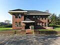
Nederlands: Hereweg 111, Groningen (1934, H. Hoekstra, gem.mon. 106343)
| Object location | | View all coordinates using: OpenStreetMap |
|---|
|
This is a category about a municipal monument in Groningen with number 106343 |
Media in category "Hereweg 111 (Groningen)"
The following 4 files are in this category, out of 4 total.
-
 20110709 Hereweg 111 Groningen NL.jpg 4,500 × 2,700; 3.4 MB
-
 20110923 Hereweg 111 Groningen NL.jpg 5,000 × 3,000; 11.39 MB
-
 20110925 Hereweg 111 Groningen NL (2).jpg 6,000 × 4,500; 8.23 MB
-
 20110925 Hereweg 111 Groningen NL.jpg 3,500 × 2,100; 2.74 MB


.jpg)
