Category:Hengelosestraat 2, Delden
Jump to navigation
Jump to search
| Object location | | View all coordinates using: OpenStreetMap |
|---|
building in Hof van Twente, Netherlands  | |||||
| Upload media | |||||
| Instance of | |||||
|---|---|---|---|---|---|
| Location | Delden, Overijssel, Netherlands | ||||
| Street address |
| ||||
| Located on street |
| ||||
| Occupant | |||||
| Heritage designation |
| ||||
 | |||||
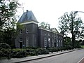
Nederlands: Cramershof
|
This is a category about rijksmonument number 34146
|
| Address |
|
Media in category "Hengelosestraat 2, Delden"
The following 5 files are in this category, out of 5 total.
-
 2020-08-04 — Museum No Hero – 05.jpg 4,000 × 3,000; 3.33 MB
-
 Aanzicht - Ambt Delden - 20008185 - RCE.jpg 1,200 × 802; 172 KB
-
 Delden hengelosestraat 2 4 rentmeesterij.jpg 1,280 × 960; 1.18 MB
-
 DeldenRentmeesterij2017.jpg 5,472 × 3,648; 6.29 MB
-
 Voorgevel - Delden - 20048204 - RCE.jpg 1,200 × 806; 253 KB


