Category:Heilige Hart (Breda)
Jump to navigation
Jump to search
| Object location | | View all coordinates using: OpenStreetMap |
|---|
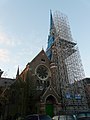
Nederlands: Afbeeldingen van de voormalige Heilige Hartkerk, Baronielaan 22, 4818 RA Breda. Gelegen in de wijk Zandberg in Breda in de provincie Noord-Brabant in het zuiden van Nederland. Het is een rijksmonument. Tegenwoordig zijn er appartementen in de kerk gemaakt
|
This is a category about rijksmonument number 519134
|
 | |||||
| Upload media | |||||
| Instance of |
| ||||
|---|---|---|---|---|---|
| Part of | |||||
| Location | Breda, North Brabant, Netherlands | ||||
| Street address |
| ||||
| Architect | |||||
| Heritage designation |
| ||||
| Religion or worldview | |||||
 | |||||
Subcategories
This category has only the following subcategory.
I
- Interior of Heilige Hart (Breda) (13 F)
Media in category "Heilige Hart (Breda)"
The following 29 files are in this category, out of 29 total.
-
 13-06-27-breda-by-RalfR-103.jpg 2,848 × 4,288; 7.7 MB
-
 519134 Heilig Hartkerk Breda.jpg 5,916 × 4,568; 16.8 MB
-
 Baronielaan P1160389.jpg 5,328 × 1,920; 5.73 MB
-
 Church Tower Window View (165871101).jpeg 2,048 × 1,314; 1.07 MB
-
 Detail Heilige Hartkerk Breda P1160398.jpg 2,672 × 4,000; 5.83 MB
-
 Detail Heilige Hartkerk Breda P1160399.jpg 4,000 × 2,672; 5.62 MB
-
 Detail Heilighartkerk Breda P1160397.jpg 4,000 × 2,672; 5.8 MB
-
 Exterieur NOORDGEVEL - Breda - 20311184 - RCE.jpg 795 × 1,200; 270 KB
-
 Exterieur OVERZICHT NOORDGEVEL, OOSTGEVEL - Breda - 20311182 - RCE.jpg 795 × 1,200; 227 KB
-
 Exterieur PASTORIE, VOORGEVEL - Breda - 20311185 - RCE.jpg 795 × 1,200; 164 KB
-
 Exterieur WESTGEVEL - Breda - 20311181 - RCE.jpg 795 × 1,200; 204 KB
-
 Heilig Hartkerk - Breda - 20311179 - RCE.jpg 795 × 1,200; 168 KB
-
 Heilig Hartkerk - Breda - 20311180 - RCE.jpg 795 × 1,200; 183 KB
-
 Heilig Hartkerk - Breda - 20311183 - RCE.jpg 795 × 1,200; 270 KB
-
 Heilig Hartkerk Baronielaan 22, Breda.jpg 2,048 × 3,072; 1.45 MB
-
 Heilige Hart (Breda) P1600043.jpg 2,672 × 4,000; 5.43 MB
-
 Heilige Hartkerk Breda P1160381.jpg 4,000 × 2,672; 5.95 MB
-
 Heilige Hartkerk Breda P1160382.jpg 2,672 × 4,000; 6.05 MB
-
 Heilige Hartkerk Breda P1160383.jpg 2,672 × 4,000; 5.73 MB
-
 Heilige Hartkerk Breda P1160390.jpg 2,672 × 4,000; 5.56 MB
-
 Heilige Hartkerk Breda P1160392.jpg 2,672 × 4,000; 5.64 MB
-
 Heilige Hartkerk Breda P1160393.jpg 2,672 × 4,000; 5.66 MB
-
 Heilige Hartkerk Breda P1160394.jpg 2,672 × 4,000; 6.08 MB
-
 Heilige Hartkerk Breda P1160395.jpg 2,672 × 4,000; 5 MB
-
 Heilige Hartkerk Breda P1160401.jpg 2,672 × 4,000; 5.81 MB
-
 Informatiebord P1160402.jpg 4,000 × 2,672; 5.63 MB
-
 Overzicht naar het westen - Breda - 20346801 - RCE.jpg 1,167 × 1,200; 259 KB
-
 P1010513copyHeilig Hartkerk.jpg 2,448 × 3,264; 1.97 MB
-
 Toren Heilige Hartkerk Breda P1160400.jpg 2,672 × 4,000; 6.02 MB


.jpeg)


_P1600043.jpg)


