Category:Health maps of New Zealand
Jump to navigation
Jump to search
Subcategories
This category has only the following subcategory.
Media in category "Health maps of New Zealand"
The following 20 files are in this category, out of 20 total.
-
 Auckland District Health Board map.svg 650 × 846; 133 KB
-
 Bay of Plenty District Health Board map.svg 650 × 846; 133 KB
-
 Canterbury District Health Board map.svg 650 × 846; 133 KB
-
 Capital and Coast District Health Board map.svg 650 × 846; 133 KB
-
 New Zealand District Health Board Map (Blank).svg 650 × 846; 133 KB
-
 New Zealand District Health Board Map 2001–10 (Blank).svg 750 × 846; 140 KB
-
 New Zealand District Health Board Map 2010–15 (Blank).svg 750 × 846; 140 KB
-
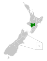
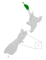 Northland District Health Board map.svg 650 × 846; 133 KB
-
 Otago District Health Board map.svg 750 × 846; 140 KB
-
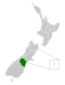 South Canterbury District Health Board map.svg 650 × 846; 133 KB
-
 Southern District Health Board map.svg 650 × 846; 133 KB
-
 Southland District Health Board map.svg 750 × 846; 140 KB
-
 Swine Flu map NZ.PNG 405 × 590; 12 KB
-
 Tairawhiti District Health Board map.svg 650 × 846; 133 KB
-
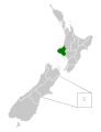 Taranaki District Health Board map.svg 650 × 846; 133 KB
-
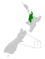 Waikato District Health Board map.svg 650 × 846; 133 KB
-
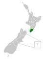 Wairarapa District Health Board map.svg 650 × 846; 133 KB
-
 Waitemata District Health Board map.svg 650 × 846; 133 KB
-
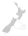
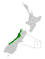 West Coast District Health Board map.svg 650 × 846; 133 KB
-
 Whanganui District Health Board map.svg 650 × 846; 133 KB


.svg)
.svg)
.svg)