Category:Hauptstraße 27 (Marktsteft)
Jump to navigation
Jump to search
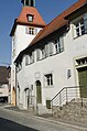
This is the category of the Bavarian Baudenkmal (cultural heritage monument) with the ID D-6-75-149-9 (Wikidata)
|
| Object location | | View all coordinates using: OpenStreetMap |
|---|
Deutsch: Rathaus. Zweigeschossiger traufständiger Satteldachbau, bezeichnet „1609“; mit Turm und Durchfahrt. Hauptstraße 27; Nähe Hauptstraße, Marktsteft, Landkreis Kitzingen, Unterfranken, Deutschland.
Media in category "Hauptstraße 27 (Marktsteft)"
The following 2 files are in this category, out of 2 total.
-
 Marktsteft, Hauptstraße 27, 001.jpg 3,264 × 4,928; 6.67 MB
-
 Marktsteft, Hauptstraße 27, 002.jpg 3,264 × 4,928; 7.77 MB

