Category:Hardy Dam, taken by Lar
Jump to navigation
Jump to search
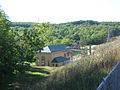
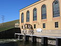
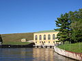
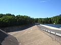
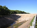
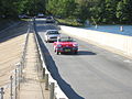
Images of, or related to, the Hardy Dam, a dam and powerplant complex, built 1907, on the Muskegon River in Big Prairie Township, Newaygo County, Michigan, taken by User:Lar |
 |
Media in category "Hardy Dam, taken by Lar"
The following 14 files are in this category, out of 14 total.
-
 Hardy Dam Muskegon River Dscn1130.jpg 1,600 × 1,200; 412 KB
-
 Hardy Dam Muskegon River Dscn1132.jpg 1,600 × 1,200; 344 KB
-
 Hardy Dam Muskegon River Dscn1135.jpg 1,600 × 1,200; 355 KB
-
 Hardy Dam Muskegon River Dscn1141.jpg 1,600 × 1,200; 390 KB
-
 Hardy Dam Muskegon River DSCN1145.JPG 1,600 × 1,200; 388 KB
-
 Hardy Dam Muskegon River Dscn1146.jpg 1,600 × 1,200; 377 KB
-
 Hardy Dam Muskegon River Dscn1152.jpg 1,200 × 1,600; 355 KB
-
 Hardy Dam Muskegon River Dscn1154.jpg 1,600 × 1,200; 367 KB
-
 Hardy Dam Muskegon River Dscn1160.jpg 1,600 × 1,200; 347 KB
-
 Hardy Dam Muskegon River Dscn1162.jpg 1,600 × 1,200; 371 KB
-
 Hardy Dam Muskegon River Dscn1166.jpg 1,600 × 1,200; 348 KB
-
 Hardy Dam Muskegon River Dscn1169.jpg 1,600 × 1,200; 344 KB
-
 Hardy Dam Muskegon River Dscn1175.jpg 1,600 × 1,200; 362 KB
-
 Hardy Dam Muskegon River Dscn1176.jpg 1,600 × 1,200; 379 KB


