Category:Halstraat 31, Breda
Jump to navigation
Jump to search
| Object location | | View all coordinates using: OpenStreetMap |
|---|
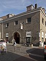
building in Breda, Netherlands  | |||||
| Upload media | |||||
| Instance of | |||||
|---|---|---|---|---|---|
| Location | Breda, North Brabant, Netherlands | ||||
| Street address |
| ||||
| Located on street | |||||
| Heritage designation |
| ||||
 | |||||
|
This is a category about rijksmonument number 10193
|
| Address |
|
Media in category "Halstraat 31, Breda"
The following 3 files are in this category, out of 3 total.
-
 Breda Halstraat31.jpg 2,736 × 3,648; 5.5 MB
-
 Chasse, Breda, Netherlands - panoramio (2).jpg 2,048 × 1,375; 540 KB
-
 Gevels - Breda - 20040118 - RCE.jpg 1,200 × 809; 208 KB
.jpg)
